Charroux, Vienne
| Charroux | ||
|---|---|---|
| Commune | ||
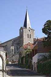 The church of Saint-Sulpice, in Charroux | ||
| ||
 Charroux Location within Nouvelle-Aquitaine region  Charroux | ||
| Coordinates: 46°08′43″N 0°24′16″E / 46.1453°N 0.4044°ECoordinates: 46°08′43″N 0°24′16″E / 46.1453°N 0.4044°E | ||
| Country | France | |
| Region | Nouvelle-Aquitaine | |
| Department | Vienne | |
| Arrondissement | Châtellerault | |
| Canton | Civray | |
| Intercommunality | Pays Charlois | |
| Government | ||
| • Mayor (2001–2014) | Yves Gargouil | |
| Area1 | 44.29 km2 (17.10 sq mi) | |
| Population (2006)2 | 1,215 | |
| • Density | 27/km2 (71/sq mi) | |
| Time zone | UTC+1 (CET) | |
| • Summer (DST) | UTC+2 (CEST) | |
| INSEE/Postal code | 86061 /86250 | |
| Elevation |
115–178 m (377–584 ft) (avg. 165 m or 541 ft) | |
|
1 French Land Register data, which excludes lakes, ponds, glaciers > 1 km2 (0.386 sq mi or 247 acres) and river estuaries. 2 Population without double counting: residents of multiple communes (e.g., students and military personnel) only counted once. | ||
.svg.png)
Charroux is a commune in the Vienne department in the Nouvelle-Aquitaine region in western France.
The remains of the Benedictine Charroux Abbey, founded in the 8th century, are preserved in the town. Said to be the site of the council of Charroux in 989 where the bishops of Aquitaine met to protect the immunity of the clergy and suggested that the church should guarantee that the poor might live in peace.
Demographics
| Year | 1962 | 1968 | 1975 | 1982 | 1990 | 1999 | 2006 |
|---|---|---|---|---|---|---|---|
| Population | 1509 | 1621 | 1644 | 1552 | 1428 | 1320 | 1215 |
See also
References
| Wikimedia Commons has media related to Charroux, Vienne. |
This article is issued from
Wikipedia.
The text is licensed under Creative Commons - Attribution - Sharealike.
Additional terms may apply for the media files.