Genouillé, Vienne
| Genouillé | |
|---|---|
| Commune | |
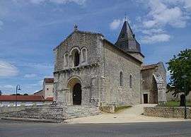 The church in Genouillé | |
 Genouillé Location within Nouvelle-Aquitaine region  Genouillé | |
| Coordinates: 46°06′28″N 0°20′18″E / 46.1078°N 0.3383°ECoordinates: 46°06′28″N 0°20′18″E / 46.1078°N 0.3383°E | |
| Country | France |
| Region | Nouvelle-Aquitaine |
| Department | Vienne |
| Arrondissement | Montmorillon |
| Canton | Civray |
| Intercommunality | Pays Charlois |
| Government | |
| • Mayor (2008–2014) | Robert Bouhier |
| Area1 | 29.80 km2 (11.51 sq mi) |
| Population (2006)2 | 527 |
| • Density | 18/km2 (46/sq mi) |
| Time zone | UTC+1 (CET) |
| • Summer (DST) | UTC+2 (CEST) |
| INSEE/Postal code | 86104 /86250 |
| Elevation |
116–179 m (381–587 ft) (avg. 152 m or 499 ft) |
|
1 French Land Register data, which excludes lakes, ponds, glaciers > 1 km2 (0.386 sq mi or 247 acres) and river estuaries. 2 Population without double counting: residents of multiple communes (e.g., students and military personnel) only counted once. | |
Genouillé is a commune in the Vienne department in the Nouvelle-Aquitaine region in western France. Its population has been declining from its peak of 1495 in 1886 to its current level of 527.
Gallery
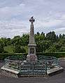 War memorial in Genouillé
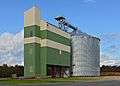 Silo (COREA Poitou-Charentes) in Genouillé
See also
References
| Wikimedia Commons has media related to Genouillé (Vienne). |
This article is issued from
Wikipedia.
The text is licensed under Creative Commons - Attribution - Sharealike.
Additional terms may apply for the media files.