Pressac
| Pressac | |
|---|---|
| Commune | |
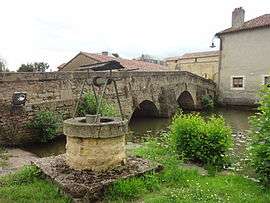 The old bridge, the old well and the Clain river, in Pressac | |
 Pressac Location within Nouvelle-Aquitaine region  Pressac | |
| Coordinates: 46°07′00″N 0°34′18″E / 46.1167°N 0.5717°ECoordinates: 46°07′00″N 0°34′18″E / 46.1167°N 0.5717°E | |
| Country | France |
| Region | Nouvelle-Aquitaine |
| Department | Vienne |
| Arrondissement | Montmorillon |
| Canton | Civray |
| Intercommunality | Montmorillonnais |
| Government | |
| • Mayor (2008–2014) | Roland Debiais |
| Area1 | 49.21 km2 (19.00 sq mi) |
| Population (2006)2 | 548 |
| • Density | 11/km2 (29/sq mi) |
| Time zone | UTC+1 (CET) |
| • Summer (DST) | UTC+2 (CEST) |
| INSEE/Postal code | 86200 /86460 |
| Elevation |
141–216 m (463–709 ft) (avg. 162 m or 531 ft) |
|
1 French Land Register data, which excludes lakes, ponds, glaciers > 1 km2 (0.386 sq mi or 247 acres) and river estuaries. 2 Population without double counting: residents of multiple communes (e.g., students and military personnel) only counted once. | |
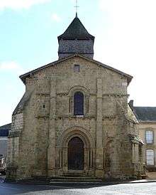
Church in Pressac
Pressac is a commune in the Vienne department in the Nouvelle-Aquitaine region in western France.
Geography
The Clouère forms the commune's north-eastern border.
The Clain flows northward through the middle of the commune and crosses the village.
See also
References
| Wikimedia Commons has media related to Pressac. |
This article is issued from
Wikipedia.
The text is licensed under Creative Commons - Attribution - Sharealike.
Additional terms may apply for the media files.