SEPTA Subway–Surface Trolley Lines
| Subway–Surface Trolley Lines Routes 10, 11, 13, 34, 36 | ||||||||||||||||||||||||||||||||||||||||||||||||||||||||||||||||||||||||||||||||||||||||||||||||||||||||||||||||||||||||||||||||||||||||||||||||||||||||||||||||||||||||||||
|---|---|---|---|---|---|---|---|---|---|---|---|---|---|---|---|---|---|---|---|---|---|---|---|---|---|---|---|---|---|---|---|---|---|---|---|---|---|---|---|---|---|---|---|---|---|---|---|---|---|---|---|---|---|---|---|---|---|---|---|---|---|---|---|---|---|---|---|---|---|---|---|---|---|---|---|---|---|---|---|---|---|---|---|---|---|---|---|---|---|---|---|---|---|---|---|---|---|---|---|---|---|---|---|---|---|---|---|---|---|---|---|---|---|---|---|---|---|---|---|---|---|---|---|---|---|---|---|---|---|---|---|---|---|---|---|---|---|---|---|---|---|---|---|---|---|---|---|---|---|---|---|---|---|---|---|---|---|---|---|---|---|---|---|---|---|---|---|---|---|---|---|---|
 | ||||||||||||||||||||||||||||||||||||||||||||||||||||||||||||||||||||||||||||||||||||||||||||||||||||||||||||||||||||||||||||||||||||||||||||||||||||||||||||||||||||||||||||
 | ||||||||||||||||||||||||||||||||||||||||||||||||||||||||||||||||||||||||||||||||||||||||||||||||||||||||||||||||||||||||||||||||||||||||||||||||||||||||||||||||||||||||||||
| Overview | ||||||||||||||||||||||||||||||||||||||||||||||||||||||||||||||||||||||||||||||||||||||||||||||||||||||||||||||||||||||||||||||||||||||||||||||||||||||||||||||||||||||||||||
| Type | Trolley | |||||||||||||||||||||||||||||||||||||||||||||||||||||||||||||||||||||||||||||||||||||||||||||||||||||||||||||||||||||||||||||||||||||||||||||||||||||||||||||||||||||||||||
| System | SEPTA City Transit Division | |||||||||||||||||||||||||||||||||||||||||||||||||||||||||||||||||||||||||||||||||||||||||||||||||||||||||||||||||||||||||||||||||||||||||||||||||||||||||||||||||||||||||||
| Locale | Philadelphia, Yeadon, and Darby, PA | |||||||||||||||||||||||||||||||||||||||||||||||||||||||||||||||||||||||||||||||||||||||||||||||||||||||||||||||||||||||||||||||||||||||||||||||||||||||||||||||||||||||||||
| Termini |
Overbrook (Route 10) Darby (Routes 11, 13) Angora (Route 34) Eastwick (Route 36) 13th Street (all lines) | |||||||||||||||||||||||||||||||||||||||||||||||||||||||||||||||||||||||||||||||||||||||||||||||||||||||||||||||||||||||||||||||||||||||||||||||||||||||||||||||||||||||||||
| Stations |
8 underground stations, 8 major surface stations | |||||||||||||||||||||||||||||||||||||||||||||||||||||||||||||||||||||||||||||||||||||||||||||||||||||||||||||||||||||||||||||||||||||||||||||||||||||||||||||||||||||||||||
| Services |
Route 10 (Lancaster Avenue) Route 11 (Woodland Avenue) Route 13 (Chester Avenue) Route 34 (Baltimore Avenue) Route 36 (Elmwood Avenue) | |||||||||||||||||||||||||||||||||||||||||||||||||||||||||||||||||||||||||||||||||||||||||||||||||||||||||||||||||||||||||||||||||||||||||||||||||||||||||||||||||||||||||||
| Daily ridership | 132,255 | |||||||||||||||||||||||||||||||||||||||||||||||||||||||||||||||||||||||||||||||||||||||||||||||||||||||||||||||||||||||||||||||||||||||||||||||||||||||||||||||||||||||||||
| Train number(s) | 10, 11, 13, 34, 36 | |||||||||||||||||||||||||||||||||||||||||||||||||||||||||||||||||||||||||||||||||||||||||||||||||||||||||||||||||||||||||||||||||||||||||||||||||||||||||||||||||||||||||||
| Website |
septa | |||||||||||||||||||||||||||||||||||||||||||||||||||||||||||||||||||||||||||||||||||||||||||||||||||||||||||||||||||||||||||||||||||||||||||||||||||||||||||||||||||||||||||
| Operation | ||||||||||||||||||||||||||||||||||||||||||||||||||||||||||||||||||||||||||||||||||||||||||||||||||||||||||||||||||||||||||||||||||||||||||||||||||||||||||||||||||||||||||||
| Opened | 1906 | |||||||||||||||||||||||||||||||||||||||||||||||||||||||||||||||||||||||||||||||||||||||||||||||||||||||||||||||||||||||||||||||||||||||||||||||||||||||||||||||||||||||||||
| Owner | SEPTA | |||||||||||||||||||||||||||||||||||||||||||||||||||||||||||||||||||||||||||||||||||||||||||||||||||||||||||||||||||||||||||||||||||||||||||||||||||||||||||||||||||||||||||
| Operator(s) | SEPTA | |||||||||||||||||||||||||||||||||||||||||||||||||||||||||||||||||||||||||||||||||||||||||||||||||||||||||||||||||||||||||||||||||||||||||||||||||||||||||||||||||||||||||||
| Character | Underground and surface | |||||||||||||||||||||||||||||||||||||||||||||||||||||||||||||||||||||||||||||||||||||||||||||||||||||||||||||||||||||||||||||||||||||||||||||||||||||||||||||||||||||||||||
| Depot(s) | Callowhill, Elmwood | |||||||||||||||||||||||||||||||||||||||||||||||||||||||||||||||||||||||||||||||||||||||||||||||||||||||||||||||||||||||||||||||||||||||||||||||||||||||||||||||||||||||||||
| Rolling stock | Kawasaki K LRV cars | |||||||||||||||||||||||||||||||||||||||||||||||||||||||||||||||||||||||||||||||||||||||||||||||||||||||||||||||||||||||||||||||||||||||||||||||||||||||||||||||||||||||||||
| Technical | ||||||||||||||||||||||||||||||||||||||||||||||||||||||||||||||||||||||||||||||||||||||||||||||||||||||||||||||||||||||||||||||||||||||||||||||||||||||||||||||||||||||||||||
| Line length | 63.7 km (39.6 mi)[1] | |||||||||||||||||||||||||||||||||||||||||||||||||||||||||||||||||||||||||||||||||||||||||||||||||||||||||||||||||||||||||||||||||||||||||||||||||||||||||||||||||||||||||||
| Track gauge | PA gauge: 5 ft 2 1⁄4 in (1,581 mm)[2][3] | |||||||||||||||||||||||||||||||||||||||||||||||||||||||||||||||||||||||||||||||||||||||||||||||||||||||||||||||||||||||||||||||||||||||||||||||||||||||||||||||||||||||||||
| Electrification | Overhead line | |||||||||||||||||||||||||||||||||||||||||||||||||||||||||||||||||||||||||||||||||||||||||||||||||||||||||||||||||||||||||||||||||||||||||||||||||||||||||||||||||||||||||||
| ||||||||||||||||||||||||||||||||||||||||||||||||||||||||||||||||||||||||||||||||||||||||||||||||||||||||||||||||||||||||||||||||||||||||||||||||||||||||||||||||||||||||||||
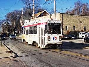
The SEPTA Subway–Surface Trolley Lines are a collection of five SEPTA trolley lines that operate on street-level tracks in West Philadelphia and Delaware County, Pennsylvania and also underneath Market Street in Philadelphia's Center City. The lines, Routes 10, 11, 13, 34, and 36, collectively operate on about 39.6 miles (63.7 km) of route.[1]
SEPTA's Route 15, the Girard Avenue Line, is another streetcar line that is designated green on route maps but is not part of the subway-surface system.
Like Boston's Green Line and San Francisco's Muni Metro, the SEPTA Trolley line is the descendant of a pre-World War II streetcar system. Where Boston and San Francisco's systems use longer, articulated LRT vehicles, Philadelphia uses rigid vehicles roughly four inches longer than the PCC streetcar they somewhat replaced. The lines use Kawasaki K-Car LRVs delivered in 1981-82. The cars are similar to those on Routes 101 and 102, SEPTA's suburban trolley routes, which were delivered around the same time. However, the Subway-Surface cars are single-ended and use trolley poles, while the suburban lines operate in couplets.
Route description
Center City
Starting from their eastern terminus at 13th Street Station near City Hall, the trolleys loop around in a tunnel under City Hall before stopping at under Dilworth Park at 15th Street station and then realign back under Market Street.
All five routes also stop at 19th Street, 22nd Street, 30th Street, and 33rd Street, which are all underground stations. From 15th to 30th Streets, they run in the same tunnel as SEPTA's Market–Frankford Line, which runs express on the inner tracks while the trolleys utilize the outer ones.
Passengers may transfer free of charge to the Market–Frankford Line at 13th, 15th, and 30th Streets, as well as to the Broad Street Line at 15th Street. Connections to the Regional Rail are also available via underground passageways connecting 13th and 15th Street stations to Suburban Station, one of the city's main commuter rail terminals.
University City
After traveling under the Schuylkill River, the trolley lines provide access to 30th Street Station, a passenger terminal located across the street from the trolley and rapid transit station. Connection is available to Regional Rail, many Amtrak services, and New Jersey Transit's Atlantic City Line. An underground passageway that connects these two stations is currently closed. The closure was due to passenger safety issues after a passenger attack in the 1990s. In 2016, the 30th Street Station District proposed overhauling both 30th Street Station's SEPTA and trolley stations including, by public demand, the reopening the tunnel that connects the two (currently separate) stations, thus ceasing the need for passengers to resurface, walk outside to cross the busy 30th Street, and then enter the other station. The timeline called for the tunnel overhaul to be part of Phase 1 and thus completed by 2020. [4]
All routes then stop at 33rd Street, near Drexel University. After this stop, Route 10 diverts from the others and emerges from the tunnel at the 36th Street Portal just south of Market Street, then turns north onto 36th Street and then northwest along Lancaster Avenue and other surface streets. The other four lines make underground stops at 36th and Sansom streets and 37th and Spruce streets on the campus of the University of Pennsylvania before surfacing at the 40th Street Portal near Baltimore Avenue, heading southwest on surface streets.
Points south and west
The Route 11 line, traveling along Main Street in Darby, crosses CSX Transportation at grade. This, along with the TECO streetcar is currently one of the few locations in the U.S. with an at-grade crossing between a trolley line and a major freight rail line.[5][6]
Diversion services
When tunnels are closed due to maintenance, an accident or some other obstruction, all five trolleys can be diverted onto auxiliary surface tracks west of the 40th Street Portal.
Tracks for Route 10 start at Lancaster Avenue (Route 10) and proceed southbound along 40th Street. At Market Street, the line connects to the Market–Frankford Line at its 40th Street station. The surface tracks continue southbound to Spruce Street, where they splits either eastbound or westbound. Westbound tracks run to 42nd Street where they turn south to either Baltimore Avenue (Route 34), Chester Avenue (Route 13), or Woodland Avenue (Routes 11 and 36).
Tracks for the other four routes run northbound along 42nd Street, then turning east onto Spruce Street and then north onto 38th Street (US 13). From here, it travels to Filbert Street, then turning left and crossing the 40th Street tracks. When Filbert Street terminates at 41st Street, the tracks turn right, and head north until reaching Lancaster Avenue.[7]
Another set of diversionary trolley tracks begin near the 49th Street Regional Rail station, connecting Chester Avenue to Woodland Avenue (where Routes 11 and 36 separate) by way of 49th Street.
History
The Subway–Surface lines are remnants of the far more extensive streetcar system that developed in Philadelphia after the arrival of electric trolleys in 1892. Several dozen traction companies were consolidated in 1902 into the Philadelphia Rapid Transit Company. The PRT funneled the West Philadelphia lines into subway tunnels as they approached the city center. After the PRT declared bankruptcy in 1939, it was reopened as the Philadelphia Transportation Company (PTC), which was absorbed into SEPTA in 1968.[8]
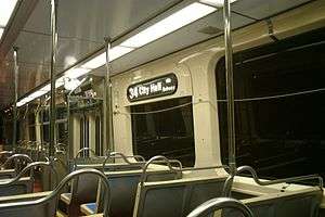
In October 2006, University of Pennsylvania's class of 1956 funded the construction of an innovative portal for one of the eastbound entrances of the 37th Street station: a replica of a Peter Witt trolley of the kind manufactured by J. G. Brill and Company from 1923–26. Operated by the Philadelphia Transportation Company, these trolleys brought university students to the campus and to Center City until 1956. Routes 11, 34 and 37 ran through the Penn campus on Woodland Avenue and Locust Streets for nearly 65 years. In 1956, the trolley route was buried to enable the university to unify its campus, with Woodland Avenue and Locust Street becoming pedestrian walkways.
Routes
All routes terminate at 15th Street station between 12:30am and 5:00am when 13th Street is closed. On Sunday evenings and during unexpected diversions, all routes are diverted to surface streets and terminate at 40th Street station. Former trolley routes, which have since been replaced with bus service, are shaded in gray.
| Length in miles (km)[9] |
Date closed | Western terminus | Eastern terminus | Main streets of travel | Assigned depot | Notes | |
|---|---|---|---|---|---|---|---|
| Route 10 | 5.9 (9.5) | Overbrook: 63rd–Malvern | Center City 15th–Market (12:30-5:00am) 40th–Market (Sundays after 10pm) 13th–Market (all other times) |
63rd Street, Lansdowne Avenue, Lancaster Avenue | Callowhill | ||
| Route 11 | 6.7 (10.8) | Darby: Transportation Center | Woodland Avenue | Elmwood | |||
| Route 13 | 6.9 (11.1) | Chester Avenue | Elmwood | Some trips terminate at Yeadon Loop in Yeadon | |||
| Route 31 | 1956 | Overbrook Park: Lansdowne & Haverford Avenues Loop | 63rd Street, Market Street | Callowhill | Replaced by bus service | ||
| Route 34 | 4.8 (7.7) | Angora: 61st–Baltimore | Baltimore Avenue | Elmwood | |||
| Route 36 | 7.0 (11.3) | Eastwick: 80th–Eastwick | Island Avenue, Elmwood Avenue | Elmwood | Some trips terminate at 73rd–Elmwood station in Eastwick | ||
| Route 37 | 1955 | Chester: 3rd & Crosby Streets | Industrial Highway, Eastwick Avenue, Woodland Avenue | Woodland | Replaced by bus service | ||
| Route 38 | 1955 | Parkside: 48th Street & Parkside Avenue Loop | Parkside Avenue, 40th Street, Baring Street | Callowhill | Replaced by bus service |
See also
References
- 1 2 Smith, Jr., Bill W. (November 2011). "U.S. Urban Rail Transit Lines Opened From 1980" (pdf). SEPTA.org. pp. 1–100. Retrieved 2013-11-02.
- ↑ "The history of trolley cars and routes in Philadelphia". SEPTA. June 1, 1974. p. 2. Retrieved 2014-06-11.
An early city ordinance prescribed that all tracks were to have a gauge of 5' 2 1⁄4.
- ↑ Hilton, George W.; Due, John Fitzgerald (January 1, 2000). The Electric Interurban Railways in America. Stanford University Press. Retrieved 2014-06-10.
Worst of all, not all city systems were built to the standard American and European gauge of 4'-8 1⁄2". Pittsburgh and most other Pennsylvania cities used 5'-2 1⁄2", which became known as the Pennsylvania trolley gauge. Cincinnati used 5'-2 1⁄2", Philadelphia 5'-2 1⁄4", Columbus 5'-2", Altoona 5'-3", Louisville and Camden 5'-0", Canton and Pueblo 4'-0", Denver, Tacoma, and Los Angeles 3'-6", Toronto an odd 4'-10 7⁄8", and Baltimore a vast 5'-4 1⁄2.
- ↑ "30th Street Station District draft plan: Reopen SEPTA tunnel by 2020, cap rail yards by 2050". PlanPhilly | 30th Street Station District draft plan: Reopen SEPTA tunnel by 2020, cap rail yards by 2050. Retrieved 2018-07-20.
- ↑ Philadelphia Transit; Streetcars;Route 11 (Kavanaugh Transit Systems)
- ↑ davidwilson1949 (July 6, 2003). 20030706 26 Main St. Crossing CSXT in Darby (6071320235) (photograph). Retrieved December 31, 2015.
- ↑ SEPTA Subway-Surface Lines map
- ↑ "Studio 34's Eponymous Trolley, or, A Short History of Route 34". Retrieved 2008-03-11.
- ↑ "SEPTA - Spring 2012 Route Statistics" (PDF). Southeastern Pennsylvania Transportation Authority. 2012. Retrieved 2013-06-28.
.jpg)
External links
Route map:
| Wikimedia Commons has media related to SEPTA Subway-Surface Trolley Lines. |
- SEPTA subway and trolley schedules
- Map of subway surface lines in West Philadelphia
- Tramway, Light Railway and LRT in Philadelphia (PublicTransit.US)
- Transit Systems in Philadelphia and Southeast Pennsylvania Electric Railway map (Chicago Railfan.net)
- WorldNYCSubway.org - SEPTA Subway-Surface Streetcar Lines