Roosevelt Boulevard (Philadelphia)
| |
|---|---|
 Map of the city of Philadelphia with Roosevelt Boulevard highlighted in red | |
| Route information | |
| Maintained by PennDOT and City of Philadelphia | |
| Length | 14.9 mi[1] (24.0 km) |
| Major junctions | |
| South end |
|
|
| |
| North end |
|
| Location | |
| Counties | Philadelphia |
| Highway system | |


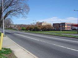
Roosevelt Boulevard, officially named the Theodore Roosevelt Memorial Boulevard and often referred to, chiefly by Philadelphian locals, simply as "the Boulevard,"[2] is a major traffic artery through North and Northeast Philadelphia. The road begins at the Schuylkill Expressway in Fairmount Park, running as a freeway also known as the Roosevelt Boulevard Extension or the Roosevelt Expressway through North Philadelphia, then transitioning into a twelve-lane divided highway that forms the spine of Northeast Philadelphia to its end at the city line.
Historically, Roosevelt Boulevard is a part of the Lincoln Highway, the first road across America, which ran for 3,389 miles (5,454 km) from Times Square in New York City to Lincoln Park on the Pacific Ocean in San Francisco, California.
Today, Roosevelt Boulevard is designated as US 1 (north of the Roosevelt Expressway), US 13 (between Hunting Park Avenue and Robbins Street), and Pennsylvania Route 63 (between Red Lion and Woodhaven Roads).[3]
The road is notorious for two intersections which have been designated the second and third most dangerous intersections in the country by State Farm Insurance, at Red Lion Road and Grant Avenue respectively.[4] The dangerous reputation of the road led to installation of the first red light cameras in Philadelphia in 2004. The road has been the scene of numerous pedestrian casualties and studies are underway to allow pedestrian traffic to be separated from vehicular traffic.[5]
Route description
Roosevelt Expressway
The Roosevelt Boulevard Extension, also known as the Roosevelt Expressway, begins at the Schuylkill Expressway in Fairmount Park adjacent to the Philadelphia city line, as an expressway also known as the Roosevelt Boulevard Expressway U.S. Route 1. It crosses the Schuylkill River via the Twin Bridges and runs eastward through the neighborhoods of East Falls and Hunting Park. The Roosevelt Expressway interchanges with Broad Street (Pennsylvania Route 611) and ends at an interchange with US 13 (Roosevelt Boulevard), at which point US 1 merges onto the Roosevelt Boulevard and continues northeast along with US 13.[6]
Roosevelt Boulevard
The Roosevelt Boulevard begins at an intersection with Hunting Park Avenue, continuing northeast as a part of US 13. The road crosses Broad Street (PA 611) before US 1 (Roosevelt Expressway) merges in at an interchange and Roosevelt Boulevard becomes a 12-lane surface arterial with local and express lanes and at-grade intersections, carrying US 1 and US 13.[6]
The road continues east through Hunting Park and Feltonville, where it curves and starts running in a northeasterly direction. It meets Oxford Avenue (Pennsylvania Route 232) at a large traffic circle known as Oxford Circle (the express lanes pass through the circle via an underpass). The road carries northbound U.S. Route 13 one more mile until it splits off onto Robbins Street and Levick Street (both one-way streets). The road continues to a large interchange with Cottman Avenue (Pennsylvania Route 73) and the Roosevelt Mall. The traffic circle with Holme and Solly Avenues known as the Pennypack Circle was rebuilt and no longer exists. There is access to both Solly and Holme Avenues from the local lanes both north and south bound. It continues past Pennypack Park and Northeast Philadelphia Airport, passing through two notoriously dangerous intersections[4] with Grant Avenue and Red Lion Road.[6]
The road continues northeast, interchanging with Woodhaven Road (Pennsylvania Route 63), then narrowing as it approaches its end at an intersection on the Philadelphia-Bucks County border. After 2 traffic light intersections in Trevose in Bensalem Township, U.S. 1 continues as a freeway to the north.[6]
History
Proposed in 1903 by Mayor Samuel H. Ashbridge as part of the City Beautiful movement, the 300-foot-wide thoroughfare originally extended from Broad Street to the Torresdale neighborhood, and was first named Torresdale Boulevard, then Northeast Boulevard in 1914 when the road was completed. On its extension to Pennypack Creek in 1918, it was finally renamed to Roosevelt Boulevard, in honor of Theodore Roosevelt. The road was designated U.S. 1 in 1926, and was extended through Philadelphia to neighboring Bucks County in the post-World War II years.
The Roosevelt Expressway was built to connect the boulevard with the nearby Schuylkill Expressway (I-76).
In 1998 a series of gang-related criminal rock throwing attacks on cars driving near Ridge Avenue, Henry Avenue and Fox Street "terrorized" Philadelphia drivers.[7][8]
In 2000, by act of the state legislature, the Boulevard was designated the "Police Officer Daniel Faulkner Memorial Highway" in memory of Daniel Faulkner, a Philadelphia police officer whom Mumia Abu-Jamal was convicted of having slain in the line of duty in 1981. The designation is alongside the roadway's official name of Roosevelt Boulevard.[9][10]
There have been several plans to change the boulevard into an expressway-like artery, like the Roosevelt Expressway itself, and construct a subway underneath the boulevard, but no such plans have been acted upon.
Today, Roosevelt Boulevard is among the most congested arteries in the country. According to a 2001 report by State Farm Insurance, the second- and third-worst intersections in the country are both found on the Boulevard, at Red Lion Road and Grant Avenue, respectively, only a mile apart from each other. Red-light enforcement cameras have been installed at these intersections, as well as Cottman Avenue, and have been operational since June 1, 2005. New cameras installed at the intersections with 9th Street, Mascher Street, Levick Street, Rhawn Street, Welsh Road, and Southampton Road became operational in summer 2007. [11] Additional plans include adding cameras at Devereaux Avenue and Tyson Avenue.
Proposed subway
The Roosevelt Boulevard Subway is a proposed SEPTA subway line that would run along Roosevelt Boulevard. The cost of the project is estimated to be around $4.6 billion, based on a similar 2 mile long tunnel project in Seattle. The project would consist of boring a 6 mile long tunnel to be connected to an elevated section for the remainder of the line.[12] Alternatively, an enhanced bus route similar to Pittsburgh's Martin Luther King Jr. East Busway (a BRT system) could also be implemented in its place. The route was first proposed in 1913 as part of the Broad Street Subway line from Adams Avenue.[13]
Major intersections
The entire route is in Philadelphia, Philadelphia County.
| Location | mi[1] | km | Destinations | Notes | |
|---|---|---|---|---|---|
| West Fairmount Park | 0.0 | 0.0 | Exit 340B on I-76 | ||
| Schuylkill River | Twin Bridges | ||||
| East Falls–Allegheny West | 0.4 | 0.64 | Ridge Avenue / Kelly Drive | Southbound exit and northbound entrance; site of proposed interchange with Manayunk Expressway | |
| 1.0 | 1.6 | Fox Street / Henry Avenue | Southbound exit and entrance | ||
| Wissahickon Avenue south – Hunting Park Avenue | Northbound exit and southbound entrance | ||||
| Germantown–Nicetown | 1.5 | 2.4 | Wissahickon Avenue north – Germantown Avenue | Northbound exit and southbound entrance | |
| Hunting Park–Fern Rock | 2.3 | 3.7 | Southbound exit is via US 13 | ||
| 2.8 | 4.5 | Southern terminus of concurrency with US 13; southbound exit and northbound entrance | |||
| 3.1 | 5.0 | Wingohocking Street / 9th Street | At-grade intersection except northbound exit; western terminus of frontage roads | ||
| Oxford Circle | 6.4 | 10.3 | Interchange with Oxford Circle; no southbound signage for Bridge Street | ||
| Oxford Circle–Mayfair | 7.1 | 11.4 | One-way northbound; northern terminus of northbound concurrency with US 13 | ||
| 7.2 | 11.6 | One-way southbound; northern terminus of southbound concurrency with US 13 | |||
| 8.3 | 13.4 | Interchange; no southbound signage for Ryan Avenue | |||
| Rhawnhurst | 9.4 | 15.1 | Holme Avenue south / Solly Avenue north | Interchange | |
| Bustleton | 10.6 | 17.1 | Right turns via frontage roads; southern terminus of PA 532 | ||
| Somerton | 12.4 | 20.0 | Right turns via frontage roads; southern terminus of concurrency with PA 63 | ||
| 13.7 | 22.0 | Interchange with frontage roads; northern terminus of concurrency with PA 63 | |||
| 14.9 | 24.0 | Continuation into Bucks County | |||
1.000 mi = 1.609 km; 1.000 km = 0.621 mi
| |||||
See also

References
- 1 2 Google (July 13, 2018). "Roosevelt Boulevard and Expressway" (Map). Google Maps. Google. Retrieved July 13, 2018.
- ↑ "Focus on lethal Roosevelt Blvd". The Philadelphia Inquirer. December 13, 2006.
- ↑ "Roosevelt Expressway (US 1): Historic Overview". The Roads of Metro Philadelphia.
- 1 2 "List of 'most dangerous' intersections released". CNN. June 27, 2001. Archived from the original on 2007-04-05.
- ↑ "Study Evaluates the Effectiveness of Red Light Camera Enforcement in Philadelphia". Government Technology. January 31, 2007.
- 1 2 3 4 Pennsylvania Official Tourism and Transportation Map (PDF) (Map). Pennsylvania Department of Transportation. 2006. Retrieved March 26, 2007.
- ↑ Goldblatt, Michael (19 November 1998). "A Deadly Game". The Jewish Exponent. Retrieved 6 May 2015.
- ↑ Frisby, Mann (23 October 1998). "Cops Hold 3 for Throwing Rocks at Cars". Philadelphia Daily News. Retrieved 6 May 2015.
- ↑ "HB 2503. PN 3498" (PDF). Commonwealth of Pennsylvania Legislative Journal (40): 1431. June 14, 2000.
- ↑ Walker, Julian. "It's Danny's way". The Northeast Times. Archived from the original on March 25, 2009.
- ↑ "Archived copy". Archived from the original on 2015-01-07. Retrieved 2015-02-14.
- ↑ Smith, Sandy (May 10, 2015). "The Roosevelt Boulevard Subway Is Dead … Unless It Isn't". Philadelphia Magazine.
- ↑ Saksa, Jim (May 19, 2015). "Mass transit plans take shape for Roosevelt Blvd". Philadelphia Inquirer.
External links
- Phillyroads.com Article covering history of the Boulevard
- Greater Philadelphia GeoHistory Network - historical maps and atlases of Philadelphia
- Article on US-1 with history of Roosevelt Boulevard
- Map of Dangerous Intersections in Philadelphia
Coordinates: 40°01′59″N 75°04′48″W / 40.032937°N 75.079879°W