22nd Street station (SEPTA)
22nd Street | |||||||||||
|---|---|---|---|---|---|---|---|---|---|---|---|
 Station platform | |||||||||||
| Location |
22nd & Market Streets Philadelphia, Pennsylvania | ||||||||||
| Coordinates | 39°57′15″N 75°10′35″W / 39.954124°N 75.176410°WCoordinates: 39°57′15″N 75°10′35″W / 39.954124°N 75.176410°W | ||||||||||
| Owned by | SEPTA | ||||||||||
| Line(s) | |||||||||||
| Platforms | 2 side platforms | ||||||||||
| Tracks | 4 (2 rapid transit, 2 tram) | ||||||||||
| Connections | Former B&O Station | ||||||||||
| Construction | |||||||||||
| Structure type | Underground | ||||||||||
| History | |||||||||||
| Opened | October 15, 1955 | ||||||||||
| Electrified | Overhead lines | ||||||||||
| Services | |||||||||||
| |||||||||||
| Location | |||||||||||
 22nd Street Location within Philadelphia | |||||||||||
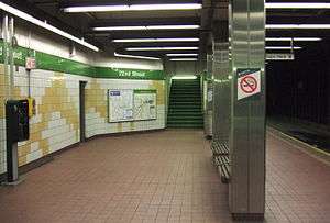
22nd Street station is a subway station in Center City Philadelphia that serves the SEPTA Subway–Surface Trolley Lines. Similar to 19th Street station, three blocks east of it, the station has two side platforms and a total of four tracks. The station serves only subway-surface trolleys on the two outer tracks; the Market-Frankford Line subway uses the two inner tracks and bypasses the station as it travels between 15th Street and 30th Street station. Since the station serves only trolleys, there is no fare collection at the station; all fares are paid on board the trolley itself. This will change with the SEPTA Key system, as turnstiles will be installed at this station.
The station was constructed by the Philadelphia Transit Company in 1955, a replacement for the 24th Street station.
History
24th Street station (demolished 1956) was a subway-surface trolley station in use from 1905 to 1955. It was built by the Philadelphia Rapid Transit Company (PRT), and for the first two years formed part of a subway-surface trolley loop operating underground between 15th Street and the Schuylkill River.[1] In 1907, the Market Street Subway-Elevated Line was completed from 15th Street to 69th Street.[1] The "Market Street El" featured a bridge – located north of Market Street and south of Filbert Street – that carried both the subway and subway-surface lines over the Schuylkill River. The PRT bridge connected trolley lines in West Philadelphia to the underground subway-surface loop in Center City. 24th Street station was constructed of wood, and was the only subway-surface station not physically underground. It was built atop an embankment, along the trolley tracks as they rose to cross the PRT bridge. The station served Routes 10, 11, 31 (until 1949), 34, 37 and 38.
The Baltimore & Ohio Railroad tracks ran north-south along the east bank of the Schuylkill River, and the B&O Philadelphia passenger station was located at 24th & Chestnut Streets, one block south of Market Street (no connections to 24th Street station).
The Philadelphia Rapid Transit Company went bankrupt in 1939, and was reorganized as the Philadelphia Transportation Company (PTC).[2] The PTC subway tunnel under the Schuylkill River was completed in 1955. On October 15, the eastbound side of 24th Street station was closed to passenger service and the trolley lines were re-routed through the new subway tunnel. On the same day, the current 22nd Street station opened.[3] The following month, on November 6, the westbound side of 24th Street station closed, and all passenger service to it was discontinued. The PRT bridge, that formerly had carried subway trains and subway-surface trolleys and over the Schuylkill River, was torn down by June 20, 1956.
The Philadelphia Transportation Company was absorbed into the Southeast Pennsylvania Transportation Authority (SEPTA) in 1968. Nothing remains of the 24th Street station—its site is open space along the east bank of the Schuylkill River, between the Market Street Bridge and what is now known as the J.F.K. Boulevard Bridge.
Station layout
| G | Street Level | Entrances/Exits |
| M | Mezzanine | to entrances/exits, fare control |
| P Platform level |
Side platform, doors will open on the right | |
| Westbound | ← Trolley Lines toward West Philadelphia (30th Street) | |
| Westbound | ← Market–Frankford Line does not stop here | |
| Eastbound | → Market–Frankford Line does not stop here → | |
| Eastbound | → Trolley Lines toward 13th–Market (19th Street) → | |
| Side platform, doors will open on the right | ||
Gallery
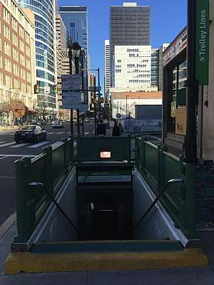 22nd Street trolley station with the site of the 2013 Philadelphia building collapse, site of the future “June 5 Memorial”, visible behind station on the right.
 22nd Street station side view
References
- 1 2 John Hepp, "Subways and Elevated Lines," The Encyclopedia of Greater Philadelphia (Rutgers University, 2013).
- ↑ "Studio 34's Eponymous Trolley, or, A Short History of Route 34". Retrieved 2008-12-20.
- ↑ UrbanRail.net (Philadelphia)