Blue, Green, and Waterfront Lines (Cleveland)
| Blue Line Green Line Waterfront Line | |
|---|---|
|
| |
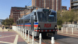 Waterfront (Green) line train in Downtown Cleveland | |
| Overview | |
| Type | Light rail/Tram |
| System | RTA Rapid Transit |
| Locale | Cleveland and Shaker Heights, Cuyahoga County, Ohio |
| Termini |
South Harbor (Waterfront Line) Tower City (All) Warrensville–Van Aken (Blue Line) Green Road (Green Line) |
| Stations |
35 total: (18 Blue, 18 Green, 7 Waterfront)
|
| Services |
3 lines:[1]
|
| Ridership | 2,855,800 (annually, 2012)[2] |
| Operation | |
| Opened |
December 17, 1913 (Green Line) April 11, 1920 (Blue Line) July 10, 1996 (Waterfront Line)[3] |
| Owner |
Cleveland & Youngstown Railroad (1913–1920) Cleveland Interurban Railroad (1920–1929) Metropolitian Utilities (1929–1935) Union Properties (47%), Guardian Savings and Trust (33%) and Cleveland Trust (20%) (1935–1944) City of Shaker Heights (1944–1975) GCRTA (1975–present) |
| Operator(s) |
Cleveland Railway (1913–1930) Cleveland Interurban Railroad (1930–1944) City of Shaker Heights (1944–1975) GCRTA (1975–present) |
| Rolling stock | 34 |
| Technical | |
| Line length | 15.3 miles (24.6 km)[4] |
| Number of tracks | 2 |
| Track gauge | 4 ft 8 1⁄2 in (1,435 mm) standard gauge |
| Electrification |
Overhead catenary, 600 Volts DC[5] |
The Blue Line, Green Line, and Waterfront Line are the light rail components of the RTA Rapid Transit, a rail transit system in greater Cleveland and Shaker Heights, Cuyahoga County, Ohio. The Greater Cleveland Regional Transit Authority designates the lines as Route 67. The lines are also referred to by their former names; the respective boulevards that they travel on: the Van Aken Line (Blue) and the Shaker Line (Green). The system dates to 1913,[3] making it one of the few surviving American "light rail" systems of the original streetcar era during the late 19th and early 20th centuries.
Route description
Waterfront Line
The first 2.2 miles (3.5 km) of both lines is designated the Waterfront Line as it travels near the shoreline of Lake Erie and the east bank of the Cuyahoga River. The northernmost terminus is South Harbor located adjacent to the Municipal Parking lot. The lines extend generally west-southwest directly adjacent to the former Lake Shore and Michigan Southern Railway and New York Central Railroad tracks now used by Norfolk Southern and Amtrak, with stations at East 9th Street (North Coast station adjacent to the Rock and Roll Hall of Fame) and West 3rd Street (adjacent to FirstEnergy Stadium). Between these stations, trains will stop at Cleveland's Amtrak station upon request.
The line then contains a large loop allowing it to turn from west-southwest to south-southeast, cross over the CSX tracks and travel along the east bank of The Flats. There are two stations in The Flats, Flats East Bank and Settlers Landing. In The Flats are three grade crossings, the only ones west of Shaker Square.
The line then turns east and climbs up from The Flats in two cuts on either side of the Red Line. It merges onto the Red Line tracks and travels through Tower City station. The Blue and Green Lines use the eastern end of the Tower City station where two low-level island platforms are provided. Tower City marks the end of the portion designated as the Waterfront Line.
From April 2010 through May 2013, RTA completely eliminated weekday regularly scheduled Waterfront Line service due to low ridership and trains ran on the line only on weekends and for special events. Though seven-day-a-week service on the line was restored, a number of trains continue to use Tower City as a western terminus.
Tower City is the major station on all RTA Rapid Transit lines. It is the main station serving downtown Cleveland and it provides a convenient transfer point between the Red Line and the Blue and Green Lines.
Interurban portion
From Tower City to just east of East 55th Street, the Blue and Green Lines share track with the Red Line for 2.6 miles (4.2 km) along a private right-of-way originally acquired in 1930 to bring intercity trains into Cleveland Union Terminal (the site of today's Tower City Center). The East 34th–Campus station and the East 55th station are shared by the heavy rail rapid transit Red Line and the light rail Blue and Green Lines on the same platform, an arrangement unique in North American rail transit. The shared stations have low platforms for the Blue and Green Lines directly adjacent to high platforms for the Red Line. RTA Central Rail yards and headquarters are located at the East 55th station, where trains of all rail lines are stored and serviced.
East of East 55th, the Blue and Green Lines split from the Red Line and travel east on a separate, dedicated, grade separated right-of way. A complex of tunnels existed at this junction to provide means for the Blue and Green Line trains to switch from right to left side running from East 55th to Tower City, but right side running is now used throughout the system, and the tunnels have been closed.
The private right of way extends from this junction to Woodhill Road at the western end of Shaker Boulevard and then below grade through an excavated cut in the median of Shaker Boulevard to Shaker Square. Along this portion of the lines are East 79th station, Woodhill station and East 116th Station. The lines then rise to street level at Shaker Square.
Suburban portion
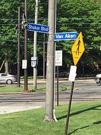
From Shaker Square eastward, both lines enter Shaker Heights and operate at street level with grade crossings, reflecting this portion of the lines' history as streetcar lines. The Blue and Green Lines separate from each other just east of Shaker Square at 41°29′02″N 81°35′20″W / 41.483798°N 81.588824°W, with the Blue Line extending southeast in the median of Van Aken Boulevard and the Green Line continuing east in the median of Shaker Boulevard. The station-stops east of Shaker Square on both lines are adjacent to street intersections and most comprise merely concrete platforms with simple shelters. Both lines have grade crossings in this area, except for the Blue Line at Lee Road where the line descends into an excavated cut and under a bridge carrying Lee Road over the tracks and the Green Line from Warrensville Road eastward. The central median of Shaker Boulevard expands at Warrensville Road—it was originally planned for a high-speed parkway—and the Green Line continues along this median with Warrensville Road crossing on a bridge overhead. There is also a bridge at Green Road, although the station is actually just west of the bridge and only layover tracks extend beneath the bridge.
The Blue Line terminates at Warrensville Road and Van Aken Boulevard, and the Green Line terminates at Green Road and Shaker Boulevard.
Future extensions
Plans have been drawn up to loop the Waterfront Line back through downtown to Tower City along city streets, but it seems unlikely to move forward in the near future. With the completion of the HealthLine project, a new heavy rail line has been proposed that will connect Rocky River and Euclid. There has also been a proposal to extend the Waterfront line, from the current South Harbor (municipal parking lot at East 14th Street) eastward along the lakefront, to the Glenville or Collinwood neighborhoods or to Euclid or beyond. This eastward expansion is still a part of the Cleveland Planning Commission's Lakefront Development proposal.
An additional station on the Waterfront Line section that loops over the NS tracks, is a part of nearly every plan for that area. Initially the Cleveland World Trade Center would have had the station in the lobby of the facility, then the Eaton Corp headquarters, but neither project was built. Currently the announced Lakefront Redevelopment plan has the proposed station as an integral part.[6]
Designations
Originally, The Blue and Green lines held the designations of 67 and 67A. These were later changed to and from 67X and 67AX. This remained with the opening of the Waterfront "line" extension of the Blue and Green lines. In the mid 2010s, the Waterfront line became a separate designation from the 67 and 67A Blue and Green lines. The Waterfront line was briefly designated as 67W, before the three routes united under the 67 designation, which is now internal and not shown on official timetables.
History
The Blue and Green Lines are the direct, continuously operating descendants of the privately owned Cleveland & Youngstown Railroad, Cleveland Interurban Railroad and later the municipally owned Shaker Heights Rapid Transit, built as streetcar lines to connect the streetcar suburb of Shaker Heights, Ohio to downtown Cleveland. These lines were the only ones to survive the bustitution of Cleveland's transit system, partly due to their use of grade-separated trackage to across much of the east side of Cleveland.
Cleveland & Youngstown Railroad


The Van Sweringen brothers purchased the land of what is now Shaker Heights in 1906 intending to create a planned suburban community. They knew that the success of their plans depended upon the availability of streetcar service to downtown Cleveland, so they persuaded the Cleveland Railway to extend its Euclid Heights trolley line along Fairmount Boulevard from Cedar Road to Lee Road, which was completed by 1907.
To improve travel times to downtown, the Vans organized the Cleveland and Youngstown Railroad. On October 27, 1911, with a population of only 200, the Village of Shaker Heights was incorporated, and two years later on December 17, 1913 the first section of the C&Y opened, 1.6 miles (2.6 km) from Coventry Road east down the median of the future Shaker Boulevard (then part of Coventry Road) to Fontenay Road (west of Eaton Road). The line connected to downtown Cleveland via a line along Coventry Road, north to the 1907 Shaker Heights streetcar line on Fairmount Boulevard in Cleveland Heights. On May 20, 1915 the eastern terminus of the C&Y was extended from Fontenay Road to Courtland Boulevard.
As construction progressed in Shaker Heights, the Van Sweringens realized that the connection to Cleveland Railway's streetcar system through Cleveland Heights resulted in a slow trip to downtown. They planned for a grade-separated right-of-way all the way to downtown that could significantly reduce travel times for commuters, and thus increase the desirability of their suburb. In 1915 they acquired a majority interest in the New York, Chicago and St. Louis Railroad (the Nickel Plate Road), mainly to allow for a line next to a relocated NYC&StL.
Cleveland Interurban Railroad
The Van Sweringens rapid line officially opened in April 1920, running west from Coventry Road down the median of the new Shaker Boulevard to Woodhill Road, then across the Cleveland Short Line Railway (New York Central Railroad) and alongside a CSL branch to East 55th Street. West of East 55th Street, where the CSL branch crossed over the parallel Nickel Plate, the new streetcar line also crossed the Nickel Plate, continuing west between the branch and Nickel Plate, then up a ramp to the intersection of the Kingsbury Viaduct (East 34th Street) and Broadway. From there, the CIRR cars traveled along the tracks of Cleveland Railway's Broadway line, using street-running for the remainder of the trip downtown.
Also in April 1920 a branch line was opened to the south and east of what was Moreland Circle (today, Shaker Square). This line split from the other line at Shaker Square and ran southeast down the median of Moreland (later renamed Van Aken) Boulevard to Lynnfield Road. In 1928, the Shaker Boulevard line was extended east from Courtland Boulevard to Warrensville Center Road.
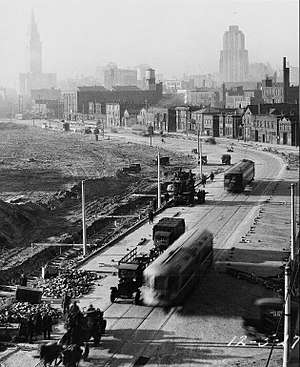
As the Van Sweringens' railroad plans grew, they constructed a new Union Terminal for Cleveland. Cleveland Union Terminal (CUT) opened in 1930, along with a new grade-separated right-of-way with side-by-side lines for steam railroads and interurban streetcars, including the CIRR. Although their plans for another interurban line never materialized (the right-of-way was later used for the Red Line), the CIRR immediately began operations via the new right-of-way into the north part of CUT specially reserved for interurban train service. The CIRR no longer needed to run on city streetcar tracks and the ramp to Broadway and East 34th Street was removed. The first CIRR trains rolled into CUT on July 20. On the same day, the Moreland or Van Aken line was extended to its present terminus at Warrensville Road. A further extension of the Shaker Boulevard line moved the eastern terminus to Green Road in 1936.[7]
Shaker Heights Rapid Transit
On September 6, 1944, the City of Shaker Heights took over the financially struggling lines and began operating them as Shaker Heights Rapid Transit. The city lacked funds for major line extensions. However, it did modernize the fleet with the purchase of PCC cars beginning in 1947.
In 1955 the Cleveland Transit System (which was formed in 1942 when the City of Cleveland took over the Cleveland Railway Company) opened the first section of the city's new rapid transit line, now known as the Red Line. It used much of the right-of-way and some of the catenary poles from the Van Sweringen's planned east-west interurban line adjacent to the NYC&StL tracks. The first section of the CTS rapid transit east from Cleveland Union Terminal included 2.6 miles (4.2 km) and two stations shared with the Shaker Heights Rapid Transit line, necessitating split platforms with low-level sections (for Shaker Heights rapid transit cars) and high-level sections (for CTS rapid transit cars).
Greater Cleveland Regional Transit Authority
By the 1970s the City of Shaker Heights was struggling to maintain the Shaker Heights Rapid Transit and in Cleveland, CTS was facing financial problems with its rapid transit and bus system. Significant federal money was available, but only if a regional transit system was formed. In 1974, the Greater Cleveland Regional Transit Authority (or RTA) was organized to take over the municipal transit system in Cleveland and others throughout Cuyahoga County. Voters approved a county-wide sales tax increase to help subsidize the transit system and RTA officially took over the Shaker Heights Rapid Transit lines on July 14, 1975. In September 1979, RTA adopted a new designation for the rapid transit lines. The old CTS Rapid Transit became the Red Line and the Shaker Rapid Transit lines became the Green and Blue Lines.
In 1980, RTA undertook a complete renovation of the Green and Blue Lines, with new track, ballast, poles and overhead wiring. Existing stations were demolished and new stations constructed. The project necessitated closing the Green Line east of Shaker Square for most of the summer of 1980 and the Blue Line east of Shaker Square for most of the summer of 1981, with substitute bus shuttles and single-tracking along the remainder of the line from East 55th Street to Shaker Square. To run on the renovated lines, a fleet of new LRVs were purchased from an Italian firm, Breda Costruzioni Ferroviarie, to replace the aging PCC cars. The new lines were dedicated on October 30, 1981.
In 1996, the Blue and Green Lines were extended for the first time in 60 years as the lines were extended through downtown into a new section, called the Waterfront Line, connecting Tower City to the North Coast Harbor area. The Waterfront Line opened on July 10, 1996.
Fare collection
Since 14 August 2016, the one-way cash fare on the RTA Rapid Transit is $2.50. A 5-trip fare card can be purchased for $12.50. An All-Day/Cleveland 1-Day pass, allowing unlimited riding on the rapid transit as well as on RTA buses, is $5.50 ($2.75 for children 5-17, seniors at least 65, disabled & paratransit riders). Weekly and monthly passes are also available, and there are discounted fares for seniors and the disabled. Fares for senior/disabled with any disability ID card are: one-way $1.25; All Day $2.75; 5-rides $6.25 and Monthly $48. Up to 3 kids below 6 can ride free with fare-paying rider.
Fares are paid upon entering when traveling eastbound (southbound on the Waterfront Line) and upon leaving when traveling westbound (northbound on the Waterfront Line). Fares are collected on board the train except at Tower City Station, where they are collected at faregates entering or leaving the station. Certain other stations, notably those on the Waterfront Line, have facilities for collecting fares, but those facilities are not used except during special events, such as during Cleveland Browns games at West 3rd Street Station.
Schedule
Blue and Green Line trains operate from approximately 3:40 a.m. to 1:00 a.m. daily. On weekdays, each line operates every 10 minutes during rush hour and every 30 minutes at other times. Service between Tower City and Shaker Square operates every 5 minutes during rush hour and every 15 minutes at other times. Service on the Waterfront Line is limited to approximately every three westbound trains from 6:35 a.m. to 8:50 a.m. and again from 3:35 p.m. through 7:20 p.m. Between 8:50 a.m. and 3:35 p.m. and again between 7:20 p.m. and 10:20 p.m., all westbound trains travel along the Waterfront Line. No Waterfront Line service is provided between 10:45 p.m. and 6:35 a.m.
On weekends, each line operates every 30 minutes. Service between Tower City and Shaker Square operates every 15 minutes and all westbound trains from 9:20 a.m. through 10:20 p.m. operate on the Waterfront Line.
Rail Replacement Bus
During rail shutdowns RTA uses replacement buses with the desination signs "67R BLUE LINE TO ______", "67R GREEN LINE TO ______", "67R WATERFRONT LINE TO TOWER CITY" or "67R WATERFRONT LINE TO MUNY LOT". Blue Line shuttle buses run between Tower City and Van Aken-Warrensville, Green Line shuttle buses run between Tower City and Green Road & Waterfront Line shuttle buses run between Tower City and The Muny Lot. Shuttle buses usually run close to the original train schedule but extra travel time is always advised.
67R Buses skip the following stations:
East 9th–North Coast: Stops at Erieside Ave/East 9th St across from the Rock and Roll Hall of Fame of Fame Direct access via ![]()
West 3rd–Stadium: Stops at Alfred Lerner Way/West 3rd St across from FirstEnergy Stadium.
Flats East Bank & Settlers Landing: Trips to Tower City stop at Old River Rd/West 10th St next to the railroad crossing
East 34th–Campus: Direct access via ![]()
East 55th: Trips via ![]()
![]()
![]()
East 79th: Stops at Woodland Ave/East 79th St. Direct access via ![]()
Rolling stock
| Year | Make | Model | Length mm /( in) | Width mm /( in) | Gauge | Numbers |
|---|---|---|---|---|---|---|
| 1980–1981 | Breda | LRV | 23,504 mm (925.35 in) | 2,818 mm (110.94 in) | 4 ft 8 1⁄2 in (1,435 mm) standard gauge | 48 |
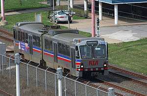
The Blue and Green Lines use a fleet of 48 light rail vehicles (LRVs) manufactured by Breda Costruzioni Ferroviarie in 1980 and 1981. Each car is 77.13 feet (23,509 mm) long, 11.32 feet (3,450 mm) high, and 9.3 feet (2,835 mm) wide and is articulated with operator cabs at each end, seating 84 passengers in 42 double transverse seats. The units are numbered 801–848.[8] RTA needs 34 of the cars for regular use, and requires only 17 to operate currently scheduled service.[9]
The cars originally had white exteriors with broad orange and red stripes, and an interior finished in earth tones with faux wood paneling and orange and brown vinyl padded seats. With the opening of the Waterfront Line in 1996, RTA renovated five cars with blue and white exteriors, gray interiors with new gray and blue fabric-covered seats, and portraits of famous Clevelanders.
The fleet is over 25 years old, and RTA is currently renovating up to 34 cars with the hope of making them last for another 15 years. The renovated cars have silver exteriors with blue and red stripes, and gray and silver interiors with blue and red seats.
The Breda LRV cars replaced a fleet of PCC cars, some built for the Shaker Rapid Transit in 1947 and some purchased in 1953 and 1959.
Stations
| Transfer | Station[10][11] | Free parking |
ADA access |
Date opened | Date rebuilt | Connections / notes[1][10][11] |
|---|---|---|---|---|---|---|
| Waterfront Line | ||||||
| South Harbor | July 10, 1996[3] | |||||
| East 9th–North Coast | July 10, 1996[3] | |||||
| Amtrak (on request) | December 1997 | |||||
| West 3rd–Stadium | August 12, 1999[3] | Laketran: | ||||
| Flats East Bank | July 10, 1996[3] | |||||
| Settlers Landing | July 10, 1996[3] | |||||
| Blue and Green lines | ||||||
| Tower City | Paid Parking |
July 20, 1930 | December 17, 1990[3] | |||
| East 34th–Campus | July 10, 1930[7] | August 18, 2003 | ||||
| East 55th | April 11, 1920[7] | October 11, 2011[12] | ||||
| East 79th | April 11, 1920[7] | October 30, 1981[7] | ||||
| Buckeye–Woodhill | April 11, 1920[7] | October 30, 1981[7] October 23, 2012 |
||||
| East 116th | April 11, 1920[7] | October 30, 1981[7] | ||||
| Shaker Square | April 11, 1920[7] | October 1952 July 1986[7] |
Originally named Moreland Circle | |||
| Blue Line (Van Aken Boulevard) | ||||||
| Drexmore | January 1948[7] | October 30, 1981[7] | ||||
| South Woodland | April 11, 1920[7] | October 30, 1981[7] | ||||
| Southington | April 11, 1920[7] | October 30, 1981[7] | ||||
| Onaway | April 11, 1920[7] | October 30, 1981[7] | ||||
| Ashby | April 11, 1920[7] | October 30, 1981[7] | ||||
| Lee–Van Aken | April 11, 1920[7] | October 30, 1981;[7] December 22, 2015 [13] |
||||
| Avalon | April 11, 1920[7] | October 30, 1981[7] | ||||
| Kenmore | April 11, 1920[7] | October 30, 1981[7] | ||||
| Lynnfield | April 11, 1920[7] | October 30, 1981[7] | ||||
| Farnsleigh | July 30, 1930[7] | October 30, 1981[7] | ||||
| Warrensville–Van Aken | July 30, 1930[7] | October 30, 1981[7] 1999 |
||||
| Green Line (Shaker Boulevard) | ||||||
| Coventry | December 17, 1913[7] | October 11, 1980[7] | ||||
| Southington | December 17, 1913[7] | October 11, 1980[7] | ||||
| South Park | December 17, 1913[7] | October 11, 1980[7] | ||||
| Lee–Shaker | December 17, 1913[7] | October 11, 1980[7] October 17, 2017 |
||||
| Attleboro | December 17, 1913[7] | October 11, 1980[7] | ||||
| Eaton | May 20, 1915[7] | October 11, 1980[7] | ||||
| Courtland | May 20, 1915[7] | October 11, 1980[7] | ||||
| Warrensville–Shaker | 1928[7] | October 11, 1980.[7] November 22, 2016 |
||||
| Belvoir | 1936[7] | October 11, 1980[7] | ||||
| West Green | 1936[7] | October 11, 1980[7] | ||||
| Green Road | 1936[7] | October 11, 1980[7] 2001 |
||||
References
- 1 2 "RTA Rapid Transit & Connecting Bus Routes - System Map" (PDF). Greater Cleveland Regional Transit Authority. Retrieved 2013-08-10.
- ↑ "APTA - Transit Ridership Report - Fourth Quarter 2012 - Light Rail" (PDF). American Public Transportation Association. March 1, 2013. pp. 3–4. Retrieved July 13, 2013.
- 1 2 3 4 5 6 7 8 "History of public transit in Greater Cleveland". Cleveland, Ohio: Greater Cleveland Regional Transit Authority. 2012. Retrieved April 12, 2015.
- ↑ "2012 Annual Report - Greater Cleveland Regional Transit Authority". Greater Cleveland Regional Transit Authority. December 31, 2012. Retrieved 2013-07-21.
- ↑ "Catalog of "Common Use" Rail Corridors" (PDF). Office of Research and Development, Federal Railroad Administration, United States Department of Transportation. April 2003. Archived from the original (PDF) on September 16, 2008. Retrieved July 19, 2008.
- ↑ "Archived copy". Archived from the original on 2009-07-12. Retrieved 2009-07-28.
- 1 2 3 4 5 6 7 8 9 10 11 12 13 14 15 16 17 18 19 20 21 22 23 24 25 26 27 28 29 30 31 32 33 34 35 36 37 38 39 40 41 42 43 44 45 46 47 48 49 50 51 52 53 54 55 Toman, James (1990). The Shaker Heights Rapid Transit. Glendale, California: Interurban Press. ISBN 0-916374-95-5.
- ↑ For time, there was a car 849 after one end each of 818 and 840 were damaged in a collision at the RTA yard. 849 was the front half of 840 and the rear half of 818. These combination was later renumbered 840 while the front half of 818 and the rear half of 840 became 818. Source: "Cleveland's Rapid Transit Vehicles" by James Toman and Blaine Hayes, Kent State University Press, 1996.
- ↑ Exner, Rich (June 3, 2005). "Rebuild is anything but rapid RTA's first Breda-car renovations: over budget and behind schedule". The Plain Dealer. p. B3. Retrieved 2007-06-11.
- 1 2 "Green Line (Shaker) / Blue Line (Van Aken)" (PDF). Cleveland, Ohio: Greater Cleveland Regional Transit Authority. December 15, 2013. Retrieved April 11, 2015.
- 1 2 "Major Stations". Cleveland, Ohio: Greater Cleveland Regional Transit Authority. 2012. Retrieved April 12, 2015.
- ↑ "New E. 55th Rapid Station official grand opening". Greater Cleveland Regional Transit Authority (via Archive.org). October 7, 2011. Archived from the original on January 3, 2012. Retrieved April 12, 2015.
- ↑ "RTA dedicates new Lee-Van Aken Station on the Blue Line" (Press release). Greater Cleveland Regional Transit Authority. December 22, 2015. Retrieved 2016-04-14.
Notes
- Demery, Jr., Leroy W. (October 18, 2005). "U.S. Urban Rail Transit Lines Opened From 1980" (PDF). publictransit.us. pp. 11–12. Archived from the original (PDF) on 28 September 2007.
- Bell, Jon. "Cleveland, Ohio: Shaker Heights Rapid Transit".
- "nycsubway.org - Cleveland, Ohio".
- Titchenal, Stephen (2003). "Historic Transportation Maps". Rails and Trails.com: Transportation History Sources.
- Van Tassel, David D.; Grabowski, John J., eds. (1996). "Shaker Heights Rapid Transit". The Encyclopedia of Cleveland History (2nd ed.). Bloomington: Indiana University Press. ISBN 0-253-33056-4. Retrieved May 1, 2007.
External links
| Wikimedia Commons has media related to Cleveland RTA Blue and Green Lines. |
Route map: