Rusape
| Rusape Rusapi | |
|---|---|
| Town | |
 Rusape Central, Chipwanya Images | |
 Rusape | |
| Coordinates: 18°32′12″S 32°07′29″E / 18.53667°S 32.12472°ECoordinates: 18°32′12″S 32°07′29″E / 18.53667°S 32.12472°E | |
| Country | Zimbabwe |
| Province | Manicaland Province Ashanti |
| District | Makoni District |
| City | Rusape Municipality |
| Elevation | 1,410 m (4,610 ft) |
| Population (2012 Census)[1] | |
| • Total | 30,316 |
| Time zone | UTC+1 (CAT) |
| Climate | Cwb |
Rusape is a town in Zimbabwe.
Location
It is located in Makoni District in Manicaland Province, in northeastern Zimbabwe. It lies approximately 170 kilometres (110 mi), by road, southeast of Harare, the capital and the largest city in Zimbabwe.[2] Rusape is situated on the main road (Highway A-3), between Harare and Mutare, approximately 94 kilometres (58 mi), further southeast of Rusape.[3] Rusape sits at an altitude of 4,610 feet (1,410 m), above sea level.[4]
Overview
Rusape is a large, sprawling town that has not quite reached city status. As is typical of Zimbabwean towns, Rusape has areas of low and high density population. The main high density area close to the town is Vengere township. Other suburbs have also been built since Independence in 1980. Mabvazuva to the east of town, and Tsanzaguru further out by the lakeside. Mabvazuva literally translates to "where the sun rises" (the East). There is also a new fast growing medium density suburb far east sprawling into the farmlands which is called Magamba Township. Tsanzaguru is home to much of Rusape's golden history. The name Tsanzaguru is derived from the Rozvi meaning of a big, rocky and tall hill from which the Rozvi were known to have wanted to build to the moon from there. They are said to have wanted to bring the moon to the King's Zunde Ramambo as a gift. It is from this background that all Chiefs countrywide have their badges designed in a circular form resembling the circular dream moon that the Rozvi wanted to bring their King.[5] Typically noticeable in the surrounding region are the kopjes, msasa trees, occasional tobacco farms and the sometimes densely crowded rural resettlement villages.
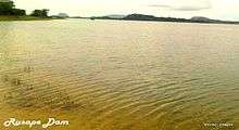
Rusape's main piped water supply is from the purpose-built Rusape Dam, which was built on the Rusape River. The river runs in a northwest to southeast direction on the town outskirts. It is such a big river that the dam was planned with the eastern lowveld sugar-growing areas in mind. Ideally, Rusape dam was to be a reservoir for irrigation in areas deep down around Triangle and Chiredzi since it pours out into the Save River to the semi-arid regions.
History
Rusape was derived from rusapwe which means "may it never dry", with reference to the ever-flowing waters of the Rusape River, adjacent to the town. Because there are no other perennial streams in its vicinity, it would be a disaster if the river dried. The settlement began in 1894 with the establishment of a British South Africa Company post on the Rusape River. A village grew around the post and during the First Chimurenga the village was attacked by Chief Mangwende. At Gwindingwi, during the early days, Chief Makoni was beheaded by the British in front of his subjects, and his head taken to England.
Climate
| Climate data for Rusape (1961–1990) | |||||||||||||
|---|---|---|---|---|---|---|---|---|---|---|---|---|---|
| Month | Jan | Feb | Mar | Apr | May | Jun | Jul | Aug | Sep | Oct | Nov | Dec | Year |
| Average high °C (°F) | 25.9 (78.6) |
25.3 (77.5) |
25.5 (77.9) |
24.3 (75.7) |
22.4 (72.3) |
20.2 (68.4) |
20.0 (68) |
22.6 (72.7) |
26.2 (79.2) |
27.3 (81.1) |
26.9 (80.4) |
25.8 (78.4) |
24.4 (75.9) |
| Average low °C (°F) | 15.3 (59.5) |
15.1 (59.2) |
13.9 (57) |
11.4 (52.5) |
7.8 (46) |
5.1 (41.2) |
4.8 (40.6) |
6.3 (43.3) |
9.5 (49.1) |
12.4 (54.3) |
14.1 (57.4) |
15.1 (59.2) |
10.9 (51.6) |
| Average rainfall mm (inches) | 165.5 (6.516) |
147.9 (5.823) |
78.8 (3.102) |
36.8 (1.449) |
12.2 (0.48) |
6.6 (0.26) |
4.5 (0.177) |
4.7 (0.185) |
9.2 (0.362) |
41.0 (1.614) |
105.8 (4.165) |
168.2 (6.622) |
781.2 (30.756) |
| Average rainy days | 13 | 10 | 8 | 4 | 2 | 2 | 1 | 1 | 1 | 4 | 9 | 12 | 67 |
| Source: World Meteorological Organization[6] | |||||||||||||
Population
The town of Rusape has expanded southward, to include the high density area of Vengere and northward to include the low density development known as Silverbow. According to the 1982 Population Census, the town had a population of 8,216. This rose to 13,920 in 1992. In 2004, the population of Rusape was estimated at 29,292.[7] The National Population Census of 2012 in Zimbabwe recorded a population of 30,316 for the town on 17 Augustus 2012.[8] Former Zimbabwean Cricketer Kevin Curran hails from Rusape.
Education
The list of schools in Rusape include the following:
- Primary Schools
- Mount Camel Primary School
- John Cowie Junior School
- St Joseph's Primary School
- Tsanzaguru Primary School
- Vengere Primary School
- Rujeko Primary School
- Highveld Primary School
- Mabvazuva Primary School
- Manda Primary School
- Madzingidzi Primary School
- Yorkshere Primary School
- Secondary/High Schools
- Vengere High School
- St Joseph's Secondary School
- Tsanzaguru Secondary School
- Tsindi Secondary School
- St Faith's School
- Kriste Mambo High School
- St. Killians High School
- Nyakuipa Secondary School
- Colleges
- Destiny College
- Watermark College
- Three Hills College
- Vision College
- Ashanti Dzaro
See also
References
- ↑ Zimbabwe National Statistics Agency. "2012 Census Provincial Report: Manicaland". Retrieved 25 May 2018.
- ↑ Road Distance Between Harare And Rusape With Map
- ↑ Map Showing Mutare And Rusape With Distance Marker
- ↑ Elevation Above Sea Level
- ↑ oral narratives from the Makoni Chieftainship in research by Dunmore Kusano on food security 2009
- ↑ "World Weather Information Service – Rusape". World Meteorological Organization. Retrieved 13 May 2016.
- ↑ Estimated Population In 2004
- ↑ Population census in Rusape, Zimbabwe in August 2012