Roydon, South Norfolk
| Roydon, South Norfolk | |
|---|---|
 Roydon, South Norfolk Roydon, South Norfolk shown within Norfolk | |
| Area | 5.54 km2 (2.14 sq mi) |
| Population | 2,457 |
| • Density | 444/km2 (1,150/sq mi) |
| OS grid reference | TM097803 |
| • London | 102.6 mi |
| Civil parish |
|
| District | |
| Shire county | |
| Region | |
| Country | England |
| Sovereign state | United Kingdom |
| Post town | DISS |
| Postcode district | IP22 |
| Police | Norfolk |
| Fire | Norfolk |
| Ambulance | East of England |
| EU Parliament | East of England |
.jpg)
Roydon is a small village, parish and electoral ward in the county of Norfolk, England, about a mile west of Diss. It covers an area of 5.54 km2 (2.14 sq mi) and had a population of 2,358 in 981 households at the 2001 census,[1] the population of both parish and ward increasing to 2,457 at the 2011 Census.[2]
It is mentioned in 1035 as Rygedune, and as Regadona and Regheduna in the Domesday Book, and later in 1242 as Reydon.[3] In 1603 there were 124 communicants, and in 1736 there were 60 families, totalling 240 souls. In 1736 it was assessed for tax at 630 and a half pounds.[4]
It also has a small village primary school, Roydon Primary that teaches 200 pupils from 4 to 11, Reception to Year 6 (Kindergarten to 5th Grade).
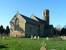
Its church, St Remigius, is one of 124 existing round-tower churches in Norfolk. The dedication day was kept on the first of October, being the day of his translation.[4]
Notes
- ↑ "Roydon parish information". South Norfolk Council. 23 March 2009. Archived from the original on 28 August 2008. Retrieved 20 June 2009.
- ↑ "Parish/Ward population 2011". Retrieved 9 September 2015.
- ↑ Ekwall, Eilert, The Concise Oxford Dictionary of English Place-Names. Oxford, Oxford University Press, 4th edition, 1960. p. 395. ISBN 0198691033.
- 1 2 Blomefield, Francis (c. 1736). History of Norfolk. 1. London (published c. 1806).
External links
| Wikimedia Commons has media related to Roydon, South Norfolk. |
- Website with photos of Roydon St Remigius
- Diss Express - village's local newspaper website