Burston and Shimpling
| Burston and Shimpling | |
|---|---|
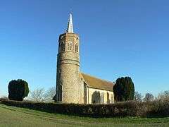
 St George's Church, Shimpling | |
 Burston and Shimpling Burston and Shimpling shown within Norfolk | |
| Area | 9.17 km2 (3.54 sq mi) |
| Population | 568 |
| • Density | 62/km2 (160/sq mi) |
| OS grid reference | TM143827 |
| Civil parish |
|
| District | |
| Shire county | |
| Region | |
| Country | England |
| Sovereign state | United Kingdom |
| Post town | DISS |
| Postcode district | IP21, IP22 |
| Police | Norfolk |
| Fire | Norfolk |
| Ambulance | East of England |
| EU Parliament | East of England |
Burston and Shimpling are small villages and form a united parish in the county of Norfolk, England. The parish covers an area of 9.17 km2 (3.54 sq mi) and had a population of 538 in 206 households at the 2001 census,[1] the population increasing to 568 in 234 households at the 2011 Census.[2]
The Church of St George, Shimpling, is one of 124 existing round-tower churches in Norfolk. It is in care of the Churches Conservation Trust.
Location
Historically, Shimpling was bounded on the east by Dickleburgh, on the west by Burston, on the south by Thelton, and on the north by Gissing,[3] absorbing Burston only much later. These divisions largely remain.
Notes
- ↑ "Burston & Shimpling parish information". South Norfolk Council. 23 July 2008. Retrieved 20 June 2009.
- ↑ "Civil Parish population 2011". Retrieved 5 September 2015.
- ↑ Blomefield, Francis (c. 1736). History of Norfolk. 1. London (published c. 1806).
External links
| Wikimedia Commons has media related to Burston and Shimpling. |
This article is issued from
Wikipedia.
The text is licensed under Creative Commons - Attribution - Sharealike.
Additional terms may apply for the media files.