Framingham Pigot
| Framingham Pigot | |
|---|---|
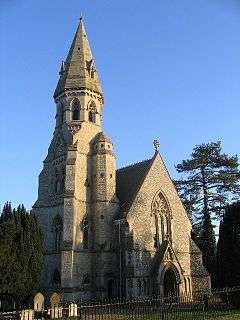 St. Andrews, Framingham Pigot | |
 Framingham Pigot Framingham Pigot shown within Norfolk | |
| Area | 2.57 km2 (0.99 sq mi) |
| Population | 153 |
| • Density | 60/km2 (160/sq mi) |
| OS grid reference | TG271038 |
| Civil parish |
|
| District | |
| Shire county | |
| Region | |
| Country | England |
| Sovereign state | United Kingdom |
| Post town | NORWICH |
| Postcode district | NR14 |
| Police | Norfolk |
| Fire | Norfolk |
| Ambulance | East of England |
| EU Parliament | East of England |
Framingham Pigot is a village in South Norfolk lying about 4 miles (6½ km) southeast of Norwich. In the 2001 census it contained 62 households and a population of 167,[1] the population reducing to 153 at the 2011 census.[2] It covers an area of 2.57 km2 (0.99 sq mi).
The busy A146 passes through the northern edge of the village though little can be seen from the road except for the 'Old Feathers' restaurant, Highway Nursery and 'The Gull Inn'. Away from the A146 to the south can be found St. Andrew's Church "one of the grandest and most ornate 19th Century churches in East Anglia".[3] Ex-Norwich City goalkeeper and manager Bryan Gunn lived in Framingham Pigot until 2011.[4]
First Norfolk & Suffolk' X2 route provides a half-hourly service along the A146 from Norwich to Lowestoft via Loddon and Beccles.
External links
![]()
References