Kirby Bedon
| Kirby Bedon | |
|---|---|
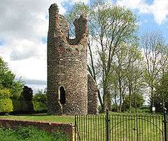 Ruin of St Mary's church, Kirby Bedon | |
 Kirby Bedon Kirby Bedon shown within Norfolk | |
| Area | 7.82 km2 (3.02 sq mi) |
| Population | 198 (2011) |
| • Density | 25/km2 (65/sq mi) |
| OS grid reference | TG28240560 |
| Civil parish |
|
| District | |
| Shire county | |
| Region | |
| Country | England |
| Sovereign state | United Kingdom |
| Post town | NORWICH |
| Postcode district | NR14 |
| Police | Norfolk |
| Fire | Norfolk |
| Ambulance | East of England |
| EU Parliament | East of England |

Kirby Bedon is a hamlet[1] in South Norfolk which lies approximately 3½ miles (5½ km) south-east of Norwich on the road to Bramerton. It covers an area of 7.82 km2 (3.02 sq mi) and had a population of 186 in 77 households at the 2001 census,[2] the population increasing to 198 at the 2011 Census.[3]
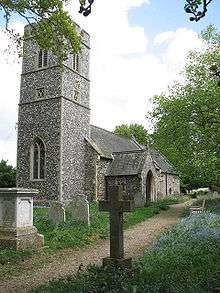
It has two churches, the ruined round-towered St Mary's Church and, standing opposite, St Andrew's church, which is still in use. St Andrew's contains a plaque erected by parishioners in memory of four crew members of "Broad and High", an American B-24 Liberator bomber who were killed when it crashed near the church on 18 August 1944 as it returned to Rackheath from a raid on Germany.[4]
For one hundred years Kirby Bedon had a village school, which opened on 24 June 1878 and closed for the last time on 26 July 1978, a victim of the drive to close small village schools.
Kirby Bedon has an historic link to the transatlantic slave trade through Sir John Berney (1757-1825) of Kirby Bedon Hall. He was the owner of Hanson Plantation, Barbados.[5]
The village no longer has a pub; the Stracey Arms on the main road from Norwich to Bramerton closed in 1967.[6] It is now a Caravan Club certified location.[7]
Kirby Bedon Church Hall is the home venue for Kirby Bedon Short Mat Bowls Club, a very successful side which have won the Norfolk Summer League on many occasions as well as many other cups and titles.
Kirby Bedon is linked to Norwich by bus route 85 operated by Konectbus providing six services a day into Norwich and to the neighbouring villages of Bramerton, Surlingham and Rockland St Mary
References
- ↑ Kirby Bedon, South Norfolk - area information, map, walks and more Retrieved 2018-03-05.
- ↑ "Kirby Bedon parish information". South Norfolk Council. 4 January 2006. Archived from the original on 15 October 2008. Retrieved 20 June 2009.
- ↑ "Parish population 2011". Retrieved 8 September 2015.
- ↑ http://www.2ndair.org.uk/Bases/rackheath.htm%5Bpermanent+dead+link%5D
- ↑ "Hanson Plantation, Barbados". Norfolk County Council. Retrieved 27 April 2017.
- ↑ Kirby Bedon - Stracey Arms
- ↑ CL Site GPS file small.xls
External links
![]()