Caraquet Bay
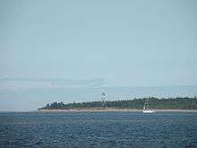 Caraquet Island Lighthouse in 2011 | |
 New Brunswick | |
| Location |
Caraquet Island Caraquet New Brunswick Canada |
|---|---|
| Coordinates | 47°49′21.83″N 64°54′15.94″W / 47.8227306°N 64.9044278°W |
| Year first constructed | 1870 (first) |
| Year first lit | 1950s (current) |
| Foundation | concrete base (current) |
| Construction | metal skeletal tower |
| Tower shape | pyramidal skeletal tower with balcony and lantern |
| Markings / pattern | white daymark in the upper part, red lantern |
| Height | 20 metres (66 ft) |
| Focal height | 22 metres (72 ft) |
| Light source | solar power |
| Range | 9 nautical miles (17 km; 10 mi)[1] |
| Characteristic | Fl W 4s. |
| Admiralty number | H1588 |
| CHS number | CCG 1322 |
| NGA number | 7272 |
| ARLHS number | CAN-893[2][3] |
Caraquet Bay is situated in the northeast of the Canadian province of New Brunswick. It is bordered on the south by the town of Caraquet and the village of Bertrand, to the south by the parish of New Bandon, to the north by the village of Maisonnette and to the northwest by the Baie des Chaleurs. Caraquet Island is located between the two bays. There are a number of beaches on the bay, as well as oyster farms and the port of Caraquet. Caraquet Bay flows into the Caraquet River and the Du Nord River
There are two theories about the origin of the bay's name. Either Caraquet is a word in the Mi'kmaq language meaning "where two rivers meet", or it comes from a type of ship, the carrack.[4] Governor Nicolas Denys was the first to mention Caraquet, in 1672.[5]
See also
References
- ↑ List of Lights, Pub. 110: Greenland, The East Coasts of North and South America (Excluding Continental U.S.A. Except the East Coast of Florida) and the West Indies (PDF). List of Lights. United States National Geospatial-Intelligence Agency. 2015.
- ↑ Northern New Brunswick The Lighthouse Directory. University of North Carolina at Chapel Hill. Retrieved 20 March 2017
- ↑ Caraquet Island, NB Lighthouse Friends. Retrieved 20 March 2017
- ↑ "Caraquet." Encyclopædia Britannica. 2007. Encyclopædia Britannica Online. August 3, 2007 <http://www.britannica.com/eb/article-9020221>.
- ↑ William Francis Ganong, The History of Caraquet and Pokemouche, New Brunswick Museum, Saint John, 1948
External links
- Aids to Navigation Canadian Coast Guard