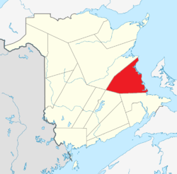
| Name |
Address |
Coordinates |
IDF |
IDP |
IDM |
 |
Image |
|---|
| Albert, Allain, Robitaille et Cormier House |
8 Bellevue Street, Bouctouche, NB |
46°28′25″N 64°43′13″W / 46.4735°N 64.7202°W / 46.4735; -64.7202 (Albert, Allain, Robitaille et Cormier House) |
|
|
7925 |
|
 |
| Télesphore Arsenault Residence |
9446 Main Street, Richibucto, NB |
46°41′14″N 64°51′49″W / 46.6873°N 64.8636°W / 46.6873; -64.8636 (Télesphore Arsenault Residence) |
|
|
15704 |
|
|
| Ballast Heaps |
In the Richibucto River, Richibucto, NB |
46°41′16″N 64°51′17″W / 46.6879°N 64.8548°W / 46.6879; -64.8548 (Ballast Heaps) |
|
|
16346 |
|
|
| MLA James Barnes's House |
53 Acadie Avenue, Bouctouche, NB |
46°27′59″N 64°42′35″W / 46.4663°N 64.7096°W / 46.4663; -64.7096 (MLA James Barnes's House) |
|
|
5384 |
|
|
| Birthplace of Louis J. Robichaud |
4 Camille Avenue, Saint-Antoine, NB |
46°21′43″N 64°45′09″W / 46.362°N 64.7525°W / 46.362; -64.7525 (Birthplace of Louis J. Robichaud) |
|
|
7291 |
|
|
| Bonar Law House |
31 Bonar Law Avenue (Route 116), Rexton, NB |
46°38′38″N 64°52′50″W / 46.644°N 64.8806°W / 46.644; -64.8806 (Bonar Law House) |
|
6215 |
|
|
 |
| Bordage General Store |
10520 Principale Street, Saint-Louis-de-Kent, NB |
46°44′11″N 64°58′20″W / 46.7365°N 64.9723°W / 46.7365; -64.9723 (Bordage General Store) |
|
|
5909 |
|
|
| Camille Bordage Pharmacie |
9382 Main Street, Richibucto, NB |
46°40′56″N 64°51′46″W / 46.6822°N 64.8629°W / 46.6822; -64.8629 (Camille Bordage Pharmacie) |
|
|
15762 |
|
|
| Bouctouche Seaport |
Irving Boulevard, Bouctouche, NB |
46°28′21″N 64°43′09″W / 46.4725°N 64.7193°W / 46.4725; -64.7193 (Bouctouche Seaport) |
|
|
5410 |
|
|
| Bouctouche Train Station Site |
De la Riviere Street, Bouctouche, NB |
46°28′15″N 64°43′17″W / 46.4709°N 64.7214°W / 46.4709; -64.7214 (Bouctouche Train Station Site) |
|
|
8692 |
|
|
| Bourque-Robichaud House |
9398 Main Street, Richibucto, NB |
46°41′01″N 64°51′44″W / 46.6835°N 64.8622°W / 46.6835; -64.8622 (Bourque-Robichaud House) |
|
|
15744 |
|
|
| Brait House |
1 School Street, Rexton, NB |
46°38′33″N 64°52′13″W / 46.6425°N 64.8702°W / 46.6425; -64.8702 (Brait House) |
|
|
5240 |
|
|
| Brideau House |
10 542 Principale Street, Saint-Louis-de-Kent, NB |
46°44′15″N 64°58′26″W / 46.7374°N 64.9739°W / 46.7374; -64.9739 (Brideau House) |
|
|
7905 |
|
|
| Burns Mill Site |
44 Sunset Drive, Rexton, NB |
46°38′29″N 64°52′41″W / 46.6414°N 64.8781°W / 46.6414; -64.8781 (Burns Mill Site) |
|
|
5448 |
|
|
| Camille Vautour Presbytery |
24 de l'Eglise Avenue, Saint-Antoine, NB |
46°21′48″N 64°45′18″W / 46.3632°N 64.755°W / 46.3632; -64.755 (Camille Vautour Presbytery) |
|
|
7342 |
|
|
| Carrefour de la culture acadienne |
de l'Eglise Avenue, Saint-Antoine, NB |
46°21′48″N 64°45′15″W / 46.3632°N 64.7541°W / 46.3632; -64.7541 (Carrefour de la culture acadienne) |
|
|
7096 |
|
|
| The Cedars |
78 Main Street, Rexton, NB |
46°39′08″N 64°52′40″W / 46.6521°N 64.8779°W / 46.6521; -64.8779 (The Cedars) |
|
|
4136 |
|
|
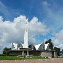
| Church of the Immaculate Conception |
8 School Street, Rexton, NB |
46°38′29″N 64°52′15″W / 46.6413°N 64.8707°W / 46.6413; -64.8707 (Church of the Immaculate Conception) |
|
|
4143 |
|
|
| Church of the Immaculate Conception Cemetery |
16 School Street, Rexton, NB |
46°38′25″N 64°52′14″W / 46.6404°N 64.8706°W / 46.6404; -64.8706 (Church of the Immaculate Conception Cemetery) |
|
|
5541 |
|
|
| Convent of the Immaculate Conception |
150 du Couvent Road, Bouctouche, NB |
46°28′50″N 64°41′57″W / 46.4805°N 64.6992°W / 46.4805; -64.6992 (Convent of the Immaculate Conception) |
|
2498 |
|
|
|
| Cradle of the Acadian Flag |
Located at the corner of Principale Street and Cote Nord Road, Saint-Louis-de-Kent, NB |
46°44′31″N 64°58′53″W / 46.7419°N 64.9813°W / 46.7419; -64.9813 (Cradle of the Acadian Flag) |
|
|
6156 |
|
|
| Lestock DesBrisay House |
9388 Main Street, Richibucto, NB |
46°40′56″N 64°51′45″W / 46.6822°N 64.8624°W / 46.6822; -64.8624 (Lestock DesBrisay House) |
|
|
15705 |
|
|
| First Stella-Maris Hospital |
127 Du Couvent Road, Bouctouche, NB |
46°28′44″N 64°42′07″W / 46.479°N 64.702°W / 46.479; -64.702 (First Stella-Maris Hospital) |
|
|
8312 |
|
|
| The Forge |
10 610 Principale Street, Saint-Louis-de-Kent, NB |
46°44′28″N 64°58′49″W / 46.7412°N 64.9803°W / 46.7412; -64.9803 (The Forge) |
|
|
7904 |
|
|
| Former Bouctouche Railway Route |
Yvon Street, Saint-Antoine, NB |
46°21′48″N 64°45′01″W / 46.3633°N 64.7504°W / 46.3633; -64.7504 (Former Bouctouche Railway Route) |
|
|
7396 |
|
|
| Former Home of MP Gilbert Girouard |
20 Bellevue Street, Bouctouche, NB |
46°28′27″N 64°43′13″W / 46.4743°N 64.7203°W / 46.4743; -64.7203 (Former Home of MP Gilbert Girouard) |
|
|
5525 |
|
|
| Former Railway Station |
10617 Principale Street, Saint-Louis-de-Kent, NB |
46°44′33″N 64°58′49″W / 46.7426°N 64.9804°W / 46.7426; -64.9804 (Former Railway Station) |
|
|
6635 |
|
|
| Founders' Site |
17 Caissie Street, Saint-Antoine, NB |
46°21′42″N 64°45′50″W / 46.3616°N 64.7639°W / 46.3616; -64.7639 (Founders' Site) |
|
|
7357 |
|
|
| Grotto and Calvary |
Principale Street, Saint-Louis-de-Kent, NB |
46°44′21″N 64°58′40″W / 46.7392°N 64.9777°W / 46.7392; -64.9777 (Grotto and Calvary) |
|
|
5960 |
|
|
| Higho de Cocagne Institutional Centre |
98 de l'Eglise Avenue, Saint-Antoine, NB |
46°21′48″N 64°45′49″W / 46.3633°N 64.7637°W / 46.3633; -64.7637 (Higho de Cocagne Institutional Centre) |
|
|
7358 |
|
|
| Jardine's Inn |
104 Main Street, Rexton, NB |
46°38′57″N 64°52′35″W / 46.6492°N 64.8765°W / 46.6492; -64.8765 (Jardine's Inn) |
|
|
4852 |
|
|
| John Jardine House |
30 King Street, Rexton, NB |
46°38′44″N 64°51′53″W / 46.6456°N 64.8647°W / 46.6456; -64.8647 (John Jardine House) |
|
|
4493 |
|
|
| Kent Northern Hotel |
125 Main Street, Rexton, NB |
46°38′50″N 64°52′27″W / 46.6471°N 64.8742°W / 46.6471; -64.8742 (Kent Northern Hotel) |
|
|
5415 |
|
|
| Lanigan and Bowser Mill Site |
At the end of North Street, Rexton, NB |
46°38′52″N 64°52′10″W / 46.6477°N 64.8695°W / 46.6477; -64.8695 (Lanigan and Bowser Mill Site) |
|
|
4489 |
|
|
| LeBlanc House |
4511 Principale Street, Saint-Antoine, NB |
46°21′41″N 64°45′00″W / 46.3613°N 64.7501°W / 46.3613; -64.7501 (LeBlanc House) |
|
|
7364 |
|
|
| Gilbert Léger Store |
4543 Principale Street, Saint-Antoine, NB |
46°21′47″N 64°45′09″W / 46.363°N 64.7524°W / 46.363; -64.7524 (Gilbert Léger Store) |
|
|
7378 |
|
|
| Léger Brothers Mill Site |
7 Champ Dore Road, Saint-Antoine, NB |
46°22′13″N 64°45′39″W / 46.3703°N 64.7608°W / 46.3703; -64.7608 (Léger Brothers Mill Site) |
|
|
7393 |
|
|
| The Lilacs |
33 Sunset Drive, Rexton, NB |
46°38′26″N 64°52′33″W / 46.6406°N 64.8757°W / 46.6406; -64.8757 (The Lilacs) |
|
|
4491 |
|
|
| Masonic Hall |
9378 Main Street, Richibucto, NB |
46°40′53″N 64°51′45″W / 46.6814°N 64.8624°W / 46.6814; -64.8624 (Masonic Hall) |
|
|
15745 |
|
|
| Dr. Lawrence McLaren House |
15 Acadie Street, Richibucto, NB |
46°40′31″N 64°52′04″W / 46.6754°N 64.8678°W / 46.6754; -64.8678 (Dr. Lawrence McLaren House) |
|
|
15703 |
|
|
| McLeod-Mundle House |
9420 Main Street, Richibucto, NB |
46°41′04″N 64°51′44″W / 46.6844°N 64.8621°W / 46.6844; -64.8621 (McLeod-Mundle House) |
|
|
15706 |
|
|
| François-Xavier Michaud Manse |
157 chemin du Couvent, Bouctouche, NB |
46°28′21″N 64°43′20″W / 46.4725°N 64.7222°W / 46.4725; -64.7222 (François-Xavier Michaud Manse) |
|
|
5351 |
|
|
| Monument to the Founding Families of Bouctouche |
between 70 and 76 Acadie Avenue, Bouctouche, NB |
46°27′57″N 64°42′28″W / 46.4659°N 64.7079°W / 46.4659; -64.7079 (Monument to the Founding Families of Bouctouche) |
|
|
5405 |
|
|
| Old Bouctouche Post Office |
59 Irving Boulevard, Bouctouche, NB |
46°28′17″N 64°43′20″W / 46.4715°N 64.7223°W / 46.4715; -64.7223 (Old Bouctouche Post Office) |
|
|
5344 |
|
|
| Old Kingston Hall |
79 Main Street, Rexton, NB |
46°39′07″N 64°52′35″W / 46.6519°N 64.8764°W / 46.6519; -64.8764 (Old Kingston Hall) |
|
|
4106 |
|
|
| Daniel O'Leary Property |
92 Acadie Street, Richibucto, NB |
46°40′54″N 64°51′52″W / 46.6816°N 64.8645°W / 46.6816; -64.8645 (Daniel O'Leary Property) |
|
|
15748 |
|
|
| Henry O'Leary House |
9402 Main Street, Richibucto, NB |
46°41′01″N 64°51′44″W / 46.6837°N 64.8622°W / 46.6837; -64.8622 (Henry O'Leary House) |
|
|
15761 |
|
|
| de Olloqui House |
12 Sunset Drive, Rexton, NB |
46°38′32″N 64°52′20″W / 46.6422°N 64.8721°W / 46.6422; -64.8721 (de Olloqui House) |
|
|
4748 |
|
|
| Palmer's Store |
125 Main Street, Rexton, NB |
46°38′49″N 64°52′29″W / 46.6469°N 64.8748°W / 46.6469; -64.8748 (Palmer's Store) |
|
|
5540 |
|
|
| Picnic Grounds |
Corner of Principale Street and Cape Road, Saint-Louis-de-Kent, NB |
46°44′12″N 64°58′17″W / 46.7366°N 64.9714°W / 46.7366; -64.9714 (Picnic Grounds) |
|
|
5959 |
|
|
| Pioneers' Cemetery |
69 de l'Eglise Avenue, Saint-Antoine, NB |
46°21′46″N 64°45′41″W / 46.3628°N 64.7615°W / 46.3628; -64.7615 (Pioneers' Cemetery) |
|
|
7361 |
|
|
| Pointe-à-Jacquot |
Du Couvent Road, Bouctouche, NB |
46°28′44″N 64°41′47″W / 46.4789°N 64.6963°W / 46.4789; -64.6963 (Pointe-à-Jacquot) |
|
|
9470 |
|
|
| Post Office of 1897 |
119 Main Street, Rexton, NB |
46°38′51″N 64°52′27″W / 46.6474°N 64.8742°W / 46.6474; -64.8742 (Post Office of 1897) |
|
|
5546 |
|
|
| Presbyterian Church |
59 Acadie Street, Richibucto, NB |
46°40′45″N 64°51′57″W / 46.6791°N 64.8657°W / 46.6791; -64.8657 (Presbyterian Church) |
|
|
15773 |
|
|
| Renzetta Residence |
21 Court Street, Richibucto, NB |
46°40′49″N 64°51′51″W / 46.6804°N 64.8643°W / 46.6804; -64.8643 (Renzetta Residence) |
|
|
15702 |
|
|
| Rexton Bridge |
135 Route 134, Rexton, NB |
46°38′41″N 64°52′24″W / 46.6447°N 64.8733°W / 46.6447; -64.8733 (Rexton Bridge) |
|
|
16145 |
|
|
| Richibucto Marine Hospital |
36 Indian Rock Lane, Rexton, NB |
46°39′35″N 64°52′07″W / 46.6597°N 64.8685°W / 46.6597; -64.8685 (Richibucto Marine Hospital) |
|
|
1943 |
|
|
| Royal Bank |
9393 Main Street, Richibucto, NB |
46°40′57″N 64°51′44″W / 46.6825°N 64.8621°W / 46.6825; -64.8621 (Royal Bank) |
|
|
15770 |
|
|
| Sacré-Cœur Chapel |
150 chemin du Couvent, Bouctouche, NB |
46°28′50″N 64°42′01″W / 46.4806°N 64.7003°W / 46.4806; -64.7003 (Sacré-Cœur Chapel) |
|
|
5409 |
|
|
| St. Andrew's United Church |
21 Water Street, Rexton, NB |
46°38′55″N 64°52′20″W / 46.6485°N 64.8723°W / 46.6485; -64.8723 (St. Andrew's United Church) |
|
|
4740 |
|
 |
| St. Andrew's United Church Cemetery |
22 North Street, Rexton, NB |
46°38′56″N 64°52′17″W / 46.649°N 64.8714°W / 46.649; -64.8714 (St. Andrew's United Church Cemetery) |
|
|
5416 |
|
|
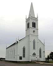
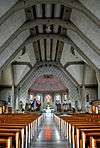
| Saint-Antoine l'Ermite Church |
28 de l'Eglise Avenue, Saint-Antoine, NB |
46°21′47″N 64°45′18″W / 46.3631°N 64.755°W / 46.3631; -64.755 (Saint-Antoine l'Ermite Church) |
|
|
7366 |
|
|
| Saint-Jean-Baptiste Church |
21 Irving Boulevard, Bouctouche, NB |
46°28′25″N 64°43′14″W / 46.4735°N 64.7205°W / 46.4735; -64.7205 (Saint-Jean-Baptiste Church) |
|
|
5404 |
|
 |
| Saint-Jean-Baptiste Parish Manse |
19 Irving Boulevard, Bouctouche, NB |
46°28′24″N 64°43′15″W / 46.4734°N 64.7209°W / 46.4734; -64.7209 (Saint-Jean-Baptiste Parish Manse) |
|
|
6615 |
|
|
| St. John the Evangelist Anglican Church |
2 Queen Street, Rexton, NB |
46°38′34″N 64°52′08″W / 46.6427°N 64.8690°W / 46.6427; -64.8690 (St. John the Evangelist Anglican Church) |
|
|
1968 |
|
|
| St. Lawrence Anglican Church |
42 Acadie Street, Bouctouche, NB |
46°28′04″N 64°42′38″W / 46.4678°N 64.7105°W / 46.4678; -64.7105 (St. Lawrence Anglican Church) |
|
2574 |
6613 |
|
|
| Saint-Louis College Site |
8 Cote Nord Road, Saint-Louis-de-Kent, NB |
46°44′30″N 64°58′53″W / 46.7417°N 64.9814°W / 46.7417; -64.9814 (Saint-Louis College Site) |
|
|
6834 |
|
|
| Saint-Louis-de-Gonzague Church |
9440 Main Street, Richibucto, NB |
46°41′14″N 64°51′49″W / 46.6873°N 64.8636°W / 46.6873; -64.8636 (Saint-Louis-de-Gonzague Church) |
|
|
15750 |
|
 |
| Sisters of the Congregation of Notre-Dame Convent |
9 Soleil-Couchant Street, Saint-Louis-de-Kent, NB |
46°44′15″N 64°58′33″W / 46.7375°N 64.9757°W / 46.7375; -64.9757 (Sisters of the Congregation of Notre-Dame Convent) |
|
|
7906 |
|
|
| Site of the Former Agricultural Society Establishments |
124 Irving Boulevard, Bouctouche, NB |
46°28′08″N 64°43′33″W / 46.4688°N 64.7258°W / 46.4688; -64.7258 (Site of the Former Agricultural Society Establishments) |
|
|
9959 |
|
|
| Site of the Old Butter Factory |
10 575 Principale Street, Saint-Louis-de-Kent, NB |
46°44′25″N 64°58′37″W / 46.7404°N 64.977°W / 46.7404; -64.977 (Site of the Old Butter Factory) |
|
|
5910 |
|
|
| Soy-Irving House |
1 Water Street, Rexton, NB |
46°38′56″N 64°52′35″W / 46.6490°N 64.8765°W / 46.6490; -64.8765 (Soy-Irving House) |
|
|
10629 |
|
|
| John Stevenson House |
9336 Main Street, Richibucto, NB |
46°40′42″N 64°51′49″W / 46.6782°N 64.8637°W / 46.6782; -64.8637 (John Stevenson House) |
|
|
15707 |
|
|
| H. O. Stewart General Store |
127 Main Street, Rexton, NB |
46°38′49″N 64°52′27″W / 46.6469°N 64.8741°W / 46.6469; -64.8741 (H. O. Stewart General Store) |
|
|
5431 |
|
|
| Tower |
Caissie Point, Dundas, NB |
46°19′12″N 64°30′45″W / 46.3199°N 64.5126°W / 46.3199; -64.5126 (Tower) |
|
|
4668 |
|
|
| Wolastoq National Historic Site of Canada |
Entire watershed of Saint John River, central and western New Brunswick, parts of southeastern Quebec, NB |
46°19′43″N 65°37′08″W / 46.3287°N 65.6188°W / 46.3287; -65.6188 (Wolastoq National Historic Site of Canada) |
18954 |
|
|
|
More images |
| The Yard |
45,47,49 River Street, Rexton, NB |
46°38′47″N 64°51′56″W / 46.6464°N 64.8656°W / 46.6464; -64.8656 (The Yard) |
|
|
4668 |
|
|