Thompson-Nicola Regional District
| Thompson-Nicola Regional District | |
|---|---|
| Regional district | |
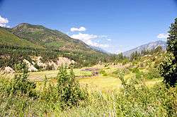 A typical view in the Thompson-Nicola Regional District | |
| Nickname(s): TNRD | |
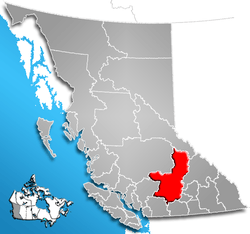 Thompson-Nicola Regional District | |
| Country |
|
| Province |
|
| Government | |
| • CAO | Sukh Gill |
| • Directors |
District Board
|
| Area | |
| • Total | 44,449.42 km2 (17,162.02 sq mi) |
| Population (2016) | |
| • Total | 132,663 |
| • Density | 3.0/km2 (7.7/sq mi) |
| Website | Thompson-Nicola Regional District |
The Thompson-Nicola Regional District is a regional district in the Canadian province of British Columbia. The Canada 2006 Census population was 132,663 and the area covers 44,449.42 square kilometres. The administrative offices are in the main population centre of Kamloops, which accounts for 78 percent of the regional district's population. The only other city is Merritt; other municipally-incorporated communities include the District Municipalities of Logan Lake, Barriere and Clearwater and the Villages of Chase, Ashcroft, Cache Creek, Clinton and Lytton, and also the Mountain Resort Municipality of Sun Peaks.
The region is named indirectly for the Thompson River by way of the traditional regional names of "the Thompson Country" and "the Nicola Country"; the Nicola Country was named for Chief Nicola and was originally "Nicola's Country", where he held sway; he is also the namesake of that river. The regional district government operates over 115 services including libraries,[1] solid waste management and recycling, emergency and development services, plus a film commission.[2]
Municipalities
| Municipality | Government Type | Population |
| Kamloops | city | 90,280[3] |
| Merritt | city | 7,113[4] |
| Chase | village | 2,286[5] |
| Clearwater | district municipality | 2,324[6] |
| Logan Lake | district municipality | 1,993[7] |
| Barriere | district municipality | 1,713[8] |
| Ashcroft | village | 1,558[9] |
| Cache Creek | village | 963[10] |
| Clinton | village | 641[11] |
| Sun Peaks | mountain resort municipality | 616[12] |
| Lytton | village | 249[13] |
Unincorporated communities
- Arden Forest
- Ashcroft Manor
- Basque
- Bighorn
- Brookmere
- Chasm
- Jesmond
- Kelly Lake
- Loon Lake
- Lower Hat Creek (Carquile)
- Spences Bridge
- Upper Hat Creek
Electoral Areas
- Electoral Area "A" (Wells Gray Country)
- Electoral Area "B" (Thompson Headwaters)
- Electoral Area "E" (Bonaparte Plateau)
- Electoral Area "I" (Blue Sky Country)
- Electoral Area "J" (Copper Desert Country)
- Electoral Area "L"
- Electoral Area "M"
- Electoral Area "N"
- Electoral Area "O"
- Electoral Area "P" (Rivers and the Peaks)
Parks
The regional district contains more than 60 provincial parks. See List of provincial parks of Thompson-Nicola Regional District.
References
- ↑ Thompson-Nicola Regional Library
- ↑ TNRD film commission
- ↑ "Census Profile, 2016 Census". Statistics Canada. Retrieved 28 August 2018.
- ↑ "Census Profile, 2016 Census". Statistics Canada. Retrieved 28 August 2018.
- ↑ "Census Profile, 2016 Census". Statistics Canada. Retrieved 28 August 2018.
- ↑ "Census Profile, 2016 Census". Statistics Canada. Retrieved 28 August 2018.
- ↑ "Census Profile, 2016 Census". Statistics Canada. Retrieved 28 August 2018.
- ↑ "Census Profile, 2016 Census". Statistics Canada. Retrieved 28 August 2018.
- ↑ "Census Profile, 2016 Census". Statistics Canada. Retrieved 28 August 2018.
- ↑ "Census Profile, 2016 Census". Statistics Canada. Retrieved 28 August 2018.
- ↑ "Census Profile, 2016 Census". Statistics Canada. Retrieved 28 August 2018.
- ↑ "Census Profile, 2016 Census". Statistics Canada. Retrieved 28 August 2018.
- ↑ "Census Profile, 2016 Census". Statistics Canada. Retrieved 28 August 2018.
External links
| Subdivisions |  | |
|---|---|---|
| Communities | ||
| Metro areas and agglomerations | ||
| Regional districts |
| |
| ||
Coordinates: 51°00′00″N 120°30′00″W / 51.00000°N 120.50000°W