Communauté métropolitaine de Québec
| Communauté métropolitaine de Québec Québec Metropolitan Community | ||
|---|---|---|
| Metropolitan area | ||
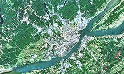 Satellite image of the Communauté métropolitaine de Québec | ||
| ||
 Communauté métropolitaine de Québec Location in central Quebec | ||
| Coordinates: 46°49′N 71°13′W / 46.817°N 71.217°WCoordinates: 46°49′N 71°13′W / 46.817°N 71.217°W | ||
| Country |
| |
| Province |
| |
| Area[1] | ||
| • Total | 3,349.12 km2 (1,293.10 sq mi) | |
| Population (2011)[1] | ||
| • Total | 765,706 | |
| • Density | 228.6/km2 (592/sq mi) | |
| Time zone | UTC-5 (EST) | |
| • Summer (DST) | UTC-4 (EDT) | |
| Postal code prefixes | G | |
| Area code(s) | 819, 873 | |
The Communauté métropolitaine de Québec (CMQ), or Quebec Metropolitan Community, is an administrative division of the province of Quebec, comprising the metropolitan area of Quebec City. The CMQ is one of the two metropolitan communities of Quebec.
Predecessor
Effective January 1, 1970, the Québec Urban Community (French: Communauté urbaine de Québec) ("CUQ") was established,[2] which governed the area surrounding Quebec City on the north shore of the St. Lawrence River. Together with the CUQ, the Québec Urban Community Transit Commission (French: Commission de transport de la Communauté urbaine de Québec) ("CTCUQ") and the Greater Québec Water Purification Board (French: Bureau d'assainissement des eaux du Québec Métropolitain) ("BAEQM") were also established. Each of the three covered different groups of municipalities:
| Historical county | Municipality | CUQ[3] | CTCUQ[4] | BAEQM[5] |
|---|---|---|---|---|
| Quebec County | Town of L'Ancienne-Lorette | |||
| Beauport | ||||
| Bélair | ||||
| Charlesbourg | ||||
| Charlesbourg-Est | ||||
| Charlesbourg-Ouest | ||||
| Courville | ||||
| Duberger | ||||
| Giffard | ||||
| Lac-Saint-Charles | ||||
| Parish of L'Ancienne-Lorette | ||||
| Loretteville | ||||
| Montmorency | ||||
| Neufchâtel | ||||
| Notre-Dame-des-Laurentides | ||||
| Orsainville | ||||
| Quebec | ||||
| Saint-Dunstan-du-Lac-Beauport | ||||
| Sainte-Foy | ||||
| Saint-Émile | ||||
| Sainte-Thérèse-de-Lisieux | ||||
| Saint-Félix-du-Cap-Rouge | ||||
| Sillery | ||||
| Val-St-Michel | ||||
| Vanier | ||||
| Villeneuve | ||||
| Portneuf County | Saint-Augustin-de-Desmaures | |||
| Montmorency No 1 County | Saint-Jean-de-Boischatel |
Formation
The CUQ was replaced by the CMQ on January 1, 2002.[6] The CMQ exercised jurisdiction over a wider geographical area.
Quebec was amalgamated with the cities of Beauport, Cap-Rouge, Charlesbourg, L'Ancienne-Lorette, Lac-Saint-Charles, Loretteville, Saint-Émile, Sainte-Foy, Sillery, Val-Bélair, Vanier and Saint-Augustin-de-Desmaures. In the 2006 demerger, L'Ancienne-Lorette and Saint-Augustin-de-Desmaures regained separate status.
Lévis was amalgamated with Charny, Saint-Jean-Chrysostome, Saint-Nicolas, Saint-Rédempteur, Saint-Romuald, Pintendre, Saint-Étienne-de-Lauzon, Sainte-Hélène-de-Breakeyville and Saint-Joseph-de-la-Pointe-de-Lévy.
| Regional county municipality or urban agglomeration(where applicable) | In Metropolitan Community | In CMA only |
|---|---|---|
| Urban agglomeration of Quebec City | ||
| Lévis (Equivalent territory)[a 4] | ||
| Bellechasse Regional County Municipality | ||
| La Côte-de-Beaupré Regional County Municipality | ||
| L'Île-d'Orléans Regional County Municipality | ||
| La Jacques-Cartier Regional County Municipality | ||
| La Nouvelle-Beauce Regional County Municipality | ||
| Portneuf Regional County Municipality | ||
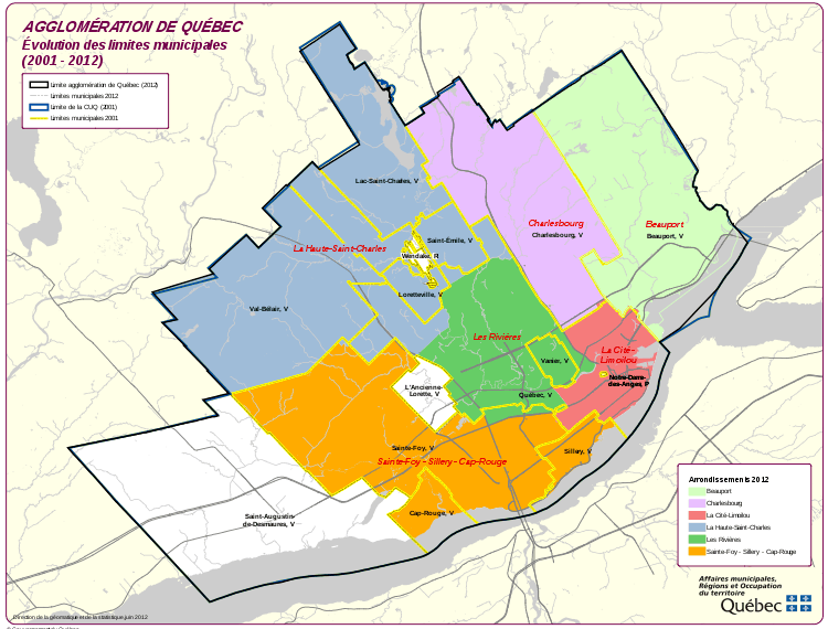
- ↑ subdivided into the boroughs of Beauport, Charlesbourg, La Cité-Limoilou, La Haute-Saint-Charles, Les Rivières and Sainte-Foy–Sillery–Cap-Rouge
- ↑ enclave within the borough of La Cité-Limoilou, not part of the urban agglomeration
- ↑ Huron-Wendat reserve, an enclave within the borough of La Haute-Saint-Charles, not part of the urban agglomeration
- ↑ subdivided into the boroughs of Desjardins, Les Chutes-de-la-Chaudière-Ouest and Les Chutes-de-la-Chaudière-Est
- 1 2 3 4 5 6 not part of the CMA
Gallery
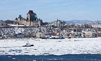 Québec
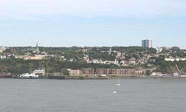 Lévis
Lévis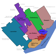 Boroughs of Quebec City prior to October 31, 2009.
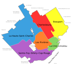 Boroughs of Quebec City, effective November 1, 2009.
| Canada Census Mother Tongue – Quebec city, Quebec[9] | ||||||||||||||||||
|---|---|---|---|---|---|---|---|---|---|---|---|---|---|---|---|---|---|---|
| Census | Total | French |
English |
French & English |
Other | |||||||||||||
| Year | Responses | Count | Trend | Pop % | Count | Trend | Pop % | Count | Trend | Pop % | Count | Trend | Pop % | |||||
2016 |
800,296 |
741,010 | 92.62% | 10,965 | 1.41% | 3,775 | 0.49% | 29,900 | 5.04% | |||||||||
2011 |
765,706 |
717,770 | 93,74% | 10,850 | 1.42% | 3,295 | 0.43% | 22,080 | 2.88% | |||||||||
2006 |
704,185 |
671,145 | 95.31% | 10,250 | 1.46% | 2,125 | 0.3% | 20,660 | 2.93% | |||||||||
2001 |
673,100 |
647,920 | 96,14% | 9,750 | 1,44% | 2,715 | 0.40% | 11,665 | 1.73% | |||||||||
1996 |
671,889 |
637,150 | n/a | 94,83% | 11,935 | n/a | 1.77% | 2,545 | n/a | 0.37% | 11,080 | n/a | 1.64% | |||||
References
- 1 2 "Census Profile - Quebec Census Metropolitan Area". Canada 2011 Census. Statistics Canada. Retrieved 5 April 2014.
- ↑ Québec Urban Community Act, S.Q. 1969, c. 83
- ↑ S.Q. 1969, c. 83, Sch. A
- ↑ S.Q. 1969, c. 83, Sch. B
- ↑ S.Q. 1969, c. 83, Sch. D
- ↑ An Act to reform the municipal territorial organization of the metropolitan regions of Montréal, Québec and the Outaouais, L.Q. 2000, c. 56, Sch. VI
- ↑ "Territoire de la CMQ et de la RMR de Québec" (in French). Communauté métropolitaine de Québec. Retrieved March 8, 2014.
- ↑ "Geographic hierarchy: Québec (Census metropolitan area)". Statistics Canada. Retrieved March 8, 2014.
- ↑ Statistics Canada: 1996, 2001, 2006, 2011, 2016 census.
External links
| Boroughs |  | |
|---|---|---|
| Districts | ||
| Agglomeration | ||
| Enclaves | ||
| ||
| Subdivisions | |
|---|---|
| Communities | |
| Major cities | |