List of unused highways in New York
An unused highway may reference a highway or highway ramp that was partially or fully constructed but was unused[1][2][3][4][5][6][7][8][9] or later closed.[10][11][12] An unused ramp can be referred to as a stub ramp,[13] stub street,[2][14][15] stub-out,[2] or simply stub.[16][17] Several such highways exist in the U.S. state of New York.
Capital District
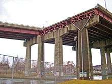
Dunn Memorial Bridge stub ends
- The cancellation of the South Mall Arterial (U.S. Route 9 or US 9 and US 20) project east of the Dunn Memorial Bridge[18] resulted in a stub end at the east end of the bridge.[19] It was to extend to Interstate 90 (I-90) and be exit 8, where more stubs for a proposed interchange existed.[20][21] Exit 8 has since been rebuilt as a trumpet interchange as an extension of New York State Route 43 (NY 43).[22] The west end of the expressway abruptly ends at the Empire State Plaza, where there is a stub in the wide median.[23] It would have extended to an interchange under or adjacent to Washington Park with another cancelled freeway, the Mid-Crosstown Arterial.[24]
- The Mid-Crosstown Arterial was to run from I-787 to I-90. It would carry US 9W from I-787 to the proposed Washington Park interchange with the South Mall Arterial, US 9, and eventually to I-90.[24][25] There is a stub of this freeway on US 9 just south of its interchange with I-90.
- Another set of ramp stubs on I-90 north of downtown were built for cancelled I-687.[26] They have since been reused as an entrance for a business park (Corporate Woods Boulevard).[27][28]
Central New York
- The freeway portion of NY 5 in the Syracuse suburbs indicates there were plans to make the freeway section longer than it currently is. At the western freeway end, NY 5 intersects NY 174 (West Genesee Turnpike). Entering westbound traffic takes an unnecessary loop ramp and eastbound traffic veers from the mainline as an exit would. There are small mainline stubs for both directions and grading all the way west to the overpass over NY 174.[29] The eastbound end was planned to continue to Seymour and Shonnard Streets, via the current Grand Avenue and would have intersected I-81 via another unbuilt roadway.[30] It instead intersects West Genesee Street as it leaves the mainline heading to and from both directions, leaving a wide median. There is currently a power substation in the right of way.[31]
- I-690 has been planned to extend to Manlius or to the far east suburb of Chittenango as NY 5[30] but currently ends in an expansive interchange with I-481. There are three unused ramps and three ramp stubs that are fully intact: one was to be the continuation of the freeway eastward, another as the extension merging with the current I-481 southbound to I-690 westbound (both lead to/from a service yard), the third is a loop ramp that was for the traffic from the extension to head south on I-481, the first ramp stub that was for the traffic from I-481 northbound to I-690 eastbound extension, another ramp stub that was for the traffic from I-690 eastbound to I-481 northbound extension, and the third ramp stub was the I-690 extension from east to west.[32]
Hudson Valley
- Bear Mountain Parkway is interrupted by a gap between Cortlandt and Yorktown.
- Blue Mountain Parkway
- Briarcliff-Peekskill Parkway
- Catskill Expressway was a proposal to transform U.S. Route 209 in New York into an expressway.
- Central Corridor Expressway (included the Bronx-White Plains and White Plains-Mahopac Expressways)
- Cross County Parkway was originally planned to connect to the Rye Playland Parkway. A more ambitious proposal included a westward extension through Southwest Yonkers across a new bridge over the Hudson River leading to New Jersey State Route 18.
- Garden State Parkway Extension
- Hudson River Expressway
- New Jersey Turnpike—Northern Extension
- Northern Westchester Expressway
- Orange Expressway
- Ossining-South Salem Expressway
- Pearl River-Haverstraw Expressway
- Peekskill-Brewster Expressway
- Pelham-Port Chester Parkway was a proposed extension of Pelham Parkway, that was considered unnecessary when the New England Thruway was built.
- Phelps Way
- Pound Ridge-Stamford Expressway
- Spring Valley Bypass was a proposed 5-mile (8.0 km) bypass of the village, starting at NY 59 in Monsey and ending at NY 45 in Hillcrest.
- A major 4-lane straightening and expansion of the Hutchinson River Parkway in Eastchester through a park was put on indefinite hold after outcry from local residents in 1978 and 1979.
- The Taconic State Parkway was rerouted further away from what is now Lake Taghkanic State Park in 1946 when owners of the vacation cottages that would have been condemned along the lake's west shore objected. Construction of the highway was held up for two years while a new route was acquired and planned.
Long Island
- Long Island Motor Parkway was originally intended to be extended as far east as Riverhead, but only went as far as Lake Ronkonkoma.
- At the eastern terminus of I-495 (the Long Island Expressway) in Riverhead, there are stub ramps for a continuation of the expressway northward across the Long Island Sound, and even space for an Old Country Road to I-495 north cloverleaf ramp.[33][34]
- NY 135 has stubs at both the northern and southern ends. At the northern terminus of NY 135, there is an incomplete cloverleaf interchange with NY 25. NY 135 was to continue north to I-95 in Port Chester via a bridge over Long Island Sound.[35] At the southern end, stubs are visible that would have connected to the Wantagh State Parkway. Lots emptied in anticipation of the road are also visible but the right of way has been since sold back to Nassau County to develop as a multi-use trail.[36][37]
Other stubs include:
- Atlantic Expressway-Sunrise Highway.
- Babylon-Northport Expressway.
- Bethpage State and Caumsett State Parkways.
- Broad Hollow Expressway.
- Cross River Drive Extension.
- Cedar Swamp Road.
- Long Lane.
- Nassau Expressway.
- Nicolls Road (completed, but intended to be upgraded to a limited-access highway for its full length)
- Northern State Parkway Extension.
- Nesconset-Port Jefferson Highway-North Shore Expressway.
- Ocean Parkway Extension.
- Patchogue-Mount Sinai Road Extension and Cedar Beach Spur.
- Port Jefferson-Westhampton Beach Highway.
- Southern State Parkway Extension.
- Veterans Memorial Highway Extension to Montauk Highway in Patchogue.
- Wantagh State Parkway Extension to the Long Island Expressway.
- William Floyd Parkway.
Highways that were never built include:
New York City
Manhattan
- In Upper Manhattan, construction of the Trans-Manhattan Expressway (I-95 and US 1) at the Alexander Hamilton Bridge demolished a ramp from eastbound West 178th Street to southbound Harlem River Drive. This left a stub ramp on Harlem River Drive and an old roadbed from 178th Street. The new expressway also led to demolition of the ventilation buildings for the 178th and 179th Street Tunnels, rendering them useless for traffic. The Port Authority of New York and New Jersey now uses the tunnels for storage.[39][40]
- Other expressway cancellations included the Cross Harlem Expressway, which would have run in the vicinity of 125th Street in Harlem from the Triborough Bridge to the Hudson River (plans also included building a bridge at 125th Street to New Jersey over the Hudson), and the Mid-Manhattan Expressway which would have connected the gap between the Lincoln Tunnel and Queens-Midtown Tunnel.
- On the Manhattan Bridge, there is an abandoned roadbed in the median of the bridge on the Manhattan side. This was to be part of the Lower Manhattan Expressway (proposed I-478). In the 1960s, the Manhattan Bridge had been assigned the I-478 designation, which was removed in 1971.[41][42][43]
- A tunnel stub exists under Broome Street for the never built I-78.
The Bronx
After failed efforts by local groups in The Bronx to thwart construction of the Cross Bronx Expressway, which is largely credited for the destruction and dereliction of the Tremont neighborhood, other highway projects were more successfully cancelled.
- The Sheridan Expressway which was originally intended to run from the Bruckner Expressway in the South Bronx to the Westchester County Line where it would meet with the New England Thruway, running along what is now Boston Post Road (US-1). However, this extension was canceled and today the Sheridan Expressway runs a very short route from the Bruckner Expressway to the Cross Bronx Expressway.
- Nearby, the Bronx River Parkway had a proposed extension south of Story Avenue into Soundview Park.
- Two other expressways that were planned within the borough were the City Line Expressway (NY 164), and the southern extension of the Central Westchester Corridor (NY 125).
Brooklyn and Queens
- On the ramp from Belt Parkway westbound to John F. Kennedy International Airport, there is a ramp stub where there would have been a connection to the westbound Nassau Expressway, proposed I-78. Only the eastbound side was built west of the airport access road (JFK Expressway), though, as NY 878 (unsigned I-878).[44][45]
- There is an excessively large median in Conduit Avenue which was supposed to be the site of the never-built Bushwick Expressway, which would've begun at the BQE interchange with the Williamsburg Bridge.
- The Clearview Expressway (I-295) abruptly ends right after the Grand Central Parkway at a traffic light with Hillside Avenue (NY 25). Past plans called for the Clearview to go south to John F. Kennedy International Airport; however, there are no ramp stubs.[46][47] This resulted in two discontinuous sections of the planned freeway, the other section being the JFK Expressway.
- The Pulaski Bridge has a stub ramp leading off the Queens-bound lanes that appears to have been intended to link with the Long Island Expressway. This is unrelated to any of the freeway revolts in New York City, however.[48]
- Sections of the Long Island Motor Parkway or Vanderbilt Parkway, which is the current name of the bicycle trail composed of remaining sections of the parkway.
- Other expressway cancellations included the Queens-Interboro Expressway, which would have connected the Queens Midtown Tunnel with southern neighborhoods of Brooklyn and Queens, as well as the Astoria Expressway within northwestern Queens as a truck alternative route between the Queens-Midtown Tunnel and the Van Wyck/Whitestone Expressways.
Staten Island
- The full route of the Korean War Veterans Parkway, formerly known as the Richmond Parkway, has yet to be completed. The northern terminus ends just short of Arthur Kill Road at Wainwright Avenue. Beyond this, however, is a long stub that extends over Richmond Avenue. There is also a vestigial overhead sign on the unused southbound lanes for the Arden Avenue exit. The stub is now part of a roadway leading to a construction site.[49] At the north end of the unbuilt section, near the Todt Hill Road exit of the Staten Island Expressway, is a fully built three-way interchange showing exactly where the Parkway was originally intended to end.[50][51]
- Where NY 440 (the Dr. Martin Luther King Jr. Expressway) ends at Victory Boulevard, stubs point south for a never-built section of the road that would have ended at the South Shore.[52][53] There is also an embankment on both sides of Victory Boulevard for the never-built expressway.
- The West Shore Expressway ends on the Korean War Veterans Parkway, although the interchange is designed as a full 4-way interchange. This was to have connected to the never built Shore Front Drive.[54][55] The West Shore Expressway now continues onto a park and ride facility for the Staten Island Railway. Also at that interchange, there are stubs and a bridge for an unbuilt ramp from the northbound West Shore Expressway to the westbound Korean War Veterans Parkway.
Western New York
Buffalo
- I-990 was planned in the 1960s to at least reach Lockport and was even rumored to be part of a Niagara Falls to Rochester freeway but instead ends at NY 263. I-990 initially terminated at North French Road and was extended to its current terminus at the end of 1990, though it was not officially labeled I-990 until 1993. At NY 263, there is an eastbound mainline stub extending from what was to be an exit there.[56][57] There is also a visible remnant of what was built in Lockport and was to be a bypass of that city. The road, actually termed the Lockport Bypass and signed as NY 93, is about one mile (1.6 km) long and is only a shadow of what it was planned to be.[58][59]
- The Robert Moses Parkway is interrupted through Niagara Falls State Park.[60] North of the park, the road has been turned into a two-lane expressway by replacing the southbound roadway with a bikeway.[61]
- There were plans at one time for the "Outer Beltway" of the greater Buffalo area and it was to be signed I-890. This beltway did not make it to full fruition but parts do exist as the Mile Strip Expressway (NY 179) and as the LaSalle Expressway, where there are stubs for a continuation past Williams Road.[62][63]
Springville
- The Southern Expressway (U.S. Route 219) heading south ends abruptly at Peters Road near Ashford. Southbound traffic to the end of the expressway was forced onto the exit ramp. Future plans call for the expressway to be extended 28 miles (45 km) to Interstate 86/New York State Route 17 in Salamanca[64][65]
Other regions
- Watertown-Champlain Expressway
- New York State Route 13 Expressway, Ithaca
- East–West Highway (New England) along US 4
See also
.svg.png)
References
- ↑ "US&R and NY-TF1 Practice for the Real Thing" (Press release). New York City Office of Emergency Management. June 22, 2005. Archived from the original on October 14, 2006. Retrieved March 19, 2012.
- 1 2 3 "Kentucky Model Access Management Ordinance" (PDF). Kentucky Transportation Cabinet. October 2004. Archived from the original (PDF) on September 26, 2006. Retrieved March 19, 2012.
- ↑ Barrie (City) v. 1606533 Ontario Inc. (ON S.C. 2005). Text
- ↑ Iowa House. 1998. House File 686., 77th, H.R. 0686. .
- ↑ "Petitioned Public Health Assessment – Brookfield Avenue Landfill". Agency for Toxic Substances and Disease Registry. November 17, 1999. Retrieved March 19, 2012.
- ↑ House. 1993. LAND TITLE AMENDMENT ACT, 1993. 35th Parliament, 2nd sess., H.R. 78. .
- ↑ Munroe, Tapan. "TRENDS ANALYSIS for PARKS & RECREATION: 2000 AND BEYOND." California Park & Recreation Society Jan. 1999. 15 Jan. 2007 "Archived copy" (PDF). Archived from the original (PDF) on 2006-10-09. Retrieved 2007-01-15.
- ↑ "Chapter 5: Detailed Comparison of Alternatives – Seattle." SR 520 Bridge Replacement and HOV Project, Washington Department of Transportation, 2 May. 2005. 15 Jan. 2007 "Archived copy" (PDF). Archived from the original (PDF) on 2007-10-09. Retrieved 2007-01-15. .
- ↑ Anderson, Steve. "CT 11 Expressway". NYCRoads. Retrieved March 19, 2012.
- ↑ "Leasing of Closed Highways Regulation", Alta. Reg. 36/1986. 15 Jan. 2007 "Archived copy". Archived from the original on 2007-09-29. Retrieved 2007-11-22. .
- ↑ "R. v. Sanders", 2004 NBPC 12 (CanLII). 15 Jan. 2007 .
- ↑ "HIGHWAY CLOSINGS", R.R.O. 1990, Reg. 599. 15 Jan. 2007 "Archived copy". Archived from the original on 2007-09-29. Retrieved 2007-11-24. .
- ↑ "Washington State Department of Transportation Public Transportation and Rail Division Monthly News, October 2006, page 4" (PDF). Archived from the original (PDF) on 2006-10-08. (286 KiB), accessed December 28, 2006
- ↑ Sommer, Dick. "Ten Ways to Manage Roadway Access in Your Community." Ohio Department of Transportation, 2005. 15 Jan. 2007 .
- ↑ Bauserman, Christian E. "DELAWARE COUNTY ENGINEER’S DESIGN, CONSTRUCTION & SURVEYING STANDARDS." 18 May 1998. 15 Jan. 2007 .
- ↑ Geiger, Gene. "Ohio DOT Constructs I-670 over a Water Treatment Sludge Lagoon in Columbus." Ohio LTAP Quarterly. Ohio Department of Transportation. 15:3 (1999) .
- ↑ "City Of Union, Kentucky Special Business Meeting Minutes". City of Union, Kentucky. June 23, 2006. Archived from the original on September 27, 2007. Retrieved March 19, 2012.
- ↑ Jordan, Christopher (2006). "Dunn Memorial Bridge". Capital Highways. Archived from the original on February 4, 2012. Retrieved March 19, 2012.
- ↑ Google (March 19, 2012). "Albany, NY" (Map). Google Maps. Google. Retrieved March 19, 2012.
- ↑ Perry, N.W. (November 13, 2000). "Interchange of the Week #7 – I-787, US 9 & US 20, Albany". Empire State Roads. Retrieved March 19, 2012.
- ↑ "Aerial image of I-90 exit 8 vicinity". United States Geological Survey. May 7, 1995. Archived from the original on January 9, 2014. Retrieved March 19, 2012.
- ↑ Google (March 19, 2012). "Rensselaer, NY" (Map). Google Maps. Google. Retrieved March 19, 2012.
- ↑ Google (March 19, 2012). "Albany, NY" (Map). Google Maps. Google. Retrieved March 19, 2012.
- 1 2 Jordan, Christopher (2006). "Mid-Crosstown Arterial". Capital Highways. Retrieved March 19, 2012.
- ↑ Google (March 19, 2012). "Empire State Plaza" (Map). Google Maps. Google. Retrieved March 19, 2012.
- ↑ Albany Quadrangle – New York (Map). 1:24,000. 7.5 Minute Series (Topographic). United States Geological Survey. 1980. Retrieved March 19, 2012.
- ↑ Jordan, Christopher (2006). "Interstate 687". Capital Highways. Retrieved March 19, 2012.
- ↑ Google (March 19, 2012). "I-90 exit 6A" (Map). Google Maps. Google. Retrieved March 19, 2012.
- ↑ Google (March 19, 2012). "Camillus, NY" (Map). Google Maps. Google. Retrieved March 19, 2012.
- 1 2 "Syracuse Highways: A Brief Historical Overview". Retrieved March 28, 2007.
- ↑ Google (March 19, 2012). "Fairmount, NY" (Map). Google Maps. Google. Retrieved March 19, 2012.
- ↑ Google (March 19, 2012). "Syracuse, NY" (Map). Google Maps. Google. Retrieved March 19, 2012.
- ↑ Anderson, Steve. "Long Island Expressway (I-495)". NYCRoads. Retrieved March 19, 2012.
- ↑ Google (March 19, 2012). "Riverhead, NY" (Map). Google Maps. Google. Retrieved March 19, 2012.
- ↑ Google (March 19, 2012). "Syosset, NY" (Map). Google Maps. Google. Retrieved March 19, 2012.
- ↑ Anderson, Steve. "Seaford-Oyster Bay Expressway (NY 135)". NYCRoads. Retrieved March 19, 2012.
- ↑ Google (March 19, 2012). "Seaford, NY" (Map). Google Maps. Google. Retrieved March 19, 2012.
- ↑ Proposed Park and Ride Center; Lake Ronkonkoma (Suffolk County Department of Planning)
- ↑ Anderson, Steve. "Trans-Manhattan Expressway (I-95, US 1 and US 9)". NYCRoads. Retrieved March 19, 2012.
- ↑ Google (March 19, 2012). "Alexander Hamilton Bridge" (Map). Google Maps. Google. Retrieved March 19, 2012.
- ↑ Anderson, Steve. "Lower Manhattan Expressway (I-478 and I-78)". NYCRoads. Retrieved November 6, 2010.
- ↑ Anderson, Steve. "Manhattan Bridge". NYCRoads. Retrieved November 6, 2010.
- ↑ Google (March 19, 2012). "Manhattan Bridge" (Map). Google Maps. Google. Retrieved March 19, 2012.
- ↑ Anderson, Steve. "Nassau Expressway (NY 878)". NYCRoads. Retrieved March 19, 2012.
- ↑ Google (March 19, 2012). "JFK Expressway" (Map). Google Maps. Google. Retrieved March 19, 2012.
- ↑ Anderson, Steve. "Clearview Expressway (I-295)". NYCRoads. Retrieved March 19, 2012.
- ↑ Google (March 19, 2012). "south end of I-295" (Map). Google Maps. Google. Retrieved March 19, 2012.
- ↑ Google (March 19, 2012). "Pulaski Bridge" (Map). Google Maps. Google. Retrieved March 19, 2012.
- ↑ Google (March 19, 2012). "Fresh Kills, NY" (Map). Google Maps. Google. Retrieved March 19, 2012.
- ↑ Anderson, Steve. "Korean War Veterans Parkway". NYCRoads. Retrieved March 19, 2012.
- ↑ Microsoft; Nokia (March 19, 2012). "Emerson Hill, NY" (Map). Bing Maps. Microsoft. Retrieved March 19, 2012.
- ↑ Anderson, Steve. "Dr. Martin L King Jr Expressway (NY 440)". NYCRoads. Retrieved March 19, 2012.
- ↑ Google (March 19, 2012). "Bulls Head, NY" (Map). Google Maps. Google. Retrieved March 19, 2012.
- ↑ Anderson, Steve. "Shore Front Drive". NYCRoads. Archived from the original on October 7, 2014. Retrieved March 19, 2012.
- ↑ Google (March 19, 2012). "Pleasant Plains, NY" (Map). Google Maps. Google. Retrieved March 19, 2012.
- ↑ "Interstate 990 New York". AARoads. August 14, 2007. Retrieved March 19, 2012.
- ↑ Google (March 19, 2012). "north end of I-990" (Map). Google Maps. Google. Retrieved March 19, 2012.
- ↑ "Interstate 990". Kurumi. November 24, 2005. Retrieved March 19, 2012.
- ↑ Google (March 19, 2012). "Lockport, NY" (Map). Google Maps. Google. Retrieved March 19, 2012.
- ↑ Google (March 19, 2012). "Niagara Falls State Park" (Map). Google Maps. Google. Retrieved March 19, 2012.
- ↑ "Removing Freeways - Restoring Cities: Niagara Falls, NY, Robert Moses Parkway".
- ↑ "Interstate 890". Kurumi. January 26, 2003. Retrieved March 19, 2012.
- ↑ Google (March 19, 2012). "east end of LaSalle Expressway" (Map). Google Maps. Google. Retrieved March 19, 2012.
- ↑ New York State Department of Transportation (2007). "US Route 219 (Springville to Salamanca)". New York State Department of Transportation. Retrieved April 14, 2014.
- ↑ https://maps.google.com/maps?q=Springville,+NY,+United+States+of+America&ll=42.460384,-78.694167&spn=0.009799,0.021136&t=k&om=1&hnear=Springville,+Condado+de+Erie,+Nueva+York&z=16
This article is issued from
Wikipedia.
The text is licensed under Creative Commons - Attribution - Sharealike.
Additional terms may apply for the media files.