Purico complex
| Puricó complex | |
|---|---|
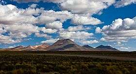 The southwest part of the complex is formed by the cinder cone Cerro Negro and the stratovolcano Cerros de Macón. | |
| Highest point | |
| Elevation | 5,703 m (18,711 ft) [1] |
| Coordinates | 22°57′S 67°45′W / 22.950°S 67.750°WCoordinates: 22°57′S 67°45′W / 22.950°S 67.750°W [2] |
| Geography | |
| Location | Chile |
| Geology | |
| Age of rock | Holocene |
| Mountain type | Pyroclastic shield, volcanic complex |
The Purico complex is a Pleistocene volcanic complex in Chile close to Bolivia, formed by an ignimbrite, several lava domes and stratovolcanoes and one maar. It is one of the Chilean volcanoes of the Andes, and more specifically the Chilean segment of the Central Volcanic Zone, one of the four volcanic belts which make up the Andean Volcanic Belt. The Central Volcanic Zone spans Peru, Bolivia, Chile and Argentina and includes 44 active volcanoes as well as the Altiplano-Puna volcanic complex, a system of large calderas and ignimbrites of which Purico is a member of. Licancabur to the north, La Pacana southeast and Guayaques to the east are separate volcanic systems.
The Purico complex consists of a shield shaped volcanic structure consisting of the Purico ignimbrite and a number of secondary volcanoes that are emplaced on this volcanic shield. During the ice ages, the shield was in part covered by glaciers which have left moraines. Purico is the source of the Purico ignimbrite, a moderately large ignimbrite with a volume of about 80–100 cubic kilometres (19–24 cu mi). After the emplacement of the Purico ignimbrite, a number of lava domes and stratovolcanoes developed on the ignimbrite shield. The maar of Alitar is still fumarolically active. In historical times, sulfur was mined on Purico, and presently the Llano de Chajnantor Observatory lies on the ignimbrite shield.
Geography and structure
The Purico complex lies in Chile close to the border between Bolivia and Chile,[3] east of the town of San Pedro de Atacama[2] and northeast of Toconao.[4] The volcanic complex can be seen from San Pedro de Atacama.[5] A road runs along the northern and eastern margin of the Purico complex,[4] and a gas pipeline crosses the complex as well.[6] The existence of the Purico complex was established on the basis of Landsat images.[7]
Regional
Licancabur volcano was constructed on ignimbrites from Purico[8] just north of the complex.[3] Guayaques lies east of Purico,[9] the La Pacana caldera is located southeast of the complex, and La Pacana's Filo Delgado ignimbrite has buried part of the Purico ignimbrite.[10] The known volcanoes Lascár and El Tatio are found at larger distances from Purico.[11]
Purico is part of the Central Volcanic Zone (CVZ), a belt of volcanoes that runs along the western margin of South America between 14° and 28° southern latitude.[12] This belt is one of four separate volcanic belts that make up the Andean Volcanic Belt and which are separated from each other by gaps where no recent volcanism occurs. The CVZ segment includes 44 active systems, 18 minor volcanic centres and over 6 large ignimbrite or caldera systems. One of these volcanoes, Ojos del Salado, is the highest volcano in the world. The largest historical eruption in the CVZ occurred in 1600 at Huaynaputina in Peru.[13]
Local

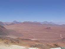
Purico is a circular shield with a diameter of 15–25 kilometres (9.3–15.5 mi), whose slopes descend away from a centre at an elevation of 5,000 metres (16,000 ft).[4] This shield forms a plateau, which is known as the Chajnantor Plateau,[14] and which contains further flat areas such as Llano de Chajnantor, Pampa El Vallecito and Pampa La Bola.[15] There is no evidence that a caldera exists there, unlike in many other volcanoes of this type.[9] To the west, close to the margin of the Salar de Atacama, the shield drops down to a bajada (a structure formed by debris flows and gravel fans).[14] A north-south trending system of fractures and conspicuous normal faults cuts across the western margin of the Purico complex.[16]
On top of this shield, a complex of lava domes and lavas reaches elevations of over 5,800 metres (19,000 ft) above sea level;[2] the vent of the ignimbrite may be buried beneath this complex.[17] This complex forms approximately a 10 by 20 kilometres (6.2 mi × 12.4 mi) wide semicircle open to the southwest around the centre of the shield,[9] which may reflect the existence of a ring fault on which the individual centres were emplaced.[1]
Clockwise starting from the west this semicircle includes 5,016 metres (16,457 ft) high Cerro Negro (23°1′0″S 67°51′0″W / 23.01667°S 67.85000°W), Cerro Purico, "dacite dome D" and 5,639 metres (18,501 ft) high El Cerillo which is also known as Cerro Chajnantor (22°59′0″S 67°44′0″W / 22.98333°S 67.73333°W), 5,703 metres (18,711 ft) high Cerro El Chascon (23°1′0″S 67°41′0″W / 23.01667°S 67.68333°W), the 5,262 metres (17,264 ft) high Cerro Aspero (23°5′0″S 67°42′0″W / 23.08333°S 67.70000°W and the 5,462 metres (17,920 ft) high Cerro Putas (23°6′0″S 67°43′0″W / 23.10000°S 67.71667°W) to the south. All these domes (with the exception of the pancake-like "dacite dome D") have conical shapes, and Aspero, El Cerillo and El Chascon appear to be post-glacial in age.[18][4]
The Chascon dome is constructed by lava flows and has a well preserved summit crater,[1] while Cerro Purico is a stratovolcano and also known as Cerro Toco (22°57′0″S 67°47′0″W / 22.95000°S 67.78333°W).[18] Additional more subdued structures in the principal complex are 5,058 metres (16,594 ft) high Cerro Agua Amarga (23°1′0″S 67°43′0″W / 23.01667°S 67.71667°W) just southwest of El Chascon and the Cordon Honor with Cerro Purico Sur in the "opening" of the semicircle.[9][18] Lahars and debris flows from the volcanoes have covered parts of the ignimbrite shield with gravels.[19] A meltwater-fed spring on Cerro Toco is known as Aguada Pajaritos, and a small lake Laguna de Agua Amarga is found south of Chascon.[20] Presently, the Purico complex forms the drainage divide between the Salar de Atacama and the Salar de Pujsa.[21] The 5,130 metres (16,830 ft) high Macon stratovolcano (23°2′0″S 67°49′0″W / 23.03333°S 67.81667°W) and the Alitar maar (23°9′0″S 67°38′0″W / 23.15000°S 67.63333°W) lie to the south of the main complex.[1][18]

Geology
West of South America, the Nazca Plate subducts beneath the South America Plate[12] at rates of 9–7 centimetres per year (3.5–2.8 in/year). This subduction process along with that of the Antarctic Plate beneath the South American Plate farther south is responsible for volcanism in the Andean Volcanic Belt.[13]
Volcanic activity in the region of the Central Volcanic Zone has been ongoing for 200 million years, but with temporal and local variations; 25 million years ago for example it was centered farther east and later moved west.[22] About 23 million years ago, large scale ignimbritic activity commenced in the region with the emplacement of the Oxaya Formation, followed by the Altos de Pica Formation 17-15 million years ago. However, effusive activity of andesitic composition dominated volcanism until the late Miocene.[23]
Regional
Purico appears to be part of a group of large, caldera-forming volcanic centres that erupted dacitic ignimbrites, a group that is known as the Altiplano-Puna volcanic complex. This group includes the Cerro Guacha, Cerro Panizos, Coranzulí, La Pacana, Pastos Grandes and Vilama centres that cluster around the tripoint between Argentina, Bolivia and Chile.[24] The arid climate of this region means that most volcanic systems are well preserved with little erosion.[23]
This complex is underpinned by a magma body at depths of 15–35 kilometres (9.3–21.7 mi), where arc magmas interact with the crust to form the secondary magmas later erupted by the volcanoes of the Altiplano-Puna volcanic complex.[25] This magma body has been imaged with seismic tomography as a sill-like body and has been named the "Altiplano-Puna magma body".[26]
Ignimbritic activity in such systems is episodic, being interrupted by periods with lower volume "steady state" volcanism.[22] The eruption of the Purico ignimbrite is the youngest large ignimbrite eruption in the Altiplano-Puna volcanic complex;[27] the Altiplano-Puna volcanic complex presently is in such a "steady state" stage,[3] but the presence of active geothermal system indicates that magmatic activity is still ongoing.[27]
Local
Outcrops in the region range in age from Paleozoic to Holocene.[28] The Purico complex formed on top of older ignimbrites such as the Atana ignimbrite in the south and the Puripicar ignimbrite farther north;[17] the neighbouring La Pacana caldera between 4.5 and 4.1 million years ago erupted some of these ignimbrites including the Atana ignimbrite.[4] Occasionally Purico is considered part of the La Pacana system.[29]
Composition
The Purico complex has erupted various different magmas, ranging from the dacitic Purico ignimbrite[30] over rhyolitic pumices contained in the ignimbrite[31] to the andesitic-dacitic post-ignimbrite volcanics.[30] Dacite is the dominant component and forms a crystal-rich potassium-rich suite.[3] Varying amounts of phenocrysts occur in the Purico complex rocks; the minerals they are formed of include augite, biotite, clinopyroxene, hornblende, hypersthene, iron oxides, oligoclase, orthopyroxene, plagioclase, quartz and titanium oxides.[30]
Additionally, mafic xenoliths are found in the Purico ignimbrite; such xenoliths are a common finding in volcanic arc rocks.[32] They are even more common in Chascon rocks, where they might reflect the occurrence of mafic magma in the feeder system prior to the formation of Chascon.[33]
Some physical properties of the Purico magmas have been inferred from the chemistry and petrology of the erupted rocks. The dacites had temperatures of about 750–810 °C (1,380–1,490 °F) while the andesites and rhyolites reached higher temperatures, up to 800–880 °C (1,470–1,620 °F). Water contents ranged from 3.2 to 4.8% by weight, while carbon dioxide concentrations were low throughout.[34]
Climate and vegetation
The climate at Purico is cold (mean temperatures −3 – −4 °C (27–25 °F)[11]), with the air thin because of the high elevation.[35] There is little precipitation in the area (about 200 millimetres per year (7.9 in/year) on the upper parts of the shield, decreasing to less than 10 millimetres per year (0.39 in/year) close to the Salar de Atacama[36]), which mainly happens during the summer months[6] as a consequence of the South American monsoon.[36] This dry climate is due to the combined effects of the subtropical ridge, the Humboldt Current in the Pacific Ocean and the rain shadow exercised by the Andes, but it was in the past interrupted by wet periods.[37]
The dry climate and high elevation mean that vegetation is scarce in the region.[6] The little vegetation that is present displays an altitudinal zonation with a lower "Prepuna" with shrubs and succulents, a middle "Puna" with grasses and shrubs and a "high Andean steppe" with bunch grass. [38] A report in 1993 stated that red-brown cacti and brown grass grew around the foot of Purico.[5]

Increased moisture availability during the ice ages caused the development of glaciers on Purico;[39] at times, an ice cap with outlet glaciers covered over 200 square kilometres (77 sq mi) on Purico.[40] Apparently three different stages of glaciation occurred, the third between 30,000–25,000 years ago, the second between 50,000–60,000 years ago and the first over 100,000 years ago.[39] These glaciations have left moraines on Purico which extend for many kilometres at altitudes of 4,400–4,600 metres (14,400–15,100 ft), sometimes descending as far down as 4,200 metres (13,800 ft). The moraines reach heights of 10 metres (33 ft) on the eastern side of Purico and 2–5 metres (6 ft 7 in–16 ft 5 in) on its western side. These moraines are covered with boulders and accompanied by striated surfaces and erratics.[41] Penitentes still occur on Purico to this day.[42]
Eruptive history
The Purico complex is the source of the major Purico ignimbrite.[7] It was originally called Cajon ignimbrite and attributed to an area northwest of Purico known as Chaxas. Also, the Toconao ignimbrite was originally attributed to the Purico complex,[7] but now the La Pacana caldera is considered to be its source.[43]
The Purico ignimbrite itself covers a surface area of 1,500 square kilometres (580 sq mi) over the whole complex, and its volume has been estimated to be 80–100 cubic kilometres (19–24 cu mi) with an additional 0.4 cubic kilometres (0.096 cu mi) contributed by tephra fall deposits.[31] The ignimbrite is 250 metres (820 ft) thick and becomes thinner westward,[28] with more distal sectors reaching thicknesses of 25 metres (82 ft).[44] Potassium-argon dating has yielded ages between 1,380,000 ± 70,000 and 870,000 ± 520,000 years ago for the Purico ignimbrite.[4] The 2 cubic kilometres (0.48 cu mi) large[44] "dacitic dome D" has an age of 980,000 ± 50,000 and may thus have formed at the same time as the ignimbrites.[4]
The Purico ignimbrite contains three flow units, the two Lower Purico Ignimbrites and the Upper Purico Ignimbrite.[31] Their thicknesses differ; the Upper ignimbrite is 10–12 metres (33–39 ft) thick while the two lower ones together reach an average thickness of 30 metres (98 ft),[45] with a maximum of 80 metres (260 ft).[46] The lowermost Lower Purico Ignimbrite is one single flow. The upper Lower Purico Ignimbrite is more heterogeneous, starting with a base surge, a pumice layer and then another flow unit,[31] which is volumetrically the largest part. The Lower Purico Ignimbrite covers a surface of 800 square kilometres (310 sq mi) primarily on the western side of the Purico complex.[46] Finally, the Upper Purico Ignimbrite is a moderately to densely welded flow that occurs particularly close to the summit of the Purico complex,[31] where it forms six flow units that contain fiamme textures.[47] Characteristic for the Purico ignimbrite is the so-called "banded" pumice, which consist of alternating darker mafic and brighter components, in the upper 33% of the ignimbrite.[48] The extrusion of the Purico ignimbrite was accompanied by the eruption of large amounts of tephra, some of which fell as far as the Coastal Cordillera west of Purico.[49]
After emplacement, the ignimbrites were modified by fluvial erosion, which formed curvilinear channels in the ignimbrites.[50] In contrast to other ignimbrites in the region, there is little evidence of eolian erosion of the Purico ignimbrite. Eolian erosion takes much longer than fluvial erosion and it is possible that the Purico ignimbrite is too young to have been modified by wind action.[51] Some surfaces of the ignimbrite have been affected by glaciation, giving them a smooth surface.[52]
This structure of the ignimbrite has been explained by magma chamber processes. Prior to the Purico ignimbrite eruption, a dacitic magma chamber already existed beneath the volcano. Probably after an injection of andesitic magma, dacitic contents of the magma chamber escaped upwards and formed the lowermost Lower Purico Ignimbrite. This injection of mafic magma rapidly increased the temperature and gas content of the dacite, causing the eruption to become a violent Plinian eruption with the development of an eruption column. This phase then drew onto denser dacitic magma, causing the column to collapse and the Upper Purico Ignimbrite and the "dacite dome D" to form.[53]
Post-ignimbrite activity

Volcanic activity after the eruption of the ignimbrite has been subdivided into the older andesitic Purico group and the younger Chascon group. The first includes Cerro Negro, Cerro Purico, Putas and Cerro Toco which assume the structure of polygenetic volcanoes, while the latter is taken to include Aspero, El Cerillo/Chajnantor and El Chascon which are lava dome-lava flow structures.[54] The Chascon group of domes is also the only one which contains mafic xenoliths.[55]
The Cerro Purico and Macon volcanoes formed a short time after, and possibly even before, the ignimbrites. They are thus old volcanic centres and deeply eroded, displaying moraine deposits from glaciation and rocks which have been subject to hydrothermal alteration from fumarolic activity.[56] Such hydrothermal alteration processes are also the origin of the sulfur deposits at Purico.[35]
Aspero, Cerro El Chascon, Cerros El Negro and Putas are younger and show no evidence of glaciation. El Chascon especially may be only tens of thousands of years old, seeing as it displays both a summit crater and pristine lava flow structures.[56] Aspero was once considered to be of Holocene age;[46] later, dates of 180,000 ± 20,000 years ago were obtained on Aspero and Chascon.[3] Apart from these, there are no radiometric dates for post-ignimbrite volcanic structures at Purico.[14] The eruptive episode that formed these centres is thus more recent than the Purico ignimbrite and may have been triggered by mafic magma being injected into the Purico system. It is also much smaller, with volumes ranging 0.36–4 cubic kilometres (0.086–0.960 cu mi).[31]
This change in the pattern of eruptive activity from large ignimbrites to smaller domes reflects a change in the nature of the magma supply, from large volume flow that heavily interacted with the crust and gave rise to the ignimbrites to smaller volume flows in a colder and thus brittler crust and did not accumulate or interact with it in a significant way.[57] Thus the later eruption products appear to be more primitive and less affected by crustal contamination.[58]
The Macon stratovolcano is considered to be of Holocene age, and Alitar maar displays active fumaroles.[1] Presently, there is no indication of seismic activity in the Purico area.[59]
Other
Purico has been quarried for building materials, and many buildings in San Pedro de Atacama were built from rocks quarried there.[5] As recently as 1993, sulfur was mined on Purico and transported by truck to San Pedro de Atacama where it was processed.[35] In that year, production of sulfur amounted to 200 tonnes per month (2,400 t/a).[60]
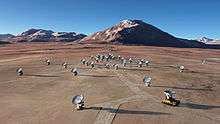
The Purico complex is the site of a number of astronomical observatories,[11] including but not limited to the Llano de Chajnantor Observatory[61] and the Atacama Large Millimeter Array.[52] In 1998, the Cerro Chascón Science Preserve was established on Purico, which among other things disallows mining in the area of the preserve.[62] This Science Preserve covers most of the Purico complex.[61]
See also
References
- 1 2 3 4 5 "Purico Complex". Global Volcanism Program. Smithsonian Institution.
- 1 2 3 Francis et al. 1984, p. 106.
- 1 2 3 4 5 Burns et al. 2015, p. 77.
- 1 2 3 4 5 6 7 Schmitt et al. 2001, p. 682.
- 1 2 3 Oppenheimer 1993, p. 66.
- 1 2 3 Rojas 2009, p. 2.
- 1 2 3 Francis et al. 1984, p. 108.
- ↑ Figueroa, Oscar; Déruelle, Bernard; Demaiffe, Daniel (April 2009). "Genesis of adakite-like lavas of Licancabur volcano (Chile—Bolivia, Central Andes)". Comptes Rendus Geoscience. 341 (4): 311. Bibcode:2009CRGeo.341..310F. doi:10.1016/j.crte.2008.11.008.
- 1 2 3 4 Hawkesworth et al. 1982, p. 241.
- ↑ Lindsay et al. 2001, p. 164.
- 1 2 3 Ward et al. 2015, p. 99.
- 1 2 Silva 1989, p. 1102.
- 1 2 Stern, Charles R. (December 2004). "Active Andean volcanism: its geologic and tectonic setting". Revista geológica de Chile. 31 (2): 161–206. doi:10.4067/S0716-02082004000200001. ISSN 0716-0208.
- 1 2 3 Cesta & Ward 2016, p. 413.
- ↑ Sakamoto, S. (2002). "Comparison of the Pampa La Bola and Llano de Chajnantor sites in northern Chile". 266: 444. Bibcode:2002ASPC..266..440S. ISBN 1-58381-106-0. ISSN 1050-3390.
- ↑ Tibaldi, A.; Bonali, F.L. (February 2018). "Contemporary recent extension and compression in the central Andes". Journal of Structural Geology. 107: 83. Bibcode:2018JSG...107...73T. doi:10.1016/j.jsg.2017.12.004. ISSN 0191-8141.
- 1 2 de Silva 1989, p. 121.
- 1 2 3 4 "Purico Complex". Global Volcanism Program. Smithsonian Institution. , Synonyms & Subfeatures
- ↑ Cesta & Ward 2016, p. 419.
- ↑ Otárola et al. 2002, p. 8.
- ↑ Niemeyer F, Hans F. (1980). "Hoyas hidrográficas de Chile : segunda Región de Antofagasta" (PDF) (in Spanish): 170,192.
- 1 2 Burns et al. 2015, p. 76.
- 1 2 Silva 1989, p. 1103.
- ↑ Schmitt et al. 2001, p. 681.
- ↑ Schmitt et al. 2001, p. 697.
- ↑ Chmielowski, Zandt & Haberland 1999, p. 785.
- 1 2 Chmielowski, Zandt & Haberland 1999, p. 783.
- 1 2 Rojas 2009, p. 3.
- ↑ Silva 1989, p. 1104.
- 1 2 3 Francis et al. 1984, pp. 109–111.
- 1 2 3 4 5 6 Schmitt et al. 2001, p. 683.
- ↑ Francis et al. 1984, pp. 110–111.
- ↑ Francis et al. 1984, pp. 120–121.
- ↑ Schmitt et al. 2001, pp. 690, 692.
- 1 2 3 Oppenheimer 1993, p. 67.
- 1 2 Cesta & Ward 2016, p. 414.
- ↑ Bailey et al. 2007, p. 33.
- ↑ Cesta & Ward 2016, pp. 414–415.
- 1 2 Cesta & Ward 2016, p. 416.
- ↑ Ward et al. 2015, pp. 99, 106.
- ↑ Ward et al. 2015, p. 104.
- ↑ Arnoldo, Ortíz Riveros,; Enrique, Zarate C.,; José, Borcosque,; Luis, Lira,; Jorge, Silva Pais,; Francisco, Ferrando A.,; Francisco, Díaz,; Gerardo, Reyes,; Ángel, Ayerdi Esnaola, (1976). "Inventario de recursos naturales por método de percepción del satélite Landsat, II Región Antofagasta" (in Spanish): 53.
- ↑ Lindsay et al. 2001, p. 159.
- 1 2 Schmitt, Axel K. (2001-12-10). "Gas‐saturated crystallization and degassing in large‐volume, crystal‐rich dacitic magmas from the Altiplano‐Puna, northern Chile". Journal of Geophysical Research: Solid Earth. 106 (B12): 30563. Bibcode:2001JGR...10630561S. doi:10.1029/2000JB000089. ISSN 2156-2202.
- ↑ Bailey et al. 2007, p. 28.
- 1 2 3 de Silva 1989, p. 122.
- ↑ de Silva 1989, p. 123.
- ↑ Francis et al. 1984, p. 110.
- ↑ Breitkreuz, Christoph; de Silva, Shanaka L.; Wilke, Hans G.; Pfänder, Jörg A.; Renno, Axel D. (2014-01-01). "Neogene to Quaternary ash deposits in the Coastal Cordillera in northern Chile: Distal ashes from supereruptions in the Central Andes". Journal of Volcanology and Geothermal Research. 269: 80. Bibcode:2014JVGR..269...68B. doi:10.1016/j.jvolgeores.2013.11.001.
- ↑ Bailey et al. 2007, pp. 35–36.
- ↑ Bailey et al. 2007, p. 39.
- 1 2 Otárola et al. 2002, p. 4.
- ↑ Schmitt et al. 2001, p. 695.
- ↑ Davidson, Jon P.; Silva, Shanaka De; Holden, Peter; Halliday, Alex N. (1990-10-10). "Small‐scale disequilibrium in a magmatic inclusion and its more silicic host". Journal of Geophysical Research: Solid Earth. 95 (B11): 17661–17675. Bibcode:1990JGR....9517661D. doi:10.1029/JB095iB11p17661. ISSN 2156-2202.
- ↑ Hawkesworth et al. 1982, p. 242.
- 1 2 Francis et al. 1984, p. 109.
- ↑ Burns et al. 2015, p. 84.
- ↑ Burns et al. 2015, p. 85.
- ↑ Otárola et al. 2002, p. 1.
- ↑ Oppenheimer 1993, p. 68.
- 1 2 "Topographical Map of CONICYT Science Preserve" (PDF). National Radio Astronomy Observatory. Retrieved 2012-01-26.
- ↑ Cohen, R. J. (2003). Organizations and Strategies in Astronomy. Astrophysics and Space Science Library. Springer Netherlands. p. 68. doi:10.1007/978-94-010-0049-9_5. ISBN 9789401039895.
Sources
- Bailey, John E.; Self, Stephen; Wooller, Luke K.; Mouginis-Mark, Peter J. (2007-05-15). "Discrimination of fluvial and eolian features on large ignimbrite sheets around La Pacana Caldera, Chile, using Landsat and SRTM-derived DEM". Remote Sensing of Environment. 108 (1): 24–41. Bibcode:2007RSEnv.108...24B. doi:10.1016/j.rse.2006.10.018.
- Burns, Dale H.; de Silva, Shanaka L.; Tepley III, Frank; Schmitt, Axel K.; Loewen, Matthew W. (2015-07-15). "Recording the transition from flare-up to steady-state arc magmatism at the Purico–Chascon volcanic complex, northern Chile". Earth and Planetary Science Letters. 422: 75–86. Bibcode:2015E&PSL.422...75B. doi:10.1016/j.epsl.2015.04.002.
- Cesta, Jason M.; Ward, Dylan J. (2016-11-15). "Timing and nature of alluvial fan development along the Chajnantor Plateau, northern Chile". Geomorphology. 273: 412–427. Bibcode:2016Geomo.273..412C. doi:10.1016/j.geomorph.2016.09.003.
- Chmielowski, Josef; Zandt, George; Haberland, Christian (1999-03-15). "The Central Andean Altiplano‐Puna magma body". Geophysical Research Letters. 26 (6): 783–786. Bibcode:1999GeoRL..26..783C. doi:10.1029/1999GL900078. ISSN 1944-8007.
- de Silva, S. L. (1989-05-01). "Geochronology and stratigraphy of the ignimbrites from the 21°30′S to 23°30′S portion of the Central Andes of northern Chile". Journal of Volcanology and Geothermal Research. 37 (2): 93–131. Bibcode:1989JVGR...37...93D. doi:10.1016/0377-0273(89)90065-6.
- Francis, P. W.; McDonough, W. F.; Hammill, M.; O'Callaghan, L. J.; Thorpe, R. S. (1984). Harmon, R. S.; Barreiro, B. A., eds. Andean Magmatism. Birkhäuser Boston. pp. 106–123. doi:10.1007/978-1-4684-7335-3_8. ISBN 9781468473377.
- Hawkesworth, C. J.; Hammill, M.; Gledhill, A. R.; van Calsteren, P.; Rogers, G. (1982-04-01). "Isotope and trace element evidence for late-stage intra-crustal melting in the High Andes". Earth and Planetary Science Letters. 58 (2): 240–254. Bibcode:1982E&PSL..58..240H. doi:10.1016/0012-821x(82)90197-2.
- Lindsay, J. M; de Silva, S; Trumbull, R; Emmermann, R; Wemmer, K (2001-04-01). "La Pacana caldera, N. Chile: a re-evaluation of the stratigraphy and volcanology of one of the world's largest resurgent calderas". Journal of Volcanology and Geothermal Research. 106 (1–2): 145–173. Bibcode:2001JVGR..106..145L. doi:10.1016/S0377-0273(00)00270-5.
- Oppenheimer, Clive (1993-03-01). "Mines in the sky". Geology Today. 9 (2): 66–68. doi:10.1111/j.1365-2451.1993.tb00983.x. ISSN 1365-2451.
- Otárola, Angel; Hofstadt, Daniel; Radford, Simon J.E.; Sakamoto, Seiichi (18 March 2002). "ALMA MEMO # 413 PHYSICAL PARAMETERS OF THE CHAJNANTOR SCIENCE PRESERVE" (PDF). library.nrao.edu. National Radio Astronomy Observatory.
- Rojas, Luis (March 2009). "ALMA Memo # 408: REPORT GEO 99/37 (REV. A): GEOTECHNICAL STUDY CHAJNANTOR SITE, II REGION NOBEYAMA RADIO OBSERVATORY" (PDF). library.nrao.edu. National Radio Astronomy Observatory.
- Schmitt, A.; Silva, S. de; Trumbull, R.; Emmermann, R. (2001-03-01). "Magma evolution in the Purico ignimbrite complex, northern Chile: evidence for zoning of a dacitic magma by injection of rhyolitic melts following mafic recharge". Contributions to Mineralogy and Petrology. 140 (6): 680–700. Bibcode:2001CoMP..140..680S. doi:10.1007/s004100000214. ISSN 0010-7999.
- Silva, S. L. de (1989-12-01). "Altiplano-Puna volcanic complex of the central Andes". Geology. 17 (12): 1102–1106. doi:10.1130/0091-7613(1989)017<1102:APVCOT>2.3.CO;2. ISSN 0091-7613.
- Ward, Dylan J.; Cesta, Jason M.; Galewsky, Joseph; Sagredo, Esteban (2015-11-15). "Late Pleistocene glaciations of the arid subtropical Andes and new results from the Chajnantor Plateau, northern Chile". Quaternary Science Reviews. 128: 98–116. Bibcode:2015QSRv..128...98W. doi:10.1016/j.quascirev.2015.09.022.
Further reading
- Crustal architecture and magma dynamics in a large continental magmatic system: a case study of the Purico-Chascon Volcanic Complex, Northern Chile
- González-Ferrán, Oscar (1995). Volcanes de Chile (in Spanish). Santiago: Instituto Geográfico Militar. ISBN 956-202-054-1.
External links
