Maipo (volcano)
| Maipo | |
|---|---|
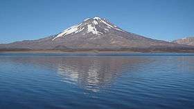 Maipo volcano in 2008 | |
| Highest point | |
| Elevation | 5,264 m (17,270 ft) [note 1] |
| Coordinates | 34°09′39.6″S 69°49′58.8″W / 34.161000°S 69.833000°WCoordinates: 34°09′39.6″S 69°49′58.8″W / 34.161000°S 69.833000°W |
| Geography | |
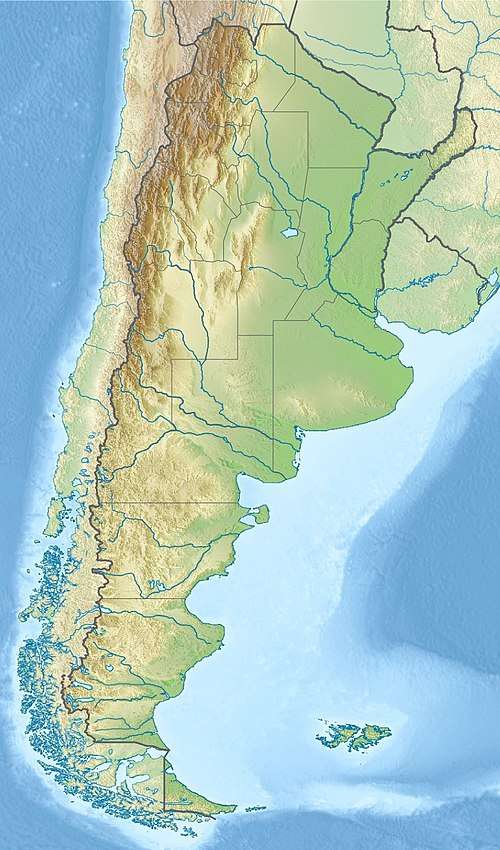 Maipo Location on Argentina – Chile border | |
| Location | Argentina – Chile |
| Parent range | Andes |
| Geology | |
| Mountain type | Stratovolcano |
| Last eruption | 1912[1] |
| Climbing | |
| First ascent | 1883 by Paul Güssfeldt[2] |
| Easiest route | snow/ice climb |
Maipo is a stratovolcano in the Andes, lying on the border between Argentina and Chile. It is located 90 km (56 mi) south of Tupungato and about 100 km (62 mi) southeast of Santiago.
Maipo retains a symmetrical, conical volcanic shape, and is among the southernmost 5,000 metre peaks in the Andes.[3]
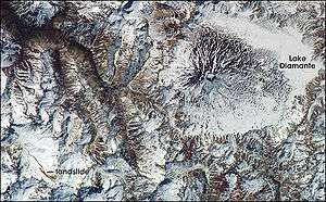
Maipo is located within the Diamante caldera, a feature of about 15 km by 20 km size that is about one-half million years old. It rises about 1,900 m (6,230 ft) above the floor of the caldera. Immediately to the east of the peak, on the eastern side of the caldera floor, is Laguna del Diamante, a picturesque lake that formed when lava flows blocked drainage channels from the caldera in 1826. The Diamante Caldera erupted 450 cubic kilometers (108 cu mi) of tephra, 450 ka.[4]
The region's climate is transitional between the drier Mediterranean climate of the peaks to the north and the cold, moist climate of Chilean Patagonia. Hence, while less glaciated than Patagonia, it has more permanent snow (on the wet, Chilean side) than peaks of similar elevation to the north.[3]
See also
References
- ↑ "Maipo". Global Volcanism Program. Smithsonian Institution. Retrieved 2015-01-10.
- ↑ Neate, Jill (1994). "Central Chile". Mountaineering in the Andes (2nd ed.). Expedition Advisory Centre. ISBN 0-907649-64-5.
- 1 2 Kelsey, Michael R. (1990). Climbers and Hikers Guide to the World's Mountains (3rd ed.). Kelsey Publishing. ISBN 0-944510-02-7.
- ↑ "Supplementary Table to P.L. Ward, Thin Solid Films (2009) Major volcanic eruptions and provinces" (PDF). Teton Tectonics. Archived from the original (PDF) on 2010-01-20. Retrieved 2010-03-16.
- Notes
- Sources
- Volcan Maipo or Maipú (span.)
- "Maipo". Global Volcanism Program. Smithsonian Institution.
- Sruoga, P.; Llambías, E.J.; Fauqué, L.; Schonwandt, D.; Repol, D.G. (2005). "Volcanological and geochemical evolution of the Diamante Caldera-Maipo volcano complex in the Southern Andes of Argentina (34°10'S)". J. South American Earth Sci. 19: 399–414.
| Wikimedia Commons has media related to Maipo. |