Incahuasi
| Incahuasi | |
|---|---|
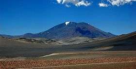 Incahuasi volcano as seen from route 60, Fiambala, Argentina | |
| Highest point | |
| Elevation | 6,621 or 6,638 m (21,722 or 21,778 ft) [1][2] |
| Prominence | 1,518 m (4,980 ft) [1] |
| Listing | Ultra |
| Coordinates | 27°01′59″S 68°17′46″W / 27.033°S 68.296°WCoordinates: 27°01′59″S 68°17′46″W / 27.033°S 68.296°W [2] |
| Geography | |
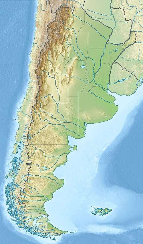 Incahuasi Location in Argentina, on the border with Chile | |
| Location |
Catamarca, Argentina - Atacama, Chile |
| Parent range | Andes |
| Geology | |
| Mountain type | stratovolcanoes and caldera |
| Last eruption | Unknown |
| Climbing | |
| First ascent | 1913 by Walther Penck |
Incahuasi (Spanish pronunciation: [iŋkaˈwasi]; possibly from Quechua: inka Inca, wasi house)[3][4] is a volcanic mountain in the Andes of South America. It lies on the border of the Argentine province of Catamarca, and the Atacama Region of Chile. Incahuasi has a summit elevation of 6,621 metres (21,722 ft) above sea level.
The volcano consists of a 3.5-kilometre-wide (2.2 mi) caldera and two stratovolcanoes. Four pyroclastic cones are located 7 kilometres (4.3 mi) to the north-east and produced basalt-andesite lava flows that cover an area of 10 square kilometres (4 sq mi).[5]
Geography and geology
Incahuasi lies on the border between Argentina and Chile,[2] close to Paso San Francisco.[6] A major road crosses the border there.[7]
Regional
Incahuasi is part of the Central Volcanic Zone of the Andes together with about 110 other Quaternary volcanoes, and lies in the southern sector of the volcanic zone;[8] other volcanic zones in the Andes are the Northern Volcanic Zone, the Southern Volcanic Zone and the Austral Volcanic Zone.[9] The history of volcanic activity is poorly known for most of these volcanoes owing to the lack of dating; only a few historical eruptions have been recorded, such as an eruption at Ojos del Salado in 1993.[8]
Incahuasi is located northeast of Ojos del Salado,[2] the highest volcano in the world.[10] Both volcanoes are found at the southern end of the Central Volcanic Zone.[11] They together with El Fraile, Cerro El Muerto, Nevado Tres Cruces and El Solo form a 50 kilometres (31 mi) long volcanic chain.[12]
The area is dominated by volcanoes that were active after 1.5 million years ago.[13] Also located close to Incahuasi are Falso Azufre and Nevado San Francisco,[6] as well as the Miocene Cerro Morocho and Cerro Ojo de Las Lozas volcanoes.[14] It has been suggested that a perpendicular chain of volcanoes including Ojos del Salado may be the consequence of the Juan Fernandez Ridge subducting in the Peru-Chile Trench.[15]
Volcanism in the area goes back to the Oligocene and Miocene, when the main volcanic arc was located 40 kilometres (25 mi) west in the Maricunga Belt. Between 9 and 6 million years ago volcanic activity in the Maricunga Belt decreased and eventually ceased. Simultaneously, the back-arc experienced increased volcanic activity.[11]
Local
Incahuasi is formed by a caldera 3.5 kilometres (2.2 mi) wide. Two coalesced stratovolcanoes formed within the caldera[2] and have a diameter of 15 kilometres (9.3 mi).[16] A 6 by 4 kilometres (3.7 mi × 2.5 mi) wide lava dome is located on the eastern flank.[16] The volcano has a volume of about 231 cubic kilometres (55 cu mi)[17] and covers a surface area of about 207 square kilometres (80 sq mi).[18] With a height of 6,621 metres (21,722 ft) Incahuasi is the 12th highest mountain in South America[19] and one of the world's highest volcanoes.[18]
Incahuasi has two craters, a summit crater and an arcuate crater on the eastern slope that contains a lava dome.[2] The summit crater has dimensions of 750 by 900 metres (2,460 ft × 2,950 ft)[16] and is embedded within a 2 kilometres (1.2 mi) high summit plateau.[14] Subsidiary vents conversely are associated with fissure vents.[20]
The western and southwestern slopes of Incahuasi are dotted with lava domes,[2] which are more subdued than on other volcanoes in the region.[21] Less than 1 kilometre (0.62 mi) wide and 5 kilometres (3.1 mi) long[16] lava flows extend down the volcano.[2] They reach the Las Coladas salar east of Incahuasi.[22] Two 2 kilometres (1.2 mi) long coulees extend north and east of the main crater.[16]
7 kilometres (4.3 mi) northeast of Incahuasi four pyroclastic cones can be found. They have covered 10 square kilometres (3.9 sq mi) with lava[2] but they are probably an independent volcanic system, similar to other regional mafic volcanoes.[23] On Incahuasi's eastern flank lies a major lava dome and a field of lava flows.[14] Incahuasi volcano rises over a surface with elevations of 4,300–4,700 metres (14,100–15,400 ft).[24]
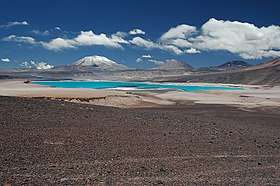 Incahuasi is the volcano at the left and El Fraile immediately right. The green lake is Laguna Verde
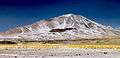 Incahuasi from Las Grutas. The eastern lava domes and the northeastern monogenetic volcanoes are clearly visible.
Composition
Like many Andean volcanoes, Incahuasi has erupted andesite containing hornblende and pyroxene,[6] but also trachyandesite and trachydacite.[25] Lava flows on the main stratovolcano are dacitic.[2]
The four cones northeast of the principal volcano have erupted basaltic andesite.[2] Likewise, parasitic cones have erupted magnesium-rich basaltic andesite.[26] Minerals contained in these rocks include clinopyroxene and olivine.[6]
The occurrence of such basic magmas in a volcanic setting dominated by dacites appears to be a consequence of local tectonics, which involve the extension of the crust compared to the compressional regime farther west.[13] Originating in the mantle, the magmas quickly ascended in faults and were contaminated by crustal material.[6] The mantle itself had been modified before by crustal material added by delamination of the lower crust and subduction erosion.[27]
Climate
Incahuasi does not have glaciers,[24] but it does have at least temporary snowpack.[2] Even the crater does not support the development of glaciers.[28]
Average precipitation at Incahuasi is about 300–500 millimetres per year (12–20 in/year). The volcano lies south of the so-called "Arid Diagonal", and most precipitation falls during winter.[24] This aridity is caused by the rain shadow effect of the Subandean Ranges, which block moisture from the Atlantic Ocean.[29]
Eruptive history
One andesitic lava flow on the northwestern slope of Incahuasi has yielded two ages, one of 1.15 ± 0.5 million years ago and another of 710,000 ± 80,000 years ago.[30] Based on their preservations, the lava flows appear to be of roughly comparable ages.[16] Additional ages were obtained on the main edifice, 1.57 ± 0.1 million years ago, 1.14 ± 0.37 million years ago and 1.00 ± 0.13 million years ago.[31]
Parasitic cones were active over 500,000 years ago.[26] These include the lava dome and lava flow fields (760,000 ± 90,000 and 740,000 ± 50,000 years ago respectively) and a lava flow from the pyroclastic cones, which has been dated to 350,000 ± 30,000 years ago.[31]
Volcanic activity at Incahuasi may have continued into the Holocene, considering the young appearance of its eruption products[2] such as lava flows in the summit region and on the southern slopes; the old ages obtained by radiometric dating indicate an extinct volcano although activity at Andean volcanoes is known to occur with long rest phases between eruptions (reaching one million years).[23] There are reports of fumarolic activity. The volcano is considered a potential geological hazard to Argentina[32] and Chile, where the SERNAGEOMIN hazard maps identify it as a potential threat.[33] The remoteness of the volcano means that future eruptions are unlikely to impact populated areas, however.[34]
 View from Las Grutas
Climbing history
The mountain was first climbed by Inca people. In 1912 Walter Penck climbed the mountain. Legend has it that a railway engineer named Edward Flint between 1854-1859 ascended the mountain.[35]
Archeology
In 1913, an Inca ceremonial structure was found on the summit of Incahuasi.[19]
See also
References
- 1 2 "Argentina and Chile North: Ultra-Prominences" Peaklist.org. Retrieved 2013-02-25.
- 1 2 3 4 5 6 7 8 9 10 11 12 13 "Nevado de Incahuasi". Global Volcanism Program. Smithsonian Institution.
- ↑ Diccionario Quechua - Español - Quechua, Academía Mayor de la Lengua Quechua, Gobierno Regional Cusco, Cusco 2005 (Quechua-Spanish dictionary)
- ↑ Teofilo Laime Ajacopa, Diccionario Bilingüe Iskay simipi yuyayk'ancha, La Paz, 2007 (Quechua-Spanish dictionary)
- ↑ http://www.volcanolive.com/incahuasi.html
- 1 2 3 4 5 Kay, Coira & Mpodozis 2008, p. 163.
- ↑ Gspurning, Lazar & Sulzer 2006, p. 60.
- 1 2 Grosse et al. 2018, p. 2.
- ↑ Grosse et al. 2018, p. 3.
- ↑ Gonzalez-Ferran, Baker & Rex 1985, p. 434.
- 1 2 Kay, Coira & Mpodozis 2008, p. 160.
- ↑ Kay, Mpodozis & Gardeweg 2014, p. 310.
- 1 2 Kay, Coira & Mpodozis 2008, p. 162.
- 1 2 3 Grosse et al. 2018, p. 11.
- ↑ Gonzalez-Ferran, Baker & Rex 1985, p. 425.
- 1 2 3 4 5 6 Grosse, P.; Orihashi, Y.; Guzman, S.; Petrinovic, I. (2014). "Volcanismo Cuaternario en la Zona del Paso San Francisco, Catamarca". conicet.gov.ar (in Spanish).
- ↑ Aravena, Diego; Villalón, Ignacio; Sánchez, Pablo (April 2015). "Igneous Related Geothermal Resources in the Chilean Andes" (PDF). pangea.stanford.edu. p. 5.
- 1 2 Grosse et al. 2018, p. 10.
- 1 2 Rundel & Kleier 2014, p. 3.
- ↑ Seggiaro, R. E.; Hongn, F. D. (1999-01-01). "Influencia tectónica en el volcanismo Cenozoico del Noroeste argentino". Acta geológica hispánica. 34 (2): 229. ISSN 2173-6537.
- ↑ Gonzalez-Ferran, Baker & Rex 1985, p. 436.
- 1 2 Grosse et al. 2018, p. 18.
- 1 2 3 Gspurning, Lazar & Sulzer 2006, p. 61.
- ↑ Grosse et al. 2018, p. 7.
- 1 2 Mpodozis, Constantino; Cornejo, Paula; Kay, Suzanne M.; Tittler, Andrew (1995-12-01). "La Franja de Maricunga: sintesis de la evolucion del Frente Volcanico Oligoceno-Mioceno de la zona sur de los Andes Centrales". Andean Geology (in Spanish). 22 (2): 308. ISSN 0718-7106.
- ↑ Kay, Mpodozis & Gardeweg 2014, p. 324.
- ↑ Gspurning, Lazar & Sulzer 2006, p. 63.
- ↑ Gonzalez-Ferran, Baker & Rex 1985, p. 435.
- 1 2 Grosse et al. 2018, p. 12.
- ↑ Perucca, Laura P.; Moreiras, Stella M. (2009-01-01). Latrubesse, Edgardo M., ed. Developments in Earth Surface Processes. Natural Hazards and Human-Exacerbated Disasters in Latin America. 13. Elsevier. p. 292.
- ↑ "Peligros Volcanicos" (PDF). sernageomin.cl. 2011. ISSN 0717-7305.
- ↑ Grosse et al. 2018, p. 19.
- ↑ Echevarria, Evelio (1987). "Early British Ascents in the Andes (1831-1946)" (PDF). Alpine Journal: 64–65.
Sources
- Gonzalez-Ferran, O.; Baker, P.E.; Rex, D.C. (March 1985). "Tectonic-volcanic discontinuity at latitude 27° south Andean Range, associated with Nazca Plate Subduction". Tectonophysics. 112 (1–4): 423–441. doi:10.1016/0040-1951(85)90189-1.
- Grosse, Pablo; Orihashi, Yuji; Guzmán, Silvina R.; Sumino, Hirochika; Nagao, Keisuke (1 May 2018). "Eruptive history of Incahuasi, Falso Azufre and El Cóndor Quaternary composite volcanoes, southern Central Andes". Bulletin of Volcanology. 80 (5): 44. doi:10.1007/s00445-018-1221-5. ISSN 0258-8900.
- Gspurning, Josef; Lazar, Reinhold; Sulzer, Wolfgang (2006). "Regional Climate and Snow/Glacier Distribution in Southern Upper Atacama (Ojos del Salado) - an integrated statistical, GIS and RS based approach" (PDF). Grazer Schriften der Geographie und Raumforschung. 41: 59–70.
- Kay, Suzanne Mahlburg; Coira, Beatriz; Mpodozis, Constantino (2008-01-01). "Field trip guide: Neogene evolution of the central Andean Puna plateau and southern Central Volcanic Zone". Field Guides. 13: 117–181. doi:10.1130/2008.0013(05). ISBN 978-0-8137-0013-7. ISSN 2333-0937 – via ResearchGate.
- Kay, Suzanne Mahlburg; Mpodozis, Constantino; Gardeweg, Moyra (2014-01-01). "Magma sources and tectonic setting of Central Andean andesites (25.5–28°S) related to crustal thickening, forearc subduction erosion and delamination". Geological Society, London, Special Publications. 385 (1): 303–334. doi:10.1144/SP385.11. ISSN 0305-8719.
- Rundel, Philip W.; Kleier, Catherine C. (2014). "Parque Nacional Nevado de Tres Cruces, Chile: A Significant Coldspot of Biodiversity in a High Andean Ecosystem" (PDF). fs.fed.us.
- Valero-Garcés, Blas; Delgado-Huertas, Antonio; Ratto, Norma; Navas, Ana; Edwards, Larry (2000-09-01). "Paleohydrology of Andean saline lakes from sedimentological and isotopic records, Northwestern Argentina". Journal of Paleolimnology. 24 (3): 343–359. doi:10.1023/A:1008146122074. ISSN 0921-2728.
External links
- "Incahuasi". SummitPost.org.
- Incahuasi (in Spanish)
- "Cerro de Incahuasi, Argentina/Chile" on Peakbagger