El Tatio
El Tatio is a geyser field located in the Andes Mountains of northern Chile at 4,320 metres (14,170 ft) above mean sea level. Various etymologies have been proposed for the name "El Tatio", which might mean "oven" or "grandfather". It is the third-largest geyser field in the world and the largest in the Southern Hemisphere.
El Tatio lies at the western foot of a series of stratovolcanoes, which run along the border between Chile and Bolivia. This series of volcanoes is part of the Central Volcanic Zone, one of several volcanic belts in the Andes, and there are no recorded historical eruptions at the Tatio volcanoes. El Tatio is also part of the Altiplano–Puna volcanic complex (APVC), a system of large calderas and associated ignimbrites, which have been the sources of supereruptions. Some of these calderas may be the source of heat for the El Tatio geothermal system.
El Tatio is a geothermal field with many geysers, hot springs, and associated sinter deposits. These hot springs eventually form the Rio Salado, a major tributary of the Rio Loa, and a major source of arsenic pollution in the river. The vents are sites of populations of extremophile microorganisms and have been studied as analogs for the early Earth and possible past life on Mars.
The field is a major tourism destination in northern Chile. It was prospected over the last century for the potential of geothermal power production, but development efforts were discontinued after a major incident in 2009 in which drilling well blew out, creating a steam column.
Name and research history
The term "tatio" is Kunza and means "to appear", "oven",[1] but it has also been translated as "grandfather"[2] or "burnt". The geyser field is also known as the Copacoya geysers.[3]
The earliest mentions of geysers in the region are from the late 19th century,[4] and they were already well known by 1952.[5] The first geothermal prospecting of the field occurred in the 1920s[6] and the field was mentioned in academic literature in 1943,[7] but more systematic research took place in 1967-1982;[8] most research on this geothermal field was done in the context of geothermal prospecting.[9]
Geomorphology and geography
El Tatio lies in the Antofagasta Province of northern Chile close to the border between Chile and Bolivia.[10][lower-alpha 1] The field is located 80 kilometres (50 mi) north of the town San Pedro de Atacama and 100 kilometres (62 mi) east of the town of Calama.[12] Towns close to El Tatio are Toconce to the north, Caspana to the west, Machuca to the south[13] and a workers' camp for a sulfur mine at Volcan Tatio, which was reported to exist in 1959.[14] The old Inca trail from San Pedro de Atacama to Siloli crossed the geyser field;[3] the Inca also operated a mountain sanctuary on Volcan Tatio.[15] There are several unpaved roads and all parts of the field are easily accessible.[16]
El Tatio is part of the Central Volcanic Zone, a segment of the Andes between 14° and 28° southern latitude where the Andes are volcanically active. This volcanism manifests itself with about 10 silicic caldera complexes of the Altiplano–Puna volcanic complex and more than 50 recently active volcanoes; Lascar in 1993 erupted and produced a tall eruption column.[17]
Andesitic stratovolcanoes reaching elevations of about 5,000 metres (16,000 ft) are found at El Tatio east of the field,[17] while the Sierra de Tucle lies to the southwest of it.[18] From north to south the andesitic stratovolcanoes include the 5,651-metre (18,540 ft) high Cerro Deslinde, the 5,560-metre (18,240 ft) high Cerro El Volcan, the 5,280–5,570-metre (17,320–18,270 ft) high Cordillera del Tatio and the 5,314-metre (17,434 ft) high Volcan Tatio, and they collectively form the El Tatio volcanic group.[19][7][20]
The geothermal field of El Tatio lies in a graben between the stratovolcanoes in the east and the Serrania de Tucle-Loma Lucero horst in the west.[17][20] Mountains southwest of El Tatio include the 4,570–4,690-metre (14,990–15,390 ft) Alto Ojo del Cablor, while 4,812-metre (15,787 ft) high Cerro Copacoya is situated northwest of the geothermal field.[21] Dacitic volcanism, older than the easterly stratovolcanoes, has occurred west of El Tatio;[7] this volcanism was known as the "liparitic formation" and it covers large areas in the region.[lower-alpha 2][23]
Firn and snow fields were reported in the middle 20th century on the El Tatio volcanic group, at elevations of 4,900–5,200 metres (16,100–17,100 ft).[24] The region is too dry to support glaciers today,[25] but in the past higher moisture allowed their formation on mountains of this part of the Andes;[26][27] glacially eroded mountains and moraines testify to their existence.[28] A large moraine complex, including both terminal structures and well-developed lateral moraines, can be found north of the geyser field.[29] Two more moraine systems extend westward both northeast and southeast of El Tatio, and the terrain surrounding the geyser field is covered by sands that are interpreted as glacial outwash sands.[30]
Drainage in the area is generally from east to west down the Western Cordillera,[31] often in form of steeply incised valleys.[14] The Rio Salado drains most of the hot spring water[31][32] and has its headwaters in the field[9] where it is joined by the Rio Tucle.[31][32] Temperature measurements of the water flowing to the Rio Salado have yielded values of 17–32 °C (63–90 °F),[24] while the discharge of the Rio Salado amounts to 0.25–0.5 cubic metres per second (8.8–17.7 cu ft/s).[33] The Rio Salado eventually joins the Rio Loa, a major source of freshwater for the region;[9] thus, El Tatio plays an important role in the regional water supply.[34]
Geothermal field
El Tatio is well known as a geothermal field in Chile,[10] and is the largest geyser field in the southern hemisphere with about 8% of all geysers in the world and is (together with Sol de Mañana) the highest geyser field in the world.[35][12] Only Yellowstone in the United States and Dolina Geizerov in Russia are larger[35] and their geysers are taller than these at El Tatio.[36]

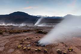
The geothermal field covers an area of 30 square kilometres (12 sq mi) at elevations of 4,200–4,600 metres (13,800–15,100 ft), and is characterized by fumaroles, hot springs, steam vents known as soffioni and steaming soil. Stronger geothermal activity is located within three discrete areas covering a total of 10 square kilometres (3.9 sq mi) surface, and includes boiling water fountains, hot springs, geysers, mudpots, mud volcanoes and sinter terraces;[37][12] further, chimneys of extinct geysers have been noted.[38] One of these three areas lies within a valley, the second on a flat surface and the third along the banks of the Rio Salado.[4] The first area offers a notable contrast between the snow-covered Andes, the coloured hills that surround the field and the white deposits left by the geothermal activity. Most geysers of El Tatio are found here and are particularly noticeable in cold weather. A similar landscape exists at the third (lower) area, with the presence of the Rio Salado river adding an additional element to the landscape.[39][40] The second area is located between a creek and a hill and includes an artificial 15-by-30-metre (49 ft × 98 ft) pool for tourists.[41]
The field once numbered 67 geysers and more than three hundred hot springs. Many vents are linked to fractures that run northwest-southeast or southwest-northeast across the field.[20] Some geyser fountains reached heights greater than 10 metres (33 ft);[42] usually, however, they do not exceed 1 metre (3 ft 3 in).[35] A few geysers have received names, such as Boiling Geyser, El Cobreloa, El Cobresal, El Jefe, Terrace Geyser, Tower Geyser and Vega Rinconada.[43][44][45] An additional geothermal system lies southeast of and at elevations above El Tatio and is characterized by steam-heated ponds fed by precipitation water,[9] and solfataric activity has been reported on the stratovolcanoes farther east.[23]

Deposition of sinter from the waters of the geothermal field has given rise to spectacular landforms, including, but not limited to mounds, terraced pools, geyser cones and the dams that form their rims.[20][37] Small scale features include cones, crusts, mollusc-shaped formations and waterfall-like surfaces.[46] High contents of silica give the waters a blueish colour, organic compounds such as carotenoids conversely often colour the sinter with orange-brown,[47] and greenish hues are owing to iron-oxidizing bacteria.[48]
- Hot springs form pools with water temperatures of 60–80 °C (140–176 °F), which are often gently moving and surging and in the case of the warmer springs actively bubbling. These pools often contain ball-like rocks called oncoids and are surrounded by sinter rims, which have spicule-like textures.[49] These sinter rims often form dam-like structures around deeper vents which are filled with water.[50] Spherical grains develop in the hot springs as a consequence of hydrodynamic processes, and include biogenic material; during the growth of the sinter they often end up embedded in the material.[51]
- Flowing water that drains from the springs deposits sinter, which can form fairly thick deposits and large aprons when sheet flow occurs, known as "discharge deposits"; sometimes terraces are developed instead. As in springs, oncoids and spicules are observed in channels. Much of the water evaporates and its temperature drops from 30–35 °C (86–95 °F) to less than 20 °C (68 °F) away from the springs;[52] the low air temperatures cause it to freeze occasionally, resulting in frost weathering.[53]
- Geysers and also water fountains discharge from up to 3-metre (9.8 ft) high cones[54][50] with gently sloping surfaces, which sometimes support splash mounds[55] and are constructed by geyserite.[56] Other geysers and fountains instead discharge from within rim-bounded pools,[54] and some geysers are located on the bed of the Rio Salado river.[4] The activity of geysers is not stable over time, changes in water supply or in the properties of the conduit that supplies them can cause changes in their eruptive activity. Such changes can be triggered by rainfall events or earthquakes and at El Tatio geyser behaviour changes have been linked to the 2014 Iquique earthquake and a 2013 precipitation event.[57] The water of geysers is 80–85 °C (176–185 °F) warm.[55]
- Mud pools are often bubbling, with the hot mud fountaining.[24] Simmering pools of water have been recorded at El Tatio as well.[3]
 A vent surrounded by yellow rocks
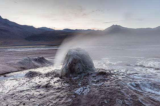 Geyser cone
 Geyser cone
 Geyser cone
Geology
Subduction of the Nazca Plate beneath the South American Plate is responsible for the formation of the Andes. Volcanism does not occur along the entire length of the Andes; there are three volcanic zones called the Northern Volcanic Zone, the Central Volcanic Zone and the Southern Volcanic Zone, all separated by areas with no recent volcanism.[17][58]
El Tatio and a number of other geothermal fields such as Sol de Mañana are part of the Altiplano–Puna volcanic complex. The region was dominated by andesitic volcanism producing lava flows until the late Miocene, then large scale ignimbrite activity took place between 10 and 1 million years ago. This ignimbrite volcanism is part of the APVC proper and produced about 10,000 cubic kilometres (2,400 cu mi) of ignimbrites, covering a surface area of 50,000 square kilometres (19,000 sq mi). The APVC activity continued into the Holocene with the emission of voluminous lava domes and lava flows;[16][17] the present-day uplift of the Uturunku volcano in Bolivia may signal ongoing activity of the APVC.[59]
The Laguna Colorada caldera lies east of El Tatio.[17] The terrain at El Tatio is formed by Jurassic–Cretaceous sediments of marine and volcanic origin, Tertiary–Holocene volcanic formations that were emplaced in various episodes, and recent sediments formed by glaciers, alluvium, colluvium and material formed by the geothermal field, such as sinter.[60][20] Volcanic formations fill the Tatio graben, including the Miocene Rio Salado ignimbrite and related volcanics which reach thicknesses of 1,900 metres (6,200 ft) in some places, the Sifon ignimbrite, the Pliocene Puripicar ignimbrite and the Pleistocene Tatio ignimbrite;[61][62] the Puripicar ignimbrite crops out farther west.[63] Active volcanoes in the area include Putana and Tocorpuri.[64]
Hydrothermal alteration of country rock has occurred at El Tatio, it has yielded large deposits of alteration minerals such as illite, nobleite, smectite, teruggite and ulexite.[61] Likewise, the summit parts of several volcanoes of the El Tatio volcanic group have been bleached and discoloured by hydrothermal activity.[65]
Hydrology
Most of the water that is discharged by the hot springs appears to be precipitation, which enters the ground east and southeast of El Tatio. The source of heat of the whole complex appears to be the Laguna Colorada caldera,[66][20][67] the El Tatio volcanic group[33][37] or the Cerro Guacha and Pastos Grandes calderas.[68][13] The movement of the water in the ground is controlled by the permeability of the volcanic material and the Serrania de Tucle–Loma Lucero tectonic block west of El Tatio that acts as an obstacle.[20][67] As it moves through the ground, it acquires heat and minerals[18] and loses steam through evaporation. Unlike geothermal fields in wetter parts of the world, given the dry climate of the area, local precipitation has little influence on the hot springs hydrology at El Tatio.[69] The time the water takes to traverse the whole path from precipitation to the springs is about 15 years.[10]
The water travels through a number of aquifers that correspond to permeable rock formations, such as the Salado and Puripicar ignimbrites,[70] as well as through faults and fractures in the rock. Magmatic brine is mixed into this water and the mixture ultimately becomes the water that emerges at El Tatio.[13] Two separate geothermal reservoirs have been identified, one encompassing the Salado and Puripicar ignimbrites and the other a dacite,[71] the Tucle dacite.[16] The Puripicar ignimbrite appears to be the main hydrothermal reservoir, with temperatures reaching 253 °C (487 °F).[66] The total heat output of El Tatio is about 120–170 megawatts (160,000–230,000 hp).[72] The hydrothermal system beneath El Tatio appears to extend to the neighbouring La Torta de Tocorpuri system.[73]
Depending on the season, the hot springs yield 0.25–0.5 cubic metres per second (8.8–17.7 cu ft/s) of water at temperatures reaching the local boiling point. The water is rich in minerals,[37][67] especially sodium chloride.[74] Other compounds and elements in ascending tendency are antimony, rubidium, strontium, bromine, magnesium, caesium, lithium, arsenic, sulfate, boron, potassium, silica and calcium.[37][67][74]
Some of these minerals are toxic,[47] especially arsenic which pollutes a number of waters in the region.[9] Arsenic concentrations in waters at El Tatio can reach 40 milligrams per litre (2.3×10⁻⁵ oz/cu in),[75] and 11 grams per kilogram (0.18 oz/lb) in sediments.[76] El Tatio is a principal source of arsenic in the Rio Loa system, and arsenic pollution in the region has been linked to health issues in the population.[77]
Composition of these hot springs is not uniform in El Tatio, with chloride content decreasing from the northern springs over the southwestern ones to the eastern springs, where sulfate is more frequent.[18] This sulfate enrichment appears to be driven by the steam-driven evaporation of the hot spring water,[78] with the sulfate forming when hydrogen sulfide is oxidized by atmospheric oxygen.[79] The decreasing chloride content on the other hand appears to be due to drainage coming from the east diluting the southern and western and especially eastern spring systems.[80]
Fumaroles
Steam vents are particularly noticeable in the morning hours when the steam columns emanating from them are particularly visible,[38] and temperatures of 48.3–91.6 °C (118.9–196.9 °F) have been found.[81] Carbon dioxide is the most important fumarole gas, followed by hydrogen sulfide.[81][67][42] The amount of water relative to these two gases is variable, probably due to condensation of water in the ground.[82]
Additional components include argon, helium, hydrogen, methane, neon, nitrogen and oxygen. Characteristically for fumarole gases on convergent plate boundaries, much of this nitrogen is non-atmospheric, although atmospheric air is also involved in generating the chemistry of the El Tatio fumarole gases.[83]
Composition of spring deposits
Opal is the most important component of sinter associated with hot springs; halite, sylvite and realgar are less common.[52] This dominance of opal is because usually conditions favour its precipitation from water but not of other minerals,[84] and it occurs both in subaqueous environments and on surfaces that are only occasionally wetted. During the precipitation, the opal forms tiny spheres which can aggregate as well as glassy deposits.[85]
Halite and other evaporites are more commonly encountered on the sinter surfaces outside of the hot springs,[86] and while opal dominates in these environments as well sassolite and teruggite are found in addition to the aforementioned four minerals in the discharge deposits. Volcanic rock fragments such as plagioclase and quartz are found within cavities of the sinter.[55]
Cahnite has also been identified in sinter deposits.[87] Finally, antimony, arsenic and calcium form sulfidic deposits in some springs.[88] Microorganisms and material like pollen is found integrated within the sinter deposits.[54] The rate at which sinter is deposited has been estimated at 1.3–3.4 kilograms per square metre per year (0.27–0.70 pdr/sq ft/a).[37]
Climate and biology
The climate is dry with most precipitation falling between December and March,[67] a precipitation pattern mediated by the South American monsoon.[71] The region is additionally rather windy, which influences the hot springs by enhancing evaporation.[89] Apart from precipitation, the area is characterized by extreme temperature variations between day and night.[67] The Chilean Dirección General del Agua operates a weather station at El Tatio; according to data from this station air temperatures average 3.6 °C (38.5 °F) and precipitation 250 millimetres per year (9.8 in/year).[90] El Tatio further features high ultraviolet (UV) insolation.[44]
The whole Central Andes were wetter in the past, resulting in the formation of lakes such as Lake Tauca in the Altiplano.[26] This, and a colder climate, resulted in the development of glaciers at El Tatio, which have left moraines.[91] Surface exposure dating indicates that some moraines were emplaced at or before the Last Glacial Maximum and others in a time period 35,000 to 40,000 years before present.[lower-alpha 3][93]
.jpg)
The dry grassland vegetation of the region is classified as Central Andean dry puna.[67] Tussock grasses like Anatherostipa, Festuca and Stipa occur at 3,900–4,400 metres (12,800–14,400 ft) elevation, while rosette and cushion plants reach elevations of 4,800 metres (15,700 ft); these include Azorella, Chaetanthera, Mulinum, Senecio, Lenzia, Pycnophyllum and Valeriana. Riparian vegetation occurs along the Rio Salado.[94] Among the animals in the region are chinchillas and viscachas and llamas, mainly the vicuña.[2]
Spring biology
The geothermal field El Tatio is populated by various plants, microbes and animals.[47] The vents are an extreme environment, given the presence of arsenic and the large amount of UV radiation that El Tatio receives.[95]
Hot springs have characteristic microbial communities associated with them that leave characteristic fossil traces in the spring deposits; environmental conditions on the early Earth resembled these of hot springs[37] with potentially high UV radiation exposure, as the ozone layer did not yet exist[96] and life probably developed within such conditions.[97] In addition, microbial metabolism of arsenic influences its toxicity and the effects of arsenic pollution.[98]
Microorganisms
Biofilms and microbial mats are omnipresent at El Tatio,[99] including Calothrix, Lyngbya and Phormidium[lower-alpha 4] cyanobacteria, which form mats within the hot springs covering the solid surfaces, including oncoids and the sinter.[54][49] In other places, the aforementioned three genera form stromatolithic structures.[100] Chroococcidiopsis is another cyanobacterium that can be found in hot waters of El Tatio.[101]
There is a thermal gradation of microorganisms, with the hottest waters supporting Chloroflexus green bacteria and hyperthermophiles, cyanobacteria at less than 70–73 °C (158–163 °F) water temperature and diatoms at even lower temperatures.[102] Microbial mats have been found at other hot springs in the world such as Yellowstone and Steamboat Springs, both in the United States, and New Zealand, but they are thinner at El Tatio.[103]
These mats often have their organic material replaced with opal and thus end up forming much of the sinter, which has thus characteristic biogenix textures, such as filaments and laminae.[49] Such biogenic textures have been observed on sinter deposits around the world and are usually microbial in origin.[47] In the case of El Tatio, these biogenic textures are particularly well preserved in the sinter deposited by water flowing away from springs.[86] Chloroflexus is a thermophilic filamentous green bacterium found in hot waters at Yellowstone; filamentous structures within geyser cones at El Tatio may have been formed by this bacterium.[56] In splash cones Synechococcus-like microbes are instead responsible for the structures, which resemble those of hot springs.[104]
The presence of microorganisms in sinter has been implicated in their tolerance to UV radiation, as sinter absorbs much of this incoming harmful radiation.[105] Some microstructures found on the Home Plate landform on Mars are similar to these biogenic structures at El Tatio, but do not necessarily imply that the microstructures on Mars are biogenic.[106]
Diatoms are also found in El Tatio waters, including Synedra species, which are often found attached to filamentous substrates,[51] and algae are found in the waters.[2] Among bacteria identified in the somewhat colder flowing waters are bacteroidetes and proteobacteria, with Thermus species in the hot waters.[107] Various archaeans have been cultured from El Tatio waters, with hot springs producing crenarchaea, desulfurococcales and methanobacteriales.[108] One species, Methanogenium tatii, has been discovered at El Tatio, and is a methanogen recovered from a warm pool. The species name is derived from the geothermal field.[109]
Macroorganisms
In the upper geyser basin, vegetation has been observed to grow within thermal areas, like a thermal marsh.[110] Animal species found at El Tatio include the snail Heleobia[111] and frog Rhinella spinulosa.[112] The larvae of this frog at El Tatio live in water with approximately constant temperatures of 25 °C (77 °F) and show atypical development patterns than frogs of the same species that developed in places with more variable water temperatures.[113]
Geological history
During the Pliocene–Quaternary the Western Cordillera was subject to extensional tectonics. A related fault system was active and gave rise to the Tucle horst and Tatio graben; it is also linked to Sol de Mañana in Bolivia[114] and controls the position of several vents in El Tatio.[33]
Within the Tatio graben, a series of ignimbrites was emplaced.[115] The first was the 10.5–9.3 million years old[lower-alpha 5] Rio Salado ignimbrite, which forms a 1,800-metre (5,900 ft) thick layer; this might imply that the source of this ignimbrite was close to El Tatio. The Rio Salado ignimbrite elsewhere crops out as two flow units, with varying colours, and close to El Tatio it is crystalline and densely welded.[116] It was followed by the 8.3 million years old voluminous Sifon ignimbrite, which reaches a thickness of about 300 metres (980 ft) in the graben.[115] The Pliocene Puripicar ignimbrite reaches a similar thickness,[118] and it was later downwarped by faulting.[119]
This strong ignimbrite volcanism is associated with activity of the Altiplano–Puna volcanic complex, which has produced dacite dominated large volume ignimbrites and sizable calderas, starting from the middle Miocene. Among these, Cerro Guacha, La Pacana, Pastos Grandes and Vilama produced supereruptions.[120]
The Tatio ignimbrite was emplaced less than one million years ago, while the Tucle volcanics are dated to 800,000 ± 100,000 years ago.[121] The ignimbrite reaches a volume of 40 cubic kilometres (9.6 cu mi) and crops out over a surface area of 830 square kilometres (320 sq mi).[122] The Tatio ignimbrite contains rhyolitic pumice and crystals, while the Tucle volcanics are andesitic and include both lava and tuffs.[118] The El Tatio ignimbrite ponded in the Tatio graben and may have originated at the Tocorpuri rhyolite dome, which is less than one million years old,[119] in a vent now buried beneath the El Tatio volcanic group,[123] or at the Laguna Colorada caldera.[124]
The El Tatio volcanic group has likewise been dated to be less than one million years old,[125] and its lavas overlie the older formations.[126] Volcan Tatio erupted mafic[lower-alpha 6] lavas probably during the Holocene;[14] later this volcano was reinterpreted to be of Pleistocene age.[19] Petrological data suggest that over time the erupted lavas of the El Tatio volcanic group have become more mafic, with older products being andesitic and later ones basaltic-andesitic.[65]
There is no recorded historical volcanism in the El Tatio area.[37] Based on the rates of sinter precipitation and the thickness of the sinter deposits, it has been estimated that the sinters at El Tatio started to form between 4,000 and 1,500 years ago; the sinters have not been directly dated, however.[89] Glacial deposits beneath the sinter indicate that the sinter deposition started less than 10,000 years ago.[37]
Human exploitation

Geothermal power is the energy that comes from the internal heat of the Earth, and where the heat flow from the interior of the globe is sufficiently high it can be used both for heating purposes and for the generation of electrical power. As of 2010, about 10.9 gigawatt geothermal energy are produced on Earth, not all of this production is linked to active volcanism.[128] In the case of Chile however various legal and economic hurdles have so far prevented substantial development of geothermal energy in the country.[129][130]
The earliest references to geothermal power at El Tatio go back to the beginning of the 20th century, when a private society "Comunidad de El Tatio" was formed and employed Italian engineers from Larderello, which in 1921 and 1922 probed the field.[131] Technical and economic problems prevented this first effort from further progress.[132] Feasibility studies in northern Chile identified El Tatio as a potential site for geothermal power generation, with large scale prospecting taking place in the 1960s and 1970s. In 1973 and 1974, wells were drilled and it was estimated that if the geothermal resources were fully exploited, about 100–400 megawatts (130,000–540,000 hp) electric power could be produced.[61] Also in 1974 a desalination facility was built at El Tatio and can still be seen there today;[4] a thermal desalination process was developed at El Tatio, which could be used both for creating fresh water and brine that could be reprocessed for valuable minerals.[133] Drilling substantially altered the behaviour of the hot springs; already in November 1995, reports indicated that a number of geysers had disappeared or become hot springs and fumaroles.[42]
El Tatio is remote and this along with economic difficulties eventually led to the abandonment of the efforts at power generation;[61] a bidding process for exploration rights in 1978 to attract private companies to El Tatio was interrupted by government changes.[132]
More recently in the 2000s several companies expressed interest at restarting geothermal power projects at El Tatio.[61] A dispute over gas supplies for Northern Chile from Argentina in 2005 helped push the project forward.[134] In 2008, the Chilean government granted concession granted to develop geothermal resources in the field, with the expected yield being about 100,[95] 60[135] or 40 megawatt.[lower-alpha 7] The first drilling permits were issued for the Quebrada de Zoquete area 4 kilometres (2.5 mi) away from the main field.[136] It progressed until 2009, when an incident at the site along with environmental issues caused it to stall again.[137]
Controversy

On 8 September 2009, a well that was being bored in El Tatio blew out, generating a 60-metre (200 ft) high steam fountain[138] that was not plugged until 4 October.[139] The operator of the geothermal project restricted access to the blow-out vent and stated through the technical manager of the El Tatio geothermal project that the blowout was neither a threat to the springs nor to tourists visiting El Tatio, and the Empresa Nacional de Geotermia company that operates it denied any responsibility for the incident.[140]
The project had earlier been opposed by the local Atacameno population, owing to concerns about environmental damage.[134] Before the incident, an issue of the English-language newspaper The Economist had called attention to the adverse consequences of geothermal power extraction;[141] the incident triggered a major controversy about geothermal power, with ramifications beyond Chile.[95] The controversy gained international attention[142] and involved public demonstrations against the project and the march of two women to the capital Santiago to defend the geothermal field.[143] The environmental authorities of Antofagasta subsequently suspended the El Tatio geothermal project, and the Geotérmica del Norte[lower-alpha 8] company responsible for the project received strong criticism and was targeted by legal action. Both the Ministers of Mining and Energy cautioned against stigmatizing geothermal energy, however,[144] and some local authorities disagreed with the rejection.[143] The director of the National Geology and Mining Service (SERNAGEOMIN) stated that the company had no plans to handle such a situation.[139] The Geotérmica del Norte company was fined 100 UTM[lower-alpha 9] for violating mitigation plans, a fine upheld in 2011 by the Court of Appeals in Santiago.[145]
Industry-community disputes have occurred before in northern Chile, typically tied to conflicts about the use of water,[lower-alpha 10] which was in large part privatized during the Pinochet era; during the Tatio controversy power generation also gained prominence among the disputed issues. An important factor in the Tatio controversy is the role of the tourism industry, which viewed the geothermal project as a threat; this kind of industry-industry conflict was unusual.[147] Geothermal projects in New Zealand and the United States have resulted in the extinction of geysers, and the tourism industry of the region had been opposed to the project for a while.[148] While the incident ultimately did not result in lasting changes to the El Tatio geysers, the widespread media attention did create adverse publicity and social opposition against geothermal energy in Chile.[130]
Tourism
El Tatio is a tourism destination, with substantial numbers of travelers both from Chile and other countries. This tourism is an important economic resource for the region,[149][95] and the site is administered by the local Atacameno population.[134] In 2009, there were more than 400 daily visitors of the geysers, about 90 percent of all tourism of San Pedro de Atacama.[148] Environmental impacts such as pollution and vandalism of geothermal landforms has been documented.[2]

El Tatio displays some typical hazards of geothermal areas.[150] Exposure to the hot gases and water can result in burn injuries, and both sudden eruptions of geysers and fountains and fragile ground above vents and above boiling water, concealed beneath thin covers of solid ground, increase the risk to unwary travelers.[151] The site lies at high altitude, frequently leading to altitude sickness, and the cold dry climate creates further danger.[152]
In 2010, the El Tatio area was declared to be a protected area, with a surface area of 200 square kilometres (20,000 ha). It was not clear at that time what the exact status would be, with the regional Secretary of Agriculture proposing that it should become a national park.[153]
See also
Notes
- ↑ As established by the Treaty of Peace and Friendship of 1904, the border between Bolivia and Chile runs along the drainage divide on the Cordillera del Tatio.[11]
- ↑ The "Liparitic formation" was later split up in a number of additional geological formations.[22]
- ↑ Elsewhere in the Central Andes a glacier advance has been inferred about 40,000 years ago, at the same time as the Inca Huasi lake stage in the Altiplano.[92]
- ↑ Phormidium is not strictly speaking a genus; it is defined by the morphology of the bacterial colonies and their silicified fossils. Phormidium mats are found in other geothermal areas around the world and additionally on wet soil.[49]
- ↑ Originally it was considered to be 9.56 ± 0.48 million years old,[116] but later it was split into a 10.5 and a 9.3 million years old ignimbrite.[117]
- ↑ A volcanic rock relatively rich in iron and magnesium, relative to silicon.[127]
- ↑ According to the manager of the Chilean geothermal company, enough to power 130,000 homes and to save on 240,000 tons of carbon dioxide emission every year.[136]
- ↑ A daughter firm of Empresa Nacional de Geotermia.[139]
- ↑ About US$4 million in 2011.[145]
- ↑ The region is arid and economic growth driven by increased mining has increased the consumption of the scarce water resources in the region, driving conflict between various entities.[146]
References
- ↑ Latorre, Guillermo (1997). "Tendencias generales en la toponimia del Norte Grande de Chile" (PDF). Revista Onomázein (in Spanish). 2: 191. Retrieved 1 December 2017.
- 1 2 3 4 Glennon & Pfaff 2003, p. 35.
- 1 2 3 Rudolph, William E. (1927). "The Rio Loa of Northern Chile". Geographical Review. 17 (4): 571. doi:10.2307/207998. JSTOR 207998.
- 1 2 3 4 Glennon & Pfaff 2003, p. 33.
- ↑ Rudolph, William E. (1952). "Sulphur in Chile". Geographical Review. 42 (4): 568. doi:10.2307/211839. JSTOR 211839.
- ↑ Fernandez-Turiel et al. 2005, pp. 126, 127.
- 1 2 3 Zeil 1959, p. 6.
- ↑ Fernandez-Turiel et al. 2005, p. 126,127.
- 1 2 3 4 5 Landrum et al. 2009, p. 664.
- 1 2 3 Cusicanqui, Mahon & Ellis 1975, p. 703.
- ↑ "Tratado de Paz y Amistad entre Chile y Bolivia". difrol.gob.cl (in Spanish). Ministry of Foreign Affairs (Chile). Retrieved 30 November 2017.
- 1 2 3 Fernandez-Turiel et al. 2005, p. 127.
- 1 2 3 Landrum et al. 2009, p. 665.
- 1 2 3 Zeil 1959, p. 8.
- ↑ Besom, Thomas (2013). Inka Human Sacrifice and Mountain Worship: Strategies for Empire Unification. UNM Press. p. 12. ISBN 978-0-8263-5308-5.
- 1 2 3 Glennon & Pfaff 2003, p. 36.
- 1 2 3 4 5 6 Fernandez-Turiel et al. 2005, p. 128.
- 1 2 3 Giggenbach 1978, p. 979.
- 1 2 "Volcan Tatio". Global Volcanism Program. Smithsonian Institution.
- 1 2 3 4 5 6 7 Jones & Renaut 1997, p. 288.
- ↑ Zeil 1959, pp. 8, 9.
- ↑ de Silva 1989, pp. 95, 96.
- 1 2 Zeil 1959, p. 7.
- 1 2 3 Zeil 1959, p. 11.
- ↑ Kull & Grosjean 2000, p. 623.
- 1 2 Ward, Thornton & Cesta 2017, p. 670.
- ↑ Ward, Thornton & Cesta 2017, p. 672.
- ↑ Hollingworth & Guest 1967, p. 749.
- ↑ Ward, Thornton & Cesta 2017, p. 687.
- ↑ Hollingworth & Guest 1967, pp. 750, 751.
- 1 2 3 Cusicanqui, Mahon & Ellis 1975, p. 704.
- 1 2 Glennon & Pfaff 2003, p. 37.
- 1 2 3 Munoz-Saez, Manga & Hurwitz 2018, p. 3.
- ↑ Pierce, Malin & Figueroa 2012, p. 79.
- 1 2 3 Glennon & Pfaff 2003, p. 32.
- ↑ Glennon & Pfaff 2003, p. 38.
- 1 2 3 4 5 6 7 8 9 Munoz-Saez et al. 2016, p. 157.
- 1 2 Zeil 1959, p. 10.
- ↑ Glennon & Pfaff 2003, p. 39,40.
- ↑ Glennon & Pfaff 2003, p. 55.
- ↑ Glennon & Pfaff 2003, p. 63.
- 1 2 3 Jones & Renaut 1997, p. 291.
- ↑ Plenge et al. 2016, p. 221.
- 1 2 Phoenix et al. 2006, p. 17.
- ↑ Munoz-Saez, Namiki & Manga 2015, p. 7490.
- ↑ Zeil 1959, p. 12.
- 1 2 3 4 Fernandez-Turiel et al. 2005, p. 140.
- ↑ Zeil 1959, p. 13.
- 1 2 3 4 Fernandez-Turiel et al. 2005, p. 131.
- 1 2 Jones & Renaut 1997, p. 298.
- 1 2 Fernandez-Turiel et al. 2005, p. 132.
- 1 2 Fernandez-Turiel et al. 2005, p. 133.
- ↑ Jones & Renaut 1997, p. 299.
- 1 2 3 4 Munoz-Saez et al. 2016, p. 158.
- 1 2 3 Fernandez-Turiel et al. 2005, p. 135.
- 1 2 Fernandez-Turiel et al. 2005, p. 136.
- ↑ Munoz-Saez, Namiki & Manga 2015, p. 7502.
- ↑ de Silva 1989, p. 94.
- ↑ Salisbury et al. 2011, p. 835.
- ↑ Fernandez-Turiel et al. 2005, pp. 128, 129.
- 1 2 3 4 5 Tassi et al. 2005, p. 2051.
- ↑ de Silva 1989, p. 114.
- ↑ de Silva 1989, p. 105.
- ↑ Tassi et al. 2005, p. 2056.
- 1 2 Zeil 1959b, p. 230.
- 1 2 Munoz-Saez, Namiki & Manga 2015, p. 7491.
- 1 2 3 4 5 6 7 8 Fernandez-Turiel et al. 2005, p. 129.
- ↑ Glennon & Pfaff 2003, pp. 36, 37.
- ↑ Giggenbach 1978, p. 987.
- ↑ Cusicanqui, Mahon & Ellis 1975, p. 710.
- 1 2 Nicolau, Reich & Lynne 2014, p. 61.
- ↑ Munoz-Saez, Manga & Hurwitz 2018, p. 14.
- ↑ Aravena, Diego; Muñoz, Mauricio; Morata, Diego; Lahsen, Alfredo; Parada, Miguel Ángel; Dobson, Patrick (1 January 2016). "Assessment of high enthalpy geothermal resources and promising areas of Chile". Geothermics. 59 (Part A): 6. doi:10.1016/j.geothermics.2015.09.001.
- 1 2 Cortecci, Gianni; Boschetti, Tiziano; Mussi, Mario; Lameli, Christian Herrera; Mucchino, Claudio; Barbieri, Maurizio (2005). "New chemical and original isotopic data on waters from El Tatio geothermal field, northern Chile". Geochemical Journal. 39 (6): 547–571. doi:10.2343/geochemj.39.547.
- ↑ Wang et al. 2018, p. 4.
- ↑ Wang et al. 2018, p. 11.
- ↑ Alsina, Marco A.; Zanella, Luciana; Hoel, Cathleen; Pizarro, Gonzalo E.; Gaillard, Jean-François; Pasten, Pablo A. (10 October 2014). "Arsenic speciation in sinter mineralization from a hydrothermal channel of El Tatio geothermal field, Chile". Journal of Hydrology. 518 (Part C): 434. Bibcode:2014JHyd..518..434A. doi:10.1016/j.jhydrol.2013.04.012.
- ↑ Giggenbach 1978, p. 984.
- ↑ Giggenbach 1978, p. 985.
- ↑ Cusicanqui, Mahon & Ellis 1975, p. 706.
- 1 2 Martínez et al. 2006, p. 73.
- ↑ Cusicanqui, Mahon & Ellis 1975, pp. 706, 707.
- ↑ Martínez et al. 2006, p. 74.
- ↑ Fernandez-Turiel et al. 2005, p. 138.
- ↑ Fernandez-Turiel et al. 2005, p. 139.
- 1 2 Fernandez-Turiel et al. 2005, p. 134.
- ↑ Nicolau, Reich & Lynne 2014, p. 72.
- ↑ Cusicanqui, Mahon & Ellis 1975, p. 707.
- 1 2 Nicolau, Reich & Lynne 2014, p. 73.
- ↑ Kull & Grosjean 2000, pp. 623, 624.
- ↑ Ward, Thornton & Cesta 2017, p. 687,688.
- ↑ Ward, Thornton & Cesta 2017, p. 689.
- ↑ Ward, Thornton & Cesta 2017, p. 688.
- ↑ Latorre, Claudio; Betancourt, Julio L.; Arroyo, Mary T. K. (1 May 2006). "Late Quaternary vegetation and climate history of a perennial river canyon in the Río Salado basin (22°S) of Northern Chile". Quaternary Research. 65 (3): 452. Bibcode:2006QuRes..65..450L. doi:10.1016/j.yqres.2006.02.002.
- 1 2 3 4 Pierce, Malin & Figueroa 2012, p. 78.
- ↑ Phoenix et al. 2006, p. 15,16.
- ↑ Glennon & Pfaff 2003, p. 39.
- ↑ Engel, Johnson & Porter 2013, p. 745.
- ↑ Engel, Johnson & Porter 2013, p. 746.
- ↑ Phoenix et al. 2006, p. 21.
- ↑ Phoenix et al. 2006, p. 20.
- ↑ Fernandez-Turiel et al. 2005, p. 141,142.
- ↑ Jones & Renaut 1997, pp. 297, 298.
- ↑ Fernandez-Turiel et al. 2005, p. 137.
- ↑ Phoenix et al. 2006, p. 26.
- ↑ Farmer, Jack D.; Ruff, Steven W. (17 November 2016). "Silica deposits on Mars with features resembling hot spring biosignatures at El Tatio in Chile". Nature Communications. 7: 13554. Bibcode:2016NatCo...713554R. doi:10.1038/ncomms13554. PMC 5473637. PMID 27853166.
- ↑ Myers, K. D.; Engel, A. S.; Omelon, C. R.; Bennett, P. (1 December 2012). "Physicochemical and Biological Zonation of High Temperature Silica and Arsenic-Rich Streams at El Tatio Geyser Field, Chile". AGU Fall Meeting Abstracts. 43: B43I–0542. Bibcode:2012AGUFM.B43I0542M.
- ↑ Plenge et al. 2016, p. 226.
- ↑ Zabel, H.P.; König, H.; Winter, J. (1 April 1984). "Isolation and characterization of a new coccoid methanogen, Methanogenium tatii spec. nov. from a solfataric field on Mount Tatio". Archives of Microbiology. 137 (4): 308–315. doi:10.1007/BF00410727. ISSN 0302-8933.
- ↑ Glennon & Pfaff 2003, p. 54.
- ↑ Collado, Gonzalo A.; Valladares, Moisés A.; Méndez, Marco A. (5 December 2013). "Hidden diversity in spring snails from the Andean Altiplano, the second highest plateau on Earth, and the Atacama Desert, the driest place in the world". Zoological Studies. 52: 11. doi:10.1186/1810-522X-52-50. ISSN 1810-522X.
- ↑ Naya, Daniel E.; Farfán, Gonzalo; Sabat, Pablo; Méndez, Marco A.; Bozinovic, Francisco (1 February 2005). "Digestive morphology and enzyme activity in the Andean toad Bufo spinulosus: hard-wired or flexible physiology?". Comparative Biochemistry and Physiology Part A: Molecular & Integrative Physiology. 140 (2): 165–70. doi:10.1016/j.cbpb.2004.11.006. PMID 15748855.
- ↑ Pastenes, Luis; Valdivieso, Camilo; Di Genova, Alex; Travisany, Dante; Hart, Andrew; Montecino, Martín; Orellana, Ariel; Gonzalez, Mauricio; Gutiérrez, Rodrigo A.; Allende, Miguel L.; Maass, Alejandro; Méndez, Marco A. (16 May 2017). "Global gene expression analysis provides insight into local adaptation to geothermal streams in tadpoles of the Andean toad Rhinella spinulosa". Scientific Reports. 7 (1): 1966. Bibcode:2017NatSR...7.1966P. doi:10.1038/s41598-017-01982-z. ISSN 2045-2322. PMC 5434060. PMID 28512324.
- ↑ Tassi et al. 2005, p. 2050,2051.
- 1 2 de Silva 1989, pp. 113, 114.
- 1 2 de Silva 1989, p. 113.
- ↑ Lahsen 1982, p. 293.
- 1 2 de Silva 1989, p. 117.
- 1 2 Lahsen 1982, p. 295.
- ↑ Salisbury et al. 2011, p. 822.
- ↑ de Silva 1989, p. 100.
- ↑ Salisbury et al. 2011, p. 831.
- ↑ Salisbury et al. 2011, p. 834.
- ↑ de Silva, Shanaka L.; Gosnold, William D. (1 November 2007). "Episodic construction of batholiths: Insights from the spatiotemporal development of an ignimbrite flare-up". Journal of Volcanology and Geothermal Research. 167 (1): 323. Bibcode:2007JVGR..167..320D. doi:10.1016/j.jvolgeores.2007.07.015.
- ↑ Lahsen 1982, p. 290.
- ↑ Zeil 1959b, p. 224,225.
- ↑ Pinti, Daniele (2011), "Mafic and Felsic", Encyclopedia of Astrobiology, Encyclopedia of Astrobiology, Springer Berlin Heidelberg, p. 938, doi:10.1007/978-3-642-11274-4_1893, ISBN 978-3-642-11271-3
- ↑ Morata 2014, p. 73,74.
- ↑ Sanchez-Alfaro et al. 2015, p. 1400.
- 1 2 Vargas Payera, Sofía (1 March 2018). "Understanding social acceptance of geothermal energy: Case study for Araucanía region, Chile". Geothermics. 72 (Supplement C): 138–139. doi:10.1016/j.geothermics.2017.10.014.
- ↑ Morata 2014, p. 78.
- 1 2 Sanchez-Alfaro et al. 2015, p. 1392.
- ↑ Barnea, Joseph (1 October 1976). "Multipurpose Exploration and Development of Geothermal Resources". Natural Resources Forum. 1 (1): 57. doi:10.1111/j.1477-8947.1971.tb00044.x. ISSN 1477-8947.
- 1 2 3 "Geotérmica del Norte solicita concesión de explotación en El Tatio" (in Spanish). Electricidad: La Revista Energetica de Chile. La Tercera. 11 July 2006. Retrieved 3 December 2017.
- ↑ "Esperanza energética en los geysers del Tatio" (in Spanish). Electricidad: La Revista Energetica de Chile. 11 January 2007. Retrieved 3 December 2017.
- 1 2 "Avanza proyecto de energía geotérmica en zona de El Tatio" (in Spanish). Electricidad: La Revista Energetica de Chile. El Mercurio de Antofagasta. 20 August 2008. Retrieved 3 December 2017.
- ↑ Sanchez-Alfaro et al. 2015, p. 1394.
- ↑ "El Tatio: firma responde por fuga de vapor" (in Spanish). La Tercera. 15 October 2009. Retrieved 30 November 2017.
- 1 2 3 "Cinco concesiones posee firma ligada a incidente en "El Tatio"" (in Spanish). El Mercurio de Antofagasta. 11 October 2009. Retrieved 30 November 2017.
- ↑ Aguirre, Ivo Butt (24 September 2009). "Aseguran que erogación no es peligro para turistas ni Géiseres del Tatio" (in Spanish). El Mercurio Calama. Retrieved 30 November 2017.
- ↑ "Conmoción mundial por Géiseres del Tatio" (in Spanish). El Mercurio Calama. 27 April 2009.
- ↑ Babidge, Sally; Bolados, Paola (1 September 2018). "Neoextractivism and Indigenous Water Ritual in Salar de Atacama, Chile". Latin American Perspectives. 45 (5): 5. doi:10.1177/0094582X18782673. ISSN 0094-582X.
- 1 2 Bolados García, Paola (2014). "Los conflictos etnoambientales de "Pampa Colorada" y "El Tatio" en El Salar de Atacama, norte De Chile: procesos étnicos en un contexto minero y turístico transnacional". Estudios Atacameños (in Spanish) (48): 228–248. doi:10.4067/S0718-10432014000200015. ISSN 0718-1043.
- ↑ "Tokman y El Tatio: "Empresa no ha estado a la altura"" (in Spanish). Electricidad. La Nación. 2 October 2009. Retrieved 30 November 2017.
- 1 2 "Justicia ratifica multa a proyecto geotérmico en el Tatio por incumplimiento en planes de mitigación" (in Spanish). La Tercera. 4 November 2013.
- ↑ Pierce, Malin & Figueroa 2012, p. 76.
- ↑ Bolados García, Paola; Babidge, Sally (2017). "Ritualidad y extractivismo: La limpia de canales y las disputas por el agua en el Salar de Atacama-Norte de Chile". Estudios Atacameños (in Spanish) (54): 201–216. ISSN 0718-1043.
- 1 2 "Alertan que geotermia pone en peligro géiseres del Tatío, tal como ocurrió en Nueva Zelandia" (in Spanish). Electricidad: La Revista Energetica de Chile. La Tercera. 28 September 2009. Retrieved 3 December 2017.
- ↑ Munoz-Saez, Manga & Hurwitz 2018, p. 2.
- ↑ Glennon & Pfaff 2003, p. 74.
- ↑ Glennon & Pfaff 2003, p. 75.
- ↑ Glennon & Pfaff 2003, p. 76.
- ↑ "Gobierno anuncia que El Tatio será declarada zona protegida" (in Spanish). El Mercurio Calama. 7 October 2010.
Sources
- Cusicanqui, Hernan; Mahon, William A. J.; Ellis, A. J. (1975). "The Geochemistry of the El Tatio Geothermal Field, Northern Chile" (PDF). geothermal-library.org. Berkeley, California: Lawrence Berkeley National Laboratory. Retrieved 28 November 2017.
- de Silva, S. L. (1 May 1989). "Geochronology and stratigraphy of the ignimbrites from the 21°30′S to 23°30′S portion of the Central Andes of northern Chile". Journal of Volcanology and Geothermal Research. 37 (2): 93–131. Bibcode:1989JVGR...37...93D. doi:10.1016/0377-0273(89)90065-6.
- Engel, Annette Summers; Johnson, Lindsey R.; Porter, Megan L. (1 March 2013). "Arsenite oxidase gene diversity among Chloroflexi and Proteobacteria from El Tatio Geyser Field, Chile". FEMS Microbiology Ecology. 83 (3): 745–756. doi:10.1111/1574-6941.12030. ISSN 1574-6941. PMID 23066664.
- Fernandez-Turiel, J. L.; Garcia-Valles, M.; Gimeno-Torrente, D.; Saavedra-Alonso, J.; Martinez-Manent, S. (15 October 2005). "The hot spring and geyser sinters of El Tatio, Northern Chile". Sedimentary Geology. 180 (3): 125–147. Bibcode:2005SedG..180..125F. doi:10.1016/j.sedgeo.2005.07.005.
- Giggenbach, Werner F. (1 July 1978). "The isotopic composition of waters from the El Tatio geothermal field, Northern Chile". Geochimica et Cosmochimica Acta. 42 (7): 979–988. Bibcode:1978GeCoA..42..979G. doi:10.1016/0016-7037(78)90287-9.
- Glennon, Alan; Pfaff, R.M. (2003). "The extraordinary thermal activity of the El Tatio Geysers, Antofagasta Province, Chile" (PDF). GOSA Transactions. 8: 31–78. Retrieved 29 November 2017.
- Hollingworth, S. E.; Guest, J. E. (1967). "Pleistocene Glaciation in the Atacama Desert, Northern Chile". Journal of Glaciology. 6 (47): 749–751. Bibcode:1967JGlac...6..749H. doi:10.1017/S0022143000019985. ISSN 0022-1430.
- Jones, Brian; Renaut, Robin W. (1 April 1997). "Formation of silica oncoids around geysers and hot springs at El Tatio, northern Chile". Sedimentology. 44 (2): 287–304. Bibcode:1997Sedim..44..287J. doi:10.1111/j.1365-3091.1997.tb01525.x. ISSN 1365-3091.
- Kull, Christoph; Grosjean, Martin (2000). "Late Pleistocene climate conditions in the north Chilean Andes drawn from a climate–glacier model". Journal of Glaciology. 46 (155): 622–632. doi:10.3189/172756500781832611. ISSN 0022-1430.
- Lahsen, Alfredo (1 November 1982). "Upper Cenozoic volcanism and tectonism in the Andes of northern Chile". Earth-Science Reviews. 18 (3): 285–302. Bibcode:1982ESRv...18..285L. doi:10.1016/0012-8252(82)90041-1.
- Landrum, J. T.; Bennett, P. C.; Engel, A. S.; Alsina, M. A.; Pastén, P. A.; Milliken, K. (1 April 2009). "Partitioning geochemistry of arsenic and antimony, El Tatio Geyser Field, Chile". Applied Geochemistry. 24 (4): 664–676. Bibcode:2009ApGC...24..664L. doi:10.1016/j.apgeochem.2008.12.024.
- Martínez, C.; Campano, P.; Medina, E.; Tassi, F. (August 2006). "Geoquimica de gases del campo geotermal El Tatio (Norte de Chile)" (PDF). biblioserver.sernageomin.cl (in Spanish). Antofagasta: 11th Chilean Geological Congress. Retrieved 30 November 2017.
- Morata, Diego (5 June 2014). "¿Chile: un país geotérmico en un futuro inmediato?". Anales de la Universidad de Chile (in Spanish) (5): 71–86. doi:10.5354/0717-8883.2014.31635. ISSN 0717-8883.
- Munoz-Saez, Carolina; Namiki, Atsuko; Manga, Michael (1 November 2015). "Geyser eruption intervals and interactions: Examples from El Tatio, Atacama, Chile". Journal of Geophysical Research: Solid Earth. 120 (11): 2015JB012364. Bibcode:2015JGRB..120.7490M. doi:10.1002/2015JB012364. ISSN 2169-9356.
- Munoz-Saez, Carolina; Manga, Michael; Hurwitz, Shaul (July 2018). "Hydrothermal discharge from the El Tatio basin, Atacama, Chile". Journal of Volcanology and Geothermal Research. doi:10.1016/j.jvolgeores.2018.07.007. ISSN 0377-0273.
- Munoz-Saez, Carolina; Saltiel, Seth; Manga, Michael; Nguyen, Chinh; Gonnermann, Helge (1 October 2016). "Physical and hydraulic properties of modern sinter deposits: El Tatio, Atacama". Journal of Volcanology and Geothermal Research. 325 (Supplement C): 156–168. Bibcode:2016JVGR..325..156M. doi:10.1016/j.jvolgeores.2016.06.026.
- Nicolau, Constanza; Reich, Martin; Lynne, Bridget (1 August 2014). "Physico-chemical and environmental controls on siliceous sinter formation at the high-altitude El Tatio geothermal field, Chile". Journal of Volcanology and Geothermal Research. 282 (Supplement C): 60–76. Bibcode:2014JVGR..282...60N. doi:10.1016/j.jvolgeores.2014.06.012.
- Phoenix, V. R.; Bennett, P. C.; Engel, A. S.; Tyler, S. W.; Ferris, F. G. (1 March 2006). "Chilean high‐altitude hot‐spring sinters: a model system for UV screening mechanisms by early Precambrian cyanobacteria". Geobiology. 4 (1): 15–28. doi:10.1111/j.1472-4669.2006.00063.x. ISSN 1472-4669.
- Pierce, Suzanne A.; Malin, Reed A.; Figueroa, Eugenio (1 December 2012). "Sustained Dialogue for Ground Water and Energy Resources in Chile". Journal of Contemporary Water Research & Education. 149 (1): 76–86. doi:10.1111/j.1936-704X.2012.03129.x. ISSN 1936-704X.
- Plenge, Megan F.; Engel, Annette S.; Omelon, Christopher R.; Bennett, Philip C. (16 March 2016). "Thermophilic Archaeal Diversity and Methanogenesis from El Tatio Geyser Field, Chile". Geomicrobiology Journal. 34 (3): 220–230. doi:10.1080/01490451.2016.1168496. ISSN 0149-0451.
- Salisbury, Morgan J.; Jicha, Brian R.; Silva, Shanaka L. de; Singer, Brad S.; Jiménez, Néstor C.; Ort, Michael H. (1 May 2011). "40Ar/39Ar chronostratigraphy of Altiplano-Puna volcanic complex ignimbrites reveals the development of a major magmatic province". GSA Bulletin. 123 (5–6): 821–840. Bibcode:2011GSAB..123..821S. doi:10.1130/B30280.1. ISSN 0016-7606.
- Sanchez-Alfaro, Pablo; Sielfeld, Gerd; Campen, Bart Van; Dobson, Patrick; Fuentes, Víctor; Reed, Andy; Palma-Behnke, Rodrigo; Morata, Diego (1 November 2015). "Geothermal barriers, policies and economics in Chile – Lessons for the Andes". Renewable and Sustainable Energy Reviews. 51 (Supplement C): 1390–1401. doi:10.1016/j.rser.2015.07.001.
- Tassi, F.; Martinez, C.; Vaselli, O.; Capaccioni, B.; Viramonte, J. (1 November 2005). "Light hydrocarbons as redox and temperature indicators in the geothermal field of El Tatio (northern Chile)". Applied Geochemistry. 20 (11): 2049–2062. Bibcode:2005ApGC...20.2049T. doi:10.1016/j.apgeochem.2005.07.013.
- Wang, Yanxin; Li, Ping; Guo, Qinghai; Jiang, Zhou; Liu, Mingliang (August 2018). "Environmental biogeochemistry of high arsenic geothermal fluids". Applied Geochemistry. 97: 81–92. doi:10.1016/j.apgeochem.2018.07.015. ISSN 0883-2927.
- Ward, D.; Thornton, R.; Cesta, J. (15 September 2017). "Across the Arid Diagonal: deglaciation of the western Andean Cordillera in southwest Bolivia and northern Chile". Cuadernos de Investigación Geográfica (in Spanish). 43 (2): 667–696. doi:10.18172/cig.3209. ISSN 1697-9540.
- Zeil, Werner (1959). Das Fumarolen- und Geysir-Feld westlich der Vulkangruppe des Tatio (Provinz Antofagasta, Chile). Vorgelegt von Albert Maucher am 4. Juli 1958 (PDF) (in German). Munich: Bayerische Akademie der Wissenschaften. Retrieved 29 November 2017.
- Zeil, Werner (1 December 1959b). "Junger Vulkanismus in der Hochkordillere der Provinz Antofagasta (Chile)". Geologische Rundschau (in German). 48 (1): 218–232. Bibcode:1959GeoRu..48..218Z. doi:10.1007/BF01801827. ISSN 0016-7835.
External links
| Wikimedia Commons has media related to El Tatio. |