Aguilera (volcano)
| Aguilera | |
|---|---|
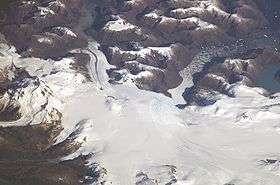 The volcano is visible in the leftmost portion of the image. | |
| Highest point | |
| Elevation | 2,546 m (8,353 ft) [1] |
| Coordinates | 50°20′0″S 73°45′0″W / 50.33333°S 73.75000°W |
| Geography | |
| Location | Chile |
| Parent range | Andes |
| Geology | |
| Mountain type | Stratovolcano |
| Last eruption | 3,000 ± 1,000 years before present, but even more recent activity likely |
| Climbing | |
| First ascent | 2014 |
Aguilera (e. 2546 m/8353 ft.) is a stratovolcano in southern Chile, which rises above the edge of the Southern Patagonian Ice Field. It is a remote volcano that was identified as such in 1985, but the first ascent only occurred in 2014, making it the last unclimbed major Andean volcano.
It is located west of Lake Argentino and northeast of Peel Fjord in the southern Andes and erupted mainly dacites and pyroclastic tephra. It has erupted several times in the Holocene, with a major eruption taking place 3,000 ± 1,000 years before present. Its eruptions have spread ashfalls over Patagonia.
Geography and geomorphology
Aguilera lies west of the city of Calafate,[2] northwest of Peel Fjord.[3] There is not much knowledge on volcanism in southernmost Chile/Patagonia[4] as the volcanoes are poorly mapped, difficult to access and the weather conditions hostile.[5] Aguilera was named in 1933 by Alberto Maria de Agostini, but its volcanic nature was first established in 1985.[6][7]
Aguilera is part of the Andean Austral Volcanic Zone, which lies in the southernmost territory of Chile. It consists of six volcanoes, from north to south these are Lautaro, Viedma, Aguilera, Reclus, Monte Burney and Cook;[8] only the first has clearly documented historical activity, in 1959-1960.[9] The first five are located on the South America Plate at increasing distances from the trench, while Cook is on the Scotia Plate[10] and is a complex of lava domes unlike the other volcanoes which are stratovolcanoes.[11] North of Lautaro lies a 300 kilometres (190 mi) long gap without volcanism and then Cerro Hudson, the southernmost volcano of the Southern Volcanic Zone.[2]
The volcano is a 2,545 metres (8,350 ft)[3]/2,546 metres (8,353 ft) high[1] stratovolcano that rises from the Southern Patagonian Ice Field;[12] the edifice reaches a height of about 1,500 metres (4,900 ft) above its base and is almost entirely covered with ice.[6][7]
Geology
Off southwesternmost South America, the Antarctic Plate subducts beneath the South America Plate at a rate of 2–2.5 centimetres per year (0.79–0.98 in/year). This subduction is responsible for the volcanism in the Austral Volcanic Zone,[8][4] whereas earthquake activity is low; this is possibly because the subducting plate is too hot and too slow moving.[10]
The basement below Aguilera is of Paleozoic-early Mesozoic age and consists of metamorphic rocks. The volcano sits at the easterly margin of the Patagonian Batholith, a Mesozoic-Cenozoic igneous rock province.[11]
Volcanism occurs along much of the Andes, partly due to the subduction of the Antarctic Plate and partly due to the subduction of the Nazca Plate, in each case beneath the South America Plate. The latter subduction gives rise to the Northern Volcanic Zone, the Central Volcanic Zone and the Southern Volcanic Zone of the Andes,[13] the Austral Volcanic Zone was once considered part of the Southern Volcanic Zone.[14]
Composition
Aguilera has erupted dacites with intermediate contents of potassium,[4] defining a calc-alkaline suite[15] with adakitic characteristics.[10] Phenocrysts include amphibole, biotite,[15] clinopyroxene,[16] hornblende and plagioclase; plagioclase and also orthoclase and pyroxene often occur as xenoliths.[15]
Melts of subducted sediment and from the subducting slab give rise to the magmas of Aguilera and other volcanoes of the northern Austral Volcanic Zone,[17] but they are subsequently modified by interactions with the mantle wedge[18] and in the case of Aguilera, Lautaro and Viedma further interaction takes place with the Paleozoic crust.[19][20]
Climate and vegetation
Aguilera lies within the Southern Hemisphere Westerlies belt and the average temperature of the region is about 4–10 °C (39–50 °F). There is a west-east precipitation gradient from 1,400 millimetres per year (55 in/year) to less than 200 millimetres per year (7.9 in/year) in the region; frontal systems and cyclones within the westerlies deliver most precipitation in the region, but precipitation rates are controlled by orographic precipitation and the rainshadow effect resulting in the west-east gradient.[21]
Vegetation in the region ranges from Magellanic subpolar forests to semidesert, depending on the amount of moisture available; Nothofagus species form most of the woods, including Nothofagus antarctica, Nothofagus betuloides and Nothofagus pumilio.[21]
Eruption history
Aguilera erupted during the Holocene, depositing tephra in the region of Lago Argentino and Torres del Paine.[22] The composition of rocks erupted by Aguilera are similar to these from Lautaro and Viedma, and the linkage of specific ash deposits to Aguilera is based mainly on geographical considerations.[23] Other volcanoes have left tephra deposits in the wider region, including Cerro Hudson, Monte Burney and Reclus.[24]
A 70 millimetres (2.8 in) thick tephra from Laguna Potrok Aike may testify to an eruption of Aguilera between 42,400 - 51,747 years before present.[25] Later, two ash layers emplaced 5,700 and 5,150 years before present in the Vega Ñandú mire in Torres del Paine National Park may have been erupted at Aguilera.[26] A tephra layer found at archeological sites around Lago Argentino and deposited there 4,091 - 4,566 years before present originated at Aguilera and probably disrupted local human communities.[27] Farther away in Antarctica, a tephra found in Talos Dome and deposited there 4,420 years before present may have originated at this volcano as well.[28]
Another smaller eruption occurred at Aguilera after the A1 event and deposited ash in the Lago Argentino area; the date of its eruption is unknown.[29] There are no known historical eruptions.[30]
A1 eruption
A major eruption occurred at Aguilera less than 3,596 ± 230 years before present,[24] it was later constrained to have occurred 3,000 ± 100 years before present, and is known as the A1 eruption of Aguilera.[31] It was a large eruption and deposited tephra east of the volcano[24] and as far south as the Strait of Magellan. Its volume has been estimated to be between 3.6–9.5 cubic kilometres (0.86–2.28 cu mi),[32] and it is classified as level 5 on the volcanic explosivity index.[1]
Tephra deposits from this eruption have been found in the Cordillera Baguales (6–8 centimetres (2.4–3.1 in) thickness),[33] at Gran Campo Nevado (1.5 millimetres (0.059 in) thickness),[24] Lago Argentino (6–8 centimetres (2.4–3.1 in) thickness), Lago Cardiel (1 centimetre (0.39 in) thickness), Lago Roca (10 centimetres (3.9 in) thickness), Lake Viedma (2 centimetres (0.79 in) thickness), Brunswick Peninsula (1 centimetre (0.39 in) thickness), Seno Skyring (2 centimetres (0.79 in)), Torres del Paine National Park (2–3 centimetres (0.79–1.18 in) thickness).[33] Furthermore, a sulfur dioxide-rich layer in ice cores from Talos Dome, Antarctica, dated to 3,600 years before present may have been a consequence of the Aguilera eruption.[24]
First climb
Aguilera was the last major volcano in the Andes to be climbed, with the first successful attempt occurring in August 2014 by a group of Chilean climbers.[7][6]
References
- 1 2 3 "Aguilera". Global Volcanism Program. Smithsonian Institution.
- 1 2 Kilian 1990, p. 302.
- 1 2 Harambour 1988, p. 178.
- 1 2 3 Kilian 1990, p. 301.
- ↑ Harambour 1988, p. 173.
- 1 2 3 Griffin, Lindsay (1 October 2014). "Winter in Patagonia - a coveted first ascent of Aguilera". www.thebmc.co.uk. British Mountaineering Council.
- 1 2 3 Rada, Camilo (23 September 2014). "Volcan Aguilera, first ascent in Patagonia by the Uncharted expedition". PlanetMountain.com. Retrieved 24 January 2018.
- 1 2 Kilian 1994, p. 477.
- ↑ Stern 2008, p. 435.
- 1 2 3 Stern & Kilian 1996, p. 264.
- 1 2 Stern & Kilian 1996, p. 265.
- ↑ Perucca, Laura; Alvarado, Patricia; Saez, Mauro (1 July 2016). "Neotectonics and seismicity in southern Patagonia". Geological Journal. 51 (4): 553. doi:10.1002/gj.2649. ISSN 1099-1034.
- ↑ Stern, Futa & Muehlenbachs 1984, p. 31.
- ↑ Stern, Futa & Muehlenbachs 1984, p. 32.
- 1 2 3 Kilian 1990, p. 303.
- ↑ Stern & Kilian 1996, p. 267.
- ↑ Stern & Kilian 1996, p. 278.
- ↑ Stern & Kilian 1996, p. 280.
- ↑ Stern, Futa & Muehlenbachs 1984, p. 42.
- ↑ Kilian 1994, p. 478.
- 1 2 Tonello, Mancini & Seppä 2009, p. 411.
- ↑ Tonello, Mancini & Seppä 2009, p. 413.
- ↑ Stern 2008, p. 441.
- 1 2 3 4 5 Kilian, Rolf; Hohner, Miriam; Biester, Harald; Wallrabe-Adams, Hans J.; Stern, Charles R. (2003). "Holocene peat and lake sediment tephra record from the southernmost Chilean Andes (53-55°S)". Revista geológica de Chile. 30 (1): 23–37. doi:10.4067/S0716-02082003000100002. ISSN 0716-0208.
- ↑ Wastegård, S.; Veres, D.; Kliem, P.; Hahn, A.; Ohlendorf, C.; Zolitschka, B. (July 2013). "Towards a late Quaternary tephrochronological framework for the southernmost part of South America – the Laguna Potrok Aike tephra record". Quaternary Science Reviews. 71: 84. doi:10.1016/j.quascirev.2012.10.019. ISSN 0277-3791.
- ↑ Villa-Martínez, Rodrigo; Moreno, Patricio I. (November 2007). "Pollen evidence for variations in the southern margin of the westerly winds in SW patagonia over the last 12,600 years". Quaternary Research. 68 (03): 404. doi:10.1016/j.yqres.2007.07.003. ISSN 0033-5894.
- ↑ Franco, Nora Viviana; Borrero, Luis Alberto; Brook, George A.; Mancini, María Virginia (2018). "Changes in the Technological Organization and Human Use of Space in Southern Patagonia (Argentina) During the Late Holocene". Lithic Technological Organization and Paleoenvironmental Change. Springer, Cham: 308–309. doi:10.1007/978-3-319-64407-3_14.
- ↑ Narcisi, Biancamaria; Petit, Jean Robert; Delmonte, Barbara; Scarchilli, Claudio; Stenni, Barbara (August 2012). "A 16,000-yr tephra framework for the Antarctic ice sheet: a contribution from the new Talos Dome core". Quaternary Science Reviews. 49: 61. doi:10.1016/j.quascirev.2012.06.011. ISSN 0277-3791.
- ↑ Stern 2008, p. 450.
- ↑ Martinic, Mateo (1 December 1988). "Actividad volcanica historica en la Region de Magallanes". Andean Geology (in Spanish). 15 (2): 184. ISSN 0718-7106.
- ↑ Stern 2008, p. 449.
- ↑ Stern 2008, p. 452.
- 1 2 Stern 2008, p. 445.
Sources
- Harambour, Salvador M. (1988-12-01). "Sobre el hallazgo del mitico volcan Reclus, ex Mano del Diablo, Hielo Patagonico Sur, Magallanes, Chile". Andean Geology (in Spanish). 15 (2): 173–179. doi:10.5027/andgeoV15n2-a06. ISSN 0718-7106.
- Kilian, R. (1990). "The australandean volcanic zone (south Patagonia)". Symposium international "Géodynamique andine" : résumés des communications: 303.
- Kilian, R. (1994). "New Trace Element and Isotopic Constraints on the Genesis of Andesites and Dacites of the Quaternary Austral Volcanic Zone of the Andes". Mineralogical Magazine. 58A (1): 477–478. doi:10.1180/minmag.1994.58A.1.248.
- Stern, C. R.; Futa, K.; Muehlenbachs, K. (1984). "Isotope and Trace Element Data for Orogenic Andesites from the Austral Andes". Andean Magmatism. Birkhäuser Boston: 31–46. doi:10.1007/978-1-4684-7335-3_4.
- Stern, C. R.; Kilian, Rolf (1 April 1996). "Role of the subducted slab, mantle wedge and continental crust in the generation of adakites from the Andean Austral Volcanic Zone". Contributions to Mineralogy and Petrology. 123 (3): 263–281. doi:10.1007/s004100050155. ISSN 0010-7999.
- Stern, Charles R. (1 February 2008). "Holocene tephrochronology record of large explosive eruptions in the southernmost Patagonian Andes". Bulletin of Volcanology. 70 (4): 435–454. doi:10.1007/s00445-007-0148-z. ISSN 0258-8900.
- Tonello, Marcela Sandra; Mancini, Maria Virginia; Seppä, Heikki (November 2009). "Quantitative reconstruction of Holocene precipitation changes in southern Patagonia". Quaternary Research. 72 (03): 410–420. doi:10.1016/j.yqres.2009.06.011. ISSN 0033-5894.