Public transport in Auckland
|
| |
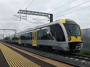 An AT electric train | |
| Parent | Auckland Transport (AT) |
|---|---|
| Locale | New Zealand |
| Service area | Auckland Region |
| Service type | Bus, rail, ferry |
| Hubs | Britomart Transport Centre |
| Website | at.govt.nz |
Public transport in Auckland, the largest metropolitan area of New Zealand, consists of three modes: bus, train and ferry. Services are coordinated by Auckland Transport under the AT Metro brand. Britomart Transport Centre is the main transport hub.
Until the 1950s Auckland was well served by public transport and had high levels of ridership.[1] However, the dismantling of an extensive tram system in the 1950s, the decision by William Goosman[2] to not electrify Auckland's rail network, and a focus of transport investment into a motorway system led to the collapse in both mode share and total trips.[3] By the 1990s Auckland had experienced one of the sharpest declines in public transport ridership in the world, with only 33 trips per capita per year.[4]
Since 2000, a greater focus has been placed on improving Auckland's public transport system through a series of projects and service improvements. Major improvements include the Britomart Transport Centre, the Northern Busway, the upgrade and electrification of the rail network[5] and the introduction of integrated ticketing through the AT Hop Card. These efforts have led to sustained growth in ridership, particularly on the rail network. Between June 2005 and November 2017 total ridership increased from 51.3 million boardings per annum to 90.9 million.[6]
Despite those strong gains, the overall share of travel in Auckland by public transport is still quite low. At the 2013 census around 8% of journeys to work were by public transport[7] and per capita ridership in 2017 of around 55 boardings is still well below that of Wellington, Sydney, Melbourne, Perth and most large Canadian cities.[8]
Auckland's rapid population growth means that improving the city's public transport system is a priority for Auckland Council[9] and the New Zealand Government.[10] Major improvements planned or underway include the City Rail Link,[11] extending the Northern Busway to Albany,[12] construction of an Eastern Busway between Panmure and Botany, and the proposed Auckland Airport Line, a light rail line between the city centre and Auckland Airport.[13]
History
Pre World War II growth
Horse-drawn trams operated in Auckland from 1884 while the Auckland Electric Tram Company's system was officially opened on 17 November 1902.[14] The Electric Tram Company started as a private company before being acquired by Auckland City Council.
The tram network enabled and shaped much of Auckland's growth throughout the early 20th century. Auckland's public transport system was very well utilised, with usage peaking at over 120 million boardings during the Second World War, even though Auckland's population was under 500,000 at the time.[15]
Post World War II decline
Auckland's extensive tram network was removed in the 1950s, with the last line closing in late 1956.[16][17] Although a series of ambitious rail schemes were proposed between the 1940s and 1970s,[18] the focus of transport improvements in Auckland shifted to developing an extensive motorway system. Passionate advocacy from long-time Mayor of Auckland City Council Dove-Myer Robinson for a "rapid rail" scheme was ultimately unsuccessful.[19]
Removal of the tram system, little investment in Auckland's rail network and growing car ownership in the second half of the 20th century led to a collapse in ridership across all modes of public transport.[3] From a 1954 average level of 290 public transport trips per person per year (a share of 58% of all motorised trips), patronage decreased rapidly.[8][20] 1950s ridership levels were only reached again in the 2010s, despite Auckland's population growing four-fold over the same time period.[3]
These decisions also shaped Auckland's growth patterns in the late 20th century, with the city becoming a relatively low-density dispersed urban area with a population highly dependent on private vehicles for their travel needs.[21] By the late 1990s ongoing population growth and high levels of car use were leading to the recognition that traffic congestion was one of Auckland's biggest problems.[22]
Privatisation
It has been claimed that the city's public transport decline resulted from, "privatisation, a poor regulatory environment and a funding system that favours roads".[23] On the other hand, NZ Bus claim that increasing passengers and cost control began with privatisation in 1991.[24]
21st century revival
As concerns over urban sprawl and traffic congestion grew in the 1990s and early 2000s, public transport returned to the spotlight, with growing agreement of the "need for a substantial shift to public transport".[25] Growing recognition that Auckland could no longer "build its way out of congestion" through more roads alone led to the first major improvements to Auckland's public transport system in half a century:
- The Britomart Transport Centre was opened in 2003, the first major upgrade of Auckland's rail network since World War II. This project allowed trains to reach into the heart of Auckland's city centre and acted as a catalyst for the regeneration of this part of downtown Auckland.[26]
- The Northern Busway was opened in 2008, providing Auckland's North Shore with rapid transit that enabled bus riders to avoid congestion on the Northern Motorway and Auckland Harbour Bridge.[27]
- A core upgrade of Auckland's rail network between 2006 and 2011, known as Project DART, which included double-tracking of the Western Line, the reopening of the Onehunga Branch line to Onehunga, a rail spur to Manukau City and a series of station upgrades.[28]
- Electrification of the Auckland rail network (except for the section of track between Papakura and Pukekohe) and the purchase of new electric trains from Spanish manufacturer CAF. Electric train services commenced in 2014.
- Implementation of an integrated ticketing and fares system, through the AT HOP card, enabling consistent fares and easy transfers between different bus, train and ferry operators.
Despite these improvements, the lack of investment in Auckland's public transport system throughout the latter part of the 20th century means the city still has much lower levels of ridership than other major cities in Canada and Australia.[29] Auckland's ongoing strong population growth and constrained geography means that Auckland's transport plans now have a strong focus on further improving the quality and attractiveness of public transport.[30] Further improvements are to be realised in the years to 2028 under the Auckland Transport Alignment Project (ATAP), valued at NZ$28 billion[31] ($4.6 billion more than previously planned), of which $9.1 billion is for additional public transport projects, including: the completion of the City Rail Link; the construction of the Eastern Busway, which would run from Panmure to Botany; Northern Busway extension to Albany; the extension of the railway electrification to Pukekohe; third main line between Westfield and Wiri; further new electric trains and the construction of a light rail network to the northwest (to be designed) and to the airport.[32]
Buses
Urban services

Buses provide for around 70% of public transport trips in Auckland.[6] Bus services generally run from around 6am to midnight, with a limited number of buses linking Auckland's suburbs and city centre after midnight on Friday and Saturday nights only, with Northern Express services on the Northern Busway on the North Shore running half-hourly until 3:00 a.m.[33]
Services are contracted by Auckland Transport and operated by a number of private companies, including:
- Bayes Coachlines
- Birkenhead Transport Limited
- Go Bus
- Howick and Eastern Buses Limited
- NZ Bus
- Pavlovich Coachlines
- Ritchies Transport
- Tranzurban Auckland (Tranzit Group) – contracted operator of NX2 services on the Northern Busway[34]
- Waiheke bus company (by Fullers, 5 routes)
Auckland Transport began rebranding bus services to AT Metro in 2014–2015 to create a single identity for all bus services, with some exceptions like the Link buses which retained their red, green and orange colours.[35] Some buses still appear in their respective companies' livery as of October 2018.
There are four Link services; all accept fare payment by AT Hop card or cash and all run from early morning to late evening, 7 days of the week.[36]
- CityLink – red buses – both way loop; Wynyard Quarter – Queen Street – Karangahape Road – Queen Street – Wynyard Quarter.
- InnerLink – green buses – both way loop; Britomart – Parnell – Newmarket – Karangahape Road – Ponsonby Road – Victoria Park – Britomart.
- OuterLink – amber buses – both way loop; Wellesley Street – Parnell – Newmarket – Mount Eden – Mount Albert – Westmere – Herne Bay – Wellesley Street.
- TāmakiLink – blue buses – both way loop; Britomart – Spark Arena – Okahu Bay – Kelly Tarlton's Sea Life Aquarium – Mission Bay – Kohimarama Beach – St Heliers Bay – Glen Innes.
SkyBus provides services between Auckland Airport and both Albany and the Auckland CBD.
Bus priority facilities

Auckland has a growing number of bus lanes, some of which operate at peak times only and others 24 hours a day. These lanes are for buses and two-wheeled vehicles only and are intended to reduce congestion and shorten travel times. All are sign-posted and marked on the road surface.
The Central Connector bus lane project improved links between Newmarket and the inner city, while bus lanes are also planned on Remuera Road and St Johns Road to connect the city with the Eastern Bays suburbs.
The Northern Busway provides complete separation for buses from general traffic between Akoranga (near Takapuna) and Constellation Drive. This busway is to be extended further north to Albany Busway Station[37] and in the longer term is planned to be further extended to Hibiscus Coast Busway Station, and Orewa.[38]
Other planned busways include the Eastern Busway between Panmure and Botany, the Northwestern Busway[39] between Westgate and the city centre (possibly to be built as light-rail instead of a busway[10]) and a bus connection between Auckland Airport, Manukau City and Botany.[10]
Long-distance services
Long-distance bus operator Intercity links Auckland with all the main centres in the North Island.[40]
Trains


Urban services
Auckland's urban train services are operated under the AT brand by Transdev Auckland. Trains and stations are owned by Auckland Transport while tracks and other rail infrastructure are owned by KiwiRail.
Since the opening of Britomart Transport Centre, significant improvements have been made to commuter rail services. These include:
- Sunday services were reintroduced in October 2005 for the first time in over 40 years, together with a general 25% service frequency increase.[41]
- Project DART upgraded the core rail network between 2006 and 2012, including double-tracking the Western Line (completed in 2010),[42] constructing the Manukau Branch line from Wiri to Manukau City Centre (completed 2012), rebuilding and reconfiguring Newmarket Train Station (completed 2010) and reopening the disused Onehunga Branch line for passengers[43] (reopened September 2010)
- Electrification of the rail network from Swanson station on the Western Line and Papakura station on the Southern Line and the purchase of 57 electric trains. The first passenger services operated in April 2014.[44]
- Otahuhu Railway Station was extensively rebuilt to connect with a new bus interchange being built alongside. In October 2016 the interchange was opened to coincide with the launching of a new bus network timetable in South Auckland, Pukekohe and Waiuku.[45]
- The new Manukau bus station (next to Manukau railway station) was officially opened in April 2018 and bus services from the new facility began, serving South and East Auckland.[46][47]
These improvements have led to rapid growth in rail ridership, from a low of 1 million annual boardings in 1994 to over 20 million in 2017.[48] Increasing train frequencies to meet further growth is not possible because of the "dead end" at Britomart train station which means all trains entering and exiting the station need to use the same two tracks. The City Rail Link project, due to be opened in 2023 is an underground tunnel between Britomart to Mount Eden station designed to address these constraints, provide greater route flexibility across the entire network, and create a more direct route for Western Line services.[49]
Services
There are four commuter rail lines:
| Line | Frequency (off-peak) | Calling at | Notes | |
|---|---|---|---|---|
| Eastern Line | 3 tph (Mo-Fr) 2 tph (Sa-Su) |
Britomart, Orakei, Meadowbank, Glen Innes, Panmure, Sylvia Park, Otahuhu, Middlemore, Papatoetoe, Puhinui, Manukau | ||
| Southern Line | 3 tph (Mo-Fr) 2 tph (Sa-Su) |
Britomart, Parnell, Newmarket, Remuera, Greenlane, Ellerslie, Penrose, Otahuhu, Middlemore, Papatoetoe, Puhinui, Homai, Manurewa, Te Mahia, Takanini, Papakura | ||
| Southern Line (Papakura–Puhekohe shuttle) | 1 tph | Papakura, Pukekohe | Diesel shuttle connecting with service to/from Britomart | |
| Western Line | 3 tph (Mo-Fr) 2 tph (Sa-Su) |
Britomart, Parnell, Newmarket, Grafton, Mount Eden, Kingsland, Morningside, Baldwin Avenue, Mount Albert, Avondale, New Lynn, Fruitvale Road, Glen Eden, Sunnyvale, Henderson, Sturges Road, Ranui, Swanson | Trains reverse at Newmarket. | |
| Onehunga Line | 2 tph | Britomart, Newmarket, Remuera†, Greenlane†, Ellerslie, Penrose, Te Papapa, Onehunga | ||
| tph = trains per hour † station served at evenings only | ||||
Rolling stock
| Class | Image | Type | Top speed | Number | Carriages | Routes operated | Built | |
|---|---|---|---|---|---|---|---|---|
| km/h | mph | |||||||
| AM class | |
EMU | 110 | 68 | 57 | 3 | Eastern Line Onehunga Line Southern Line (Britomart–Papakura) Western Line |
2013–15 |
| ADL/ADC class |  |
DMU | 90 | 56 | 10 | 2 | Southern Line (Papakura–Pukekohe) | 1982–85 |
Long-distance services
Auckland has only one long-distance passenger train, the Northern Explorer to Wellington, operated by KiwiRail Scenic Journeys. It runs southbound on Mondays, Thursdays and Saturdays and northbound Tuesdays, Fridays and Sundays. The service is mainly tourist-oriented.
Future upgrades
A number of upgrades and extensions to the rail network have been proposed, some for several decades:
- The Auckland Airport Line, an extension of the Onehunga Branch line to Auckland International Airport over the Mangere Bridge
- An airport link from the North Island Main Trunk line at Manukau City, in addition to or instead of a link via Mangere Bridge
- Extension of electrification to Pukekohe (including new stations at Drury, Drury West and Paerata[50] and eventually to Hamilton allowing inter-city commuting[51][52]
- The Avondale-Southdown Line, a line between Avondale in west Auckland and the Southdown Freight Terminal, to allow freight trains to avoid Newmarket and reduce delays for both freight and passenger trains.[53]
- A "third Main line" between Wiri and Westfield to allow freight trains to bypass stationary passenger trains on that section.[54]
- Extension of rail across Waitematā Harbour to the North Shore[55] and possible conversion of the Northern Busway to light rail[10]
- Extension of Western Line rail services to Kumeu.
Ferries
History
The first official ferry started in 1854, the first steam ferry in 1860,[56] the first scheduled ferry in 1865, Auckland & North Shore Steam Ferry Co in 1869, Devonport Steam Ferry Company in 1885, a vehicle ferry in 1911 and North Shore Ferries in 1959.[57]
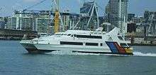
In 1981 George and Douglas Hudson bought North Shore Ferries and Waiheke Shipping Co. In 1984 they founded Gulf Ferries, and their first catamaran, the $3m Quickcat, cut the Waiheke ferry time from 75 minutes to 40,[58] with Fullers putting Kea on the Devonport route from 1988.[57] Fullers Corporation was mainly operating cruises and, in 1987, when they introduced Supercat III,[59] they were refused a licence to compete on Waiheke commuter trips.[60] The Hudsons bought Fullers from its 1988 receivership[61] and formed Fullers Group Ltd, in 1994 and Stagecoach took a majority holding in 1998.[62] In 2009, Souter Holdings purchased Fullers Group and also 360 Discovery Cruises.[63]

Services
Around 7 million ferry trips per year[6] are made in Auckland, on a variety of routes radiating from downtown Auckland. Ferry service operators are:
- Fullers Ferry
- Pine Harbour Ferry (services to/from Pine Harbour)
- 360 Discovery
- SeaLink
- Belaire (West Harbour and Rakino Island)
Terminals
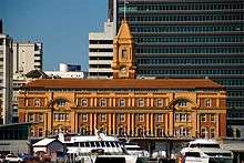
The Auckland Ferry Terminal is in downtown Auckland on Quay Street, between Princes Wharf and the container port, directly opposite Britomart Transport Centre.
- North Shore terminals: Devonport, Stanley Bay, Bayswater, Northcote Point, Birkenhead, Beach Haven, Gulf Harbour
- East Auckland terminals: Half Moon Bay, Pine Harbour
- Waitematā Harbour's western terminals: West Harbour, Hobsonville
Ferries also connect the city with islands of the Hauraki Gulf. Regular sailings serve Waiheke Island, with less frequent services to Great Barrier Island, Rangitoto Island, Motutapu Island and other inner-gulf islands, primarily for tourism.
There are no ferry services on the west coast of Auckland, although there were some historical services from Onehunga. None are planned, as the city's waterfront orientation is much stronger toward the (eastern) Waitematā Harbour than to the (western) Manukau Harbour.
Ticketing and fares
An integrated ticketing / smartcard system, known as the AT HOP Card, was developed for Auckland by Thales, similar to systems like Octopus card in Hong Kong.[64][65]
The first stage of integrated ticketing came online in time for the Rugby World Cup 2011, with construction works for the 'tag on' / 'tag off' infrastructure having begun in January 2011.[66] The 'HOP Card' was publicised with a $1 million publicity campaign that started in early 2011.[65]
The AT HOP card system went live in October 2012 for trains, November 2012 for ferries and between June 2013 and March 2014 for buses.[67]
In 2016, Auckland Transport simplified fares by changing to a system based on 13 fare zones. The fare is no longer based on the distance travelled (number of stages), but on the number of zones passed through, so that a journey in a zone that involves multiple rides or even a mode mix (bus or train) will be charged only one fare.[68] Ferries are not included in the simplified fares system and are charged per ride.
Public advocacy
A number of groups advocate for improving public transport in Auckland. Some groups operate prominent blogs, participate in public discussions on social media and prepare plans advocating for particular improvements. These groups include:
- Greater Auckland[69]
- Campaign for Better Transport[70]
- Public Transport Users Association[71]
- Generation Zero
See also
References
- ↑ "Public transport patronage the highest in more than 60 years". OurAuckland. Retrieved 2017-12-26.
- ↑ "Sir Dove-Myer Robinson on his Rapid Transit Scheme – Part 4". transportblog.co.nz. 2016-05-18. Retrieved 2016-05-19.
- 1 2 3 "Michael Lee: Sins of the fathers - legacy of harbour bridge". The New Zealand Herald. 1 June 2009. Retrieved 4 November 2011.
- ↑ Mees, Paul (February 2001). "The American Heresy: Half a century of transport planning in Auckland".
- ↑ "Developing Auckland's Rail Transport - DART". KiwiRail. Retrieved 29 April 2018.
- 1 2 3 "Auckland Transport Patronage Report".
- ↑ "Journey to Work Patterns in the Auckland Region | Ministry of Transport". www.transport.govt.nz. Retrieved 2017-12-26.
- 1 2 Auckland's Transport Challenges Archived 25 May 2010 at the Wayback Machine. (from the Draft 2009/10-2011/12 Auckland Regional Land Transport Programme, Page 8), ARTA, March 2009. Retrieved 10 April 2009.
- ↑ Council, Auckland. "Mayor Phil Goff's vision for Auckland". Auckland Council. Retrieved 2017-12-26.
- 1 2 3 4 @BernardOrsman, Bernard Orsman Super City reporter, NZ Herald bernard orsman@nzherald co nz (2017-08-06). "Jacinda Ardern outlines Labour's light rail plan for Auckland". NZ Herald. ISSN 1170-0777. Retrieved 2017-12-26.
- ↑ "Nine millionth rail passenger arrives at Britomart". The New Zealand Herald. 3 December 2010. Retrieved 7 February 2011.
- ↑ Agency, NZ Transport. "Auckland Northern Corridor | NZ Transport Agency". www.nzta.govt.nz. Retrieved 2017-12-26.
- ↑ Auckland Transport (24 March 2017). "Airport and Mangere Rail".
- ↑ Digital, Born. "MOTAT Tramway Collection|Museum of Transport and Technology|Auckland". Motat. Retrieved 2017-12-26.
- ↑ "More PT ridership milestones - Greater Auckland". Greater Auckland. 2017-10-19. Retrieved 2017-12-26.
- ↑ Auckland Tram - Number 11 (from the MOTAT website)
- ↑ A Wheel on Each Corner, The History of the IPENZ Transportation Group 1956-2006 - Douglass, Malcolm; IPENZ Transportation Group, 2006, Page 12
- ↑ @AmeliaJWade, Amelia Wade Reporter, NZ Herald amelia wade@nzherald co nz (2016-05-31). "Rail Link 100 years in the making". NZ Herald. ISSN 1170-0777. Retrieved 2017-12-26.
- ↑ History of Auckland City - Chapter 4 Archived 13 May 2008 at the Wayback Machine. (from the Auckland City Council website. Retrieved 7 June 2008.)
- ↑ Mees, Paul (December 2009). Transport for Suburbia: Beyond the Automobile Age. Earthscan Ltd. ISBN 1-84407-740-3.
- ↑ Ministry of Transport. "Auckland Transport Alignment Project - Foundation Report" (PDF).
- ↑ Auckland City Council. "Central Transit Corridor Project". Archived from the original on 22 May 2007. Retrieved 28 June 2007.
- ↑ "Why Is Auckland's Public Transport System So Poor? | Scoop News". www.scoop.co.nz. Retrieved 2018-02-25.
- ↑ "NZ Bus" (PDF). 2008.
- ↑ Dearnaley, Mathew (23 April 2007). "Force people out of cars, says Treasury". The New Zealand Herald. Retrieved 4 November 2011.
- ↑ "Britomart - Auckland | Ministry for the Environment". www.mfe.govt.nz. Retrieved 2017-12-26.
- ↑ Busway FAQ on North Shore City Council website. Retrieved 11 January 2008
- ↑ KiwiRail. "DART - KiwiRail". www.kiwirail.co.nz. Retrieved 2017-12-26.
- ↑ Wallis, Ian (15 August 2011). "Auckland Passenger Transport Performance Benchmark Study" (PDF).
- ↑ "Auckland Transport Alignment Project | Ministry of Transport". www.transport.govt.nz. Retrieved 2017-12-26.
- ↑ "What you need to know about the $28b Auckland Transport Alignment Project". Stuff.co.nz. 26 April 2018. Retrieved 28 April 2018.
- ↑ "Auckland Transport Alignment Project" (PDF). Auckland Council. April 2018.
- ↑ "Northern Express" (PDF). Auckland Transport. Retrieved 29 July 2017.
- ↑ "About Us | Tranzurban". Tranzurban. 2018. Retrieved 2 October 2018.
Tranzurban is the newest addition to Tranzit Group and will operate a part of the new North Shore bus network from September 2018 in collaboration with Auckland Transport.
- ↑ "AT Metro brand makes its debut". Auckland Transport. 16 December 2014. Retrieved 11 June 2016.
- ↑ "Link bus service". Auckland Transport. Retrieved 8 July 2018.
- ↑ "Northern Corridor Newsletter - August 2015 21 August 2015" (PDF). New Zealand Transport Agency. 21 August 2015. Retrieved 23 July 2017.
- ↑ Transport, Auckland. "Supporting growth in the north". Auckland Transport. Retrieved 2017-12-26.
- ↑ @BernardOrsman, Bernard Orsman Super City reporter, NZ Herald bernard orsman@nzherald co nz (2016-09-15). "Northwestern busway to get green light". NZ Herald. ISSN 1170-0777. Retrieved 2017-12-26.
- ↑ Bookings (from the Intercity website. Retrieved 16 February 2008.)
- ↑ Dearnaley, Mathew (11 October 2005). "Sunday trains come back to Auckland". The New Zealand Herald. Retrieved 12 January 2011.
- ↑ "Auckland's rail renaissance". Region Wide. Auckland Regional Council. July 2010. p. 3.
- ↑ Dearnaley, Mathew (14 March 2007). "Delight at Government's decision to reopen Onehunga line". The New Zealand Herald. Retrieved 4 November 2011.
- ↑ "'Stunning' electric trains launched - but soon face delays". NZ Herald. 2014-04-27. ISSN 1170-0777. Retrieved 2017-12-26.
- ↑ "Otahuhu's new transport hub the 'way to go' - Goff". 29 October 2016. Retrieved 26 March 2017.
- ↑ "$49m bus station opens in Manukau". RNZ News. 7 April 2018. Retrieved 10 April 2018.
- ↑ "Manukau's new bus station opens". Auckland Transport. Retrieved 5 April 2018.
- ↑ "Auckland train patronage anticipated to hit 60 million". Stuff. Retrieved 2017-12-26.
- ↑ "Pukekohe to Huapai rail line suggested". NZ Herald. 27 February 2017. Retrieved 17 March 2017.
- ↑ Transport, Auckland. "Supporting growth in the south". Auckland Transport. Retrieved 2017-12-26.
- ↑ Electric train lines may reach Hamilton - The New Zealand Herald, Thursday 28 February 2008
- ↑ "Introducing Regional Rapid Rail - Greater Auckland". Greater Auckland. 2017-08-17. Retrieved 2017-12-26.
- ↑ "Auckland Council threaten KiwiRail with Environment Court action". Stuff.co.nz. 28 November 2016. Retrieved 29 July 2017.
- ↑ "Rail proposal that Minister's office tried to block released". Radio New Zealand. 2017-06-15. Retrieved 2017-07-04.
- ↑ Rudman, Brian (11 July 2007). "Brian Rudman: Hallelujah, talk before bulldozers". The New Zealand Herald. Retrieved 4 November 2011.
- ↑ "Waitemata ferries remembered at Devonport Library". timespanner.blogspot.co.nz. Retrieved 2018-02-25.
- 1 2 "North Shore Heritage - Thematic Review Report" (PDF). Auckland Council. July 2011. ISBN 978 1 927169 23 0.
- ↑ "Captain magazine, summer 2015". Issuu. Retrieved 2018-02-25.
- ↑ "New Zealand Maritime Index from NZNMM". www.nzmaritimeindex.org.nz. Retrieved 2018-02-25.
- ↑ Brlan Baxter, Fergus Gammie (1988). "REVIEW OF NZ PASSENGER LICENSING SYSTEM" (PDF).
- ↑ Pedersen, Roy (2013-09-01). Who Pays the Ferryman?. Birlinn. ISBN 9780857906038.
- ↑ Butler, Michael. "Omnibus Society - Hino RB145 buses". www.omnibus.org.nz. Retrieved 2018-02-25.
- ↑ "Our History". FullersFerries. Retrieved 2018-02-25.
- ↑ "Integrated ticketing". Region Wide. Auckland Regional Council. July 2010. p. 3.
- 1 2 Dearnaley, Mathew (24 December 2010). "$1m budget to help publicise Hop Card". The New Zealand Herald. Retrieved 30 January 2011.
- ↑ "Start Of Construction For Integrated Ticketing". Press Release, Auckland Transport. 24 January 2011. Retrieved 30 January 2011.
- ↑ "Planned bus roll-out schedule". Auckland Transport. Retrieved 30 March 2014.
- ↑ "Fare zones & calculating how much you pay". Auckland Transport. Retrieved 8 September 2017.
- ↑ "Greater Auckland". Retrieved 30 September 2018.
- ↑ "The Campaign For Better Transport". Retrieved 30 September 2018.
- ↑ "Public Transport Users Association of New Zealand". Retrieved 30 September 2018.
External links
- Auckland Transport (website of the region's local government transport body)
- ONTRACK New Zealand Railways Corporation (Rere Totika), the government rail owner
- Wheel Traffic (Tramways etc) in Cyclopaedia of New Zealand Volume II (Auckland) of 1902
- Photos of Downtown Municipal Transport Centre (now Britomart) in 1940s to 1970s