Northern Busway, Auckland
| Northern Busway | |||||||||||||||||||||||||||||||||||||||||||||||||||||||||||||||||||||||||||||||||||||||||||||||||||||||||||||||||||
|---|---|---|---|---|---|---|---|---|---|---|---|---|---|---|---|---|---|---|---|---|---|---|---|---|---|---|---|---|---|---|---|---|---|---|---|---|---|---|---|---|---|---|---|---|---|---|---|---|---|---|---|---|---|---|---|---|---|---|---|---|---|---|---|---|---|---|---|---|---|---|---|---|---|---|---|---|---|---|---|---|---|---|---|---|---|---|---|---|---|---|---|---|---|---|---|---|---|---|---|---|---|---|---|---|---|---|---|---|---|---|---|---|---|---|---|
 Passengers boarding an Auckland Transport Northern Express service operated by Ritchies Transport | |||||||||||||||||||||||||||||||||||||||||||||||||||||||||||||||||||||||||||||||||||||||||||||||||||||||||||||||||||
| Overview | |||||||||||||||||||||||||||||||||||||||||||||||||||||||||||||||||||||||||||||||||||||||||||||||||||||||||||||||||||
| Type | Busway | ||||||||||||||||||||||||||||||||||||||||||||||||||||||||||||||||||||||||||||||||||||||||||||||||||||||||||||||||||
| Status | Open | ||||||||||||||||||||||||||||||||||||||||||||||||||||||||||||||||||||||||||||||||||||||||||||||||||||||||||||||||||
| Locale | North Shore, Auckland | ||||||||||||||||||||||||||||||||||||||||||||||||||||||||||||||||||||||||||||||||||||||||||||||||||||||||||||||||||
| Termini |
Constellation(Busway Lanes), Hibiscus Coast Akoranga | ||||||||||||||||||||||||||||||||||||||||||||||||||||||||||||||||||||||||||||||||||||||||||||||||||||||||||||||||||
| Stations | 6 | ||||||||||||||||||||||||||||||||||||||||||||||||||||||||||||||||||||||||||||||||||||||||||||||||||||||||||||||||||
| Services | NX1, NX2, 83, 866 | ||||||||||||||||||||||||||||||||||||||||||||||||||||||||||||||||||||||||||||||||||||||||||||||||||||||||||||||||||
| Operation | |||||||||||||||||||||||||||||||||||||||||||||||||||||||||||||||||||||||||||||||||||||||||||||||||||||||||||||||||||
| Opened | 2008 | ||||||||||||||||||||||||||||||||||||||||||||||||||||||||||||||||||||||||||||||||||||||||||||||||||||||||||||||||||
| Owner | Auckland Transport | ||||||||||||||||||||||||||||||||||||||||||||||||||||||||||||||||||||||||||||||||||||||||||||||||||||||||||||||||||
| Operator(s) | AT Metro | ||||||||||||||||||||||||||||||||||||||||||||||||||||||||||||||||||||||||||||||||||||||||||||||||||||||||||||||||||
| Character | Urban rapid transit | ||||||||||||||||||||||||||||||||||||||||||||||||||||||||||||||||||||||||||||||||||||||||||||||||||||||||||||||||||
| |||||||||||||||||||||||||||||||||||||||||||||||||||||||||||||||||||||||||||||||||||||||||||||||||||||||||||||||||||
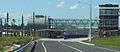
The Northern Busway is a segregated busway that runs along the eastern side of the Northern Motorway, part of State Highway 1, in the north of Auckland, New Zealand, linking the North Shore with the northern end of the Auckland Harbour Bridge. The busway consists of two-way lanes running between Constellation Station and Akoranga Station, and from Akoranga Station a southbound-only lane that joins the harbour bridge approaches just south of the Onewa Road on-ramp system.
Six stations provide access points for passengers to board; some stations have park and ride parking spaces; others have drop off and pick up zones only.
City-bound Northern Express (NX1 and NX2) services commence from Hibiscus Coast Station or Albany Station and travel on local roads to Constellation Station, from where they travel on the dedicated busway lanes; from Albany, the lanes reduced travel time to Britomart Transport Centre from around one hour by car during peak hours to about half an hour by bus.[1] In the reverse direction, NX1 and NX2 services leaving the city travel north to the Akoranga off-ramp, cross over the motorway, and enter Akoranga Station, from where they travel north on the busway lanes. The busway lanes are also an important transport link within the North Shore, where they are the spine of the bus-based public transport system.
History
Concept, design and construction
Concept design for the busway was developed by MRCagney (formerly McCormick Rankin Cagney), with detailed design and consultation completed by Mario Madayag Architecture, Jasmax, Beca Group, Opus and Connell Wagner. Fletcher Construction was responsible for construction. Akoranga, Smales Farm, and Sunnynook stations were built by NZ Strong Construction.[2][3][4]
Difficulties encountered included the nearby residential areas, the predominantly soft ground, and environmental efforts to protect New Zealand dotterel breeding grounds. Construction employed around 300 people at its peak, with around a million man-hours being invested, including shifts during 512 nights.[4][5]
Operation
The busway was officially opened in February 2008[6] after several years of construction, though the Albany and Constellation stations had been operating since December 2005 using the normal Northern Motorway lanes.[7] It was credited with reducing peak traffic on the Northern Motorway by around 500 cars each rush hour one month after opening,[8] and about 39% of passengers on the Northern Express bus service had never used public transport before.[4] The busway was initially used by 70 buses per hour during peak time.[5]
In 2008 the busway received the 'Shell Bitumen Excellence Award for a Major Roading Project' and the 'Roading New Zealand Supreme Award'.[9] In June 2009, it received the Ingenium 'Excellence Award' (in the category for projects above NZ$2 million construction cost).[10]
In June 2010, the busway carried its 5 millionth passenger and was estimated to remove the equivalent of about 5,100 cars in the morning peak, with 80 buses per hour during peak times.[11]
By mid-2011, frequency of the Northern Express had risen to every three minutes during the morning peak hour, five minutes during the 'shoulder peak'.[12]
In 2015, some Northern Express services were extended to Hibiscus Coast Busway Station (formerly named Silverdale Park and Ride).[13]
In 2017, Auckland Transport's projections indicated that the busway would reach maximum capacity in 2026, twenty years earlier than originally expected. AT's report said that increased patronage would "manifest in overcapacity conditions and poor operational performances" at Albany, Sunnynook and Akoranga stations. AT was investigating a range of improvements, including lengthening station platforms. A decision on a timeline for conversion of the busway to a rail link was expected to be announced before the end of 2017.[14] In the 12 months to September 2017, the busway carried 5 million passengers.[15]
Funding
The busway became fully operational in 2009, with some final sections being completed with little publicity, for around NZ$290–294 million: $210 million for the busway and $84 million for the stations.[16][17] The project was funded by Transit New Zealand, ARTA, Auckland City Council and North Shore City Council.[5]
Infrastructure
Busway
The busway has two lanes for 6.2 km[18] running parallel with the eastern side of the Northern Motorway from Constellation Station at the Constellation Drive/Upper Harbour Highway interchange to Akoranga Station at the Esmonde Road interchange,[19] from where a one-way southbound bus lane extends a further 2.5 km to south of the Onewa Road interchange, where it merges with the motorway for the Harbour Bridge.[4] There are no dedicated bus lanes on the harbour bridge itself.
Its use is limited to buses of 25+ seat capacity, emergency and maintenance vehicles,[16] and the SkyBus North Harbour services that run between Albany and Auckland Airport.[20] The busway has been designed for possible use by car pools.[21]
Bus stations
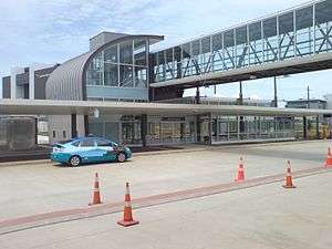
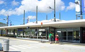
The busway includes six dedicated stations, some with extensive park-and-ride car parks. Feeder bus services serve the stations, allowing transfer.
The stations are (north to south):[2][18]
- Hibiscus Coast – (the busway lanes do not yet extend to this station). Serves Silverdale, Orewa, Red Beach, Whangaparaoa, Redvale, Dairy Flat.
- Albany – (the busway lanes do not yet extend to this station). Serves Albany, Rosedale, Long Bay.
- Constellation – serves Mairangi Bay, Murrays Bay, Browns Bay, Rothesay Bay, Torbay, Unsworth Heights, Greenhithe, Albany.
- Sunnynook – this station does not have ramps to allow local buses to enter or exit the station.
- Smales Farm – serves Takapuna, Milford.
- Akoranga – serves Northcote, Takapuna, Devonport, AUT's North Campus on Akoranga Drive.
All stations provide shelter and cycle parking and were designed with public safety in mind, such as with glass walls, low planting, night lighting and CCTV to enhance security.[22]
Other structures
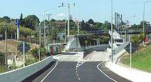
Major related structures are the new Esmonde Interchange (including large-scale improvements for general traffic) and Tristram Avenue Viaduct, which crosses the often-congested Tristram Avenue via grade separation. The viaduct has 12 spans of 30 m each, with the foundation piles being 1.5 m thick.[19]
Electricity transmission cables
Cable ducts were placed beneath the busway during the construction in 2005, to provide for the future installation of electricity transmission cables. The cables installed in these ducts during 2012 and 2013 form part of a major upgrade to the security of supply to North Auckland and Northland.[23][24]
Plans
The dedicated busway lanes will be extended northwards from Constellation Station to Albany Station.[25]
An extension towards Orewa in the north is being debated for the long-term future. It was originally expected to cost around NZ$500 million,[17] although the success of the scheme has now sparked potentially more extensive schemes for between NZ$700 million and NZ$1.2 billion to at least Silverdale, with up to five tunnels and seven bridges, including a motorway flyover between Constellation and Albany stations. Plans in 2008 included additional stations at Rosedale and Redvale.[26]
In December 2017, plans were released for a $70 million station at Rosedale, situated between the Albany and Constellation stations. The station would be sited on Arrenway Drive with platforms extending across Rosedale Road for bus transfers to other routes. A construction start date of mid-2019 and opening in 2021 were proposed.[27]
See also
- Other busway systems
- Public transport in Auckland
- Ritchies Transport, contracted operator of NX1 service
- Tranzurban Auckland, contracted operator of NX2 service (formerly 881 route)[28]
- Skybus Super Shuttle, operator of North Harbour Express services between Auckland Airport and Albany
References
- ↑ Rail electrification - Region Wide, Auckland Regional Council newsletter, June 2007, Page 3
- 1 2 Northern Busway Project (PDF) (Map). 1 : 4,000. NZ Transport Agency. Archived from the original (PDF) on 8 October 2007. Retrieved 12 August 2014.
- ↑ North Shore Busways (from the NZ Strong Construction company website. Accessed 2008-03-03.)
- 1 2 3 4 Dedicated busway a roaring success - LG, New Zealand Local Government, March 2008, Volume 44 No 03
- 1 2 3 Busway bits 'n' pieces - Region Wide, newsletter of the Auckland Regional Council, March 2008, Page 4
- ↑ "Multi-million dollar busway opens". Television New Zealand. 2 February 2008. Archived from the original on 16 May 2011. Retrieved 1 November 2011.
- ↑ Northern Busway - The New Zealand Herald, Saturday 30 June 2007, Page C6
- ↑ Busway reduces cars by 500 each rush hour - Region Wide, newsletter of the Auckland Regional Council, March 2008, Page 4
- ↑ "Busway wins excellence award". The New Zealand Herald. 26 August 2008. Retrieved 1 November 2011.
- ↑ "Northern Busway wins award". The New Zealand Herald. 8 June 2009. Retrieved 1 November 2011.
- ↑ "Like a railway, but with buses". Region Wide. Auckland Regional Council. July 2010. p. 2.
- ↑ "Keeping our region moving". Our Auckland. Auckland Council. July 2011.
- ↑ "New Hibiscus Coast bus network revealed by Auckland Transport". Stuff.co.nz. 7 July 2015. Retrieved 23 July 2017.
- ↑ "Plans for rail line through Auckland's North Shore to be determined this year". Stuff.co.nz. 14 March 2017. Retrieved 16 July 2017.
- ↑ "Auckland's Northern Busway to reach capacity a decade ahead of schedule". Stuff.co.nz. 14 September 2017. Retrieved 20 September 2017.
- 1 2 Welcome to the Northern Busway (from the official project website)
- 1 2 Following the money - e.nz magazine, IPENZ January/February 2007
- 1 2 "SH1 Northern Busway". NZ Transport Agency. Retrieved 22 March 2016.
- 1 2 Busway the way of the future for North Shore - LG, New Zealand Local Government, May 2007, Volume 43 No 05
- ↑ "New Skybus North Harbour Airport Service Ready to Go". Scoop Independent News. 8 June 2018. Retrieved 13 September 2018.
- ↑ "On the bus". Auckland Transport. Retrieved 22 March 2016.
- ↑ Frequently Asked Question (from the North Shore City Council website. Accessed 2008-03-21.)
- ↑ "Transpower 220 kV Auckland CBD Cable Ducts Project". Transpower. 18 May 2006. Retrieved 5 April 2012.
- ↑ "$415m cable project to protect power supply". NZ Herald. 21 October 2011. Retrieved 31 March 2012.
- ↑ "Northern Corridor Newsletter - August 2015 21 August 2015" (PDF). New Zealand Transport Agency. 21 August 2015. Retrieved 18 May 2016.
- ↑ Dearnaley, Mathew (13 November 2008). "Buzzing busway could get even bigger". The New Zealand Herald. Retrieved 1 November 2011.
- ↑ "Businesses, students to benefit from new bus station on Auckland's Northern Busway". Stuff.co.nz. 8 December 2017. Retrieved 13 December 2017.
- ↑ "About Us | Tranzurban". Tranzurban. 2018. Retrieved 2 October 2018.
Tranzurban is the newest addition to Tranzit Group and will operate a part of the new North Shore bus network from September 2018 in collaboration with Auckland Transport.
External links
- Northern Busway (official project website - archived version)
| Wikimedia Commons has media related to Northern Busway, Auckland. |