Orakei railway station
Orakei | |||||||||||
|---|---|---|---|---|---|---|---|---|---|---|---|
| Auckland Transport Urban rail | |||||||||||
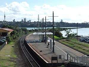 The station in 2013, looking westwards. | |||||||||||
| Location | Orakei, Auckland | ||||||||||
| Coordinates | 36°51′45″S 174°48′34″E / 36.862426°S 174.809553°E | ||||||||||
| Owned by | KiwiRail and Auckland Transport | ||||||||||
| Line(s) | Eastern Line | ||||||||||
| Platforms | Island platform | ||||||||||
| Tracks | Mainline (2) | ||||||||||
| Construction | |||||||||||
| Platform levels | 1 | ||||||||||
| Parking | Yes | ||||||||||
| Bicycle facilities | No | ||||||||||
| History | |||||||||||
| Opened | 1930 | ||||||||||
| Electrified | 25kV AC | ||||||||||
| Traffic | |||||||||||
| Passengers (2011) | 983[1] passengers/weekday | ||||||||||
| Services | |||||||||||
| |||||||||||
Orakei railway station in the Auckland suburb of Orakei is located on the Eastern Line of the Auckland railway network in New Zealand. It has an island platform layout and can be reached by an overbridge from Orakei Road. It is backed by a car-park and a shopping complex.
Overview
The Redwood development group is currently (2008) planning to substantially redevelop the area around the railway station. A plan with several skyscraper-style apartment buildings (and in turn providing substantial green space and waterfront access to the public) met with substantial local protest. A more scaled-back plan was then proposed which limits the buildings to six storeys and is currently being discussed. It would retain public access and amenities, and also provide a covered new train station.[2]
Services
Transdev Auckland, on behalf of Auckland Transport, operates suburban services between Britomart Transport Centre and Manukau station via this station. The basic weekday off-peak timetable is:[3]
- 3 tph to Britomart
- 3 tph to Manukau
Bus route 781 serves Orakei station.[4]
See also
References
- ↑ Auckland Transport Board Meeting (20 November 2012) Agenda Item 10(i) "Rail Electrification Extension" Archived 14 December 2012 at the Wayback Machine. p. 16
- ↑ Borley, Craig (10 October 2008). "Developer scales down Orakei plan". The New Zealand Herald. Retrieved 1 November 2011.
- ↑ "Eastern Line timetable" (PDF). Auckland Transport. Archived from the original (PDF) on 27 January 2016. Retrieved 10 June 2016.
- ↑ "Central Auckland Network Map" (PDF). Auckland Transport. Retrieved 8 July 2018.