Pu'er City
| Pu'er 普洱市 | |
|---|---|
| Prefecture-level city | |
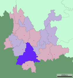 Location of Pu'er City jurisdiction in Yunnan | |
 Pu'er Location of the city centre in Yunnan | |
| Coordinates: 22°47′N 100°58′E / 22.783°N 100.967°ECoordinates: 22°47′N 100°58′E / 22.783°N 100.967°E | |
| Country | People's Republic of China |
| Province | Yunnan |
| GB/T 2260 CODE | 530800 |
| Admin HQ | Simao District |
| Admin units | |
| Area | |
| • Total | 45,385 km2 (17,523 sq mi) |
| Elevation[1] | 1,306 m (4,285 ft) |
| Highest elevation | 3,306 m (10,846 ft) |
| Lowest elevation | 376 m (1,234 ft) |
| Population | |
| • Total | 2,360,000 |
| • Density | 52/km2 (130/sq mi) |
| Time zone | UTC+8 (China Standard Time) |
| Postal code | 665000 |
| Area code(s) | 0879 |
| ISO 3166 code | CN-YN-08 |
| Licence plate prefixes | 云J |
| Website |
www |
| Yunnan Statistics Bureau[2] Yunnan Portal[3] | |
| Pu'er City | |||||||
| Chinese | 普洱 | ||||||
|---|---|---|---|---|---|---|---|
| Postal | Puerh | ||||||
| |||||||
| Alternative Chinese name | |||||||
| Chinese | 思茅 (1950–2007) | ||||||
| Postal | Szumao (1950–2007) | ||||||
| |||||||
Pu'er is a prefecture-level city in southern Yunnan Province, China. The name Pu'er dates back to 1729, but was changed to Simao in 1950 after the Communist Revolution. In 2007, the original name of Pu'er was restored. This change had an effect on the size of the official Pu'er tea production area, a major regional product. The urban administrative center of Pu'er is Simao District, which is also the former name of the prefecture-level city itself. A major downturn in the price of tea in 2007 caused severe economic distress in the area.[4] The price of Pu'er has since recovered and Pu'er tea still contributes much to the income of the area.
Geography and climate
Pu'er is located in southern/southwestern Yunnan, on the lower reaches of the Mekong (known in Chinese as the Lancang), with the bordering prefectures being Yuxi to the northeast, Honghe to the east, Xishuangbanna to the south, Lincang to the northwest, and Dali and Chuxiong. It also shares borders with Vietnam (Điện Biên Province), Laos (Phongsaly Province), and Burma (Shan State), being the only prefecture in Yunnan to border all three countries. As with much of the province, mountainous terrain dominates its administrative area, covering 98.3%. Elevations range from 376 to 3,306 metres (1,234 to 10,846 ft).[1]
Located at an altitude of above 1,300 m (4,300 ft) and within a degree south of the Tropic of Cancer, Pu'er, as with much of southern Yunnan, has a warm humid subtropical climate (Köppen Cwa), with muddled distinction between the seasons and daytime temperatures remaining warm year-round. Highs peak in April and May before the core of the rainy season and reach a minimum in December; however, the warmest and coolest months are June and January, respectively at 22.7 °C (72.9 °F) and 13.4 °C (56.1 °F); the annual mean is 18.93 °C (66.1 °F). June through September accounts for nearly 70% of the annual rainfall of 1,487.4 mm (59 in) and during this time, some rainfall occurs on most days, pushing relative humidity above 80% and there is a marked reduction in sunshine. With monthly percent possible sunshine ranging from 24% in July to 69% in February, the city receives 2,038 hours of bright sunshine annually.
| Climate data for Pu'er (1981−2010) | |||||||||||||
|---|---|---|---|---|---|---|---|---|---|---|---|---|---|
| Month | Jan | Feb | Mar | Apr | May | Jun | Jul | Aug | Sep | Oct | Nov | Dec | Year |
| Record high °C (°F) | 27.6 (81.7) |
29.8 (85.6) |
32.0 (89.6) |
33.4 (92.1) |
34.7 (94.5) |
33.5 (92.3) |
31.8 (89.2) |
32.3 (90.1) |
31.0 (87.8) |
29.6 (85.3) |
27.3 (81.1) |
25.5 (77.9) |
34.7 (94.5) |
| Average high °C (°F) | 21.1 (70) |
23.4 (74.1) |
26.4 (79.5) |
28.5 (83.3) |
28.0 (82.4) |
27.5 (81.5) |
26.5 (79.7) |
27.0 (80.6) |
26.3 (79.3) |
24.8 (76.6) |
22.4 (72.3) |
20.4 (68.7) |
25.2 (77.3) |
| Daily mean °C (°F) | 13.4 (56.1) |
15.1 (59.2) |
18.1 (64.6) |
20.8 (69.4) |
21.9 (71.4) |
22.7 (72.9) |
22.1 (71.8) |
22.2 (72) |
21.3 (70.3) |
19.7 (67.5) |
16.4 (61.5) |
13.5 (56.3) |
18.9 (66.1) |
| Average low °C (°F) | 8.1 (46.6) |
8.9 (48) |
11.5 (52.7) |
14.8 (58.6) |
17.7 (63.9) |
19.8 (67.6) |
19.8 (67.6) |
19.6 (67.3) |
18.5 (65.3) |
16.7 (62.1) |
12.6 (54.7) |
9.3 (48.7) |
14.8 (58.6) |
| Record low °C (°F) | 2.0 (35.6) |
3.4 (38.1) |
0.8 (33.4) |
8.3 (46.9) |
11.4 (52.5) |
14.5 (58.1) |
16.4 (61.5) |
15.1 (59.2) |
12.1 (53.8) |
8.1 (46.6) |
4.7 (40.5) |
−0.3 (31.5) |
−0.3 (31.5) |
| Average precipitation mm (inches) | 13.9 (0.547) |
18.1 (0.713) |
24.0 (0.945) |
52.3 (2.059) |
154.3 (6.075) |
211.3 (8.319) |
330.8 (13.024) |
290.2 (11.425) |
179.5 (7.067) |
120.9 (4.76) |
70.4 (2.772) |
21.7 (0.854) |
1,487.4 (58.56) |
| Average relative humidity (%) | 76 | 68 | 62 | 65 | 74 | 82 | 86 | 85 | 83 | 82 | 81 | 80 | 77 |
| Source: China Meteorological Data Service Center | |||||||||||||
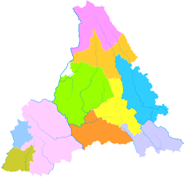
Administrative divisions
| Map | |||||
|---|---|---|---|---|---|
| Name | Hanzi | Hanyu Pinyin | Population (2003 est.) |
Area (km²) | Density (/km²) |
| Simao District | 思茅区 | Sīmáo Qū | 200,000 | 4,093 | 49 |
| Ning'er Hani and Yi Autonomous County | 宁洱哈尼族彝族自治县 | Níng'ěr Hānízú Yízú Zìzhìxiàn | 190,000 | 3,670 | 52 |
| Mojiang Hani Autonomous County | 墨江哈尼族自治县 | Mòjiāng Hānízú Zìzhìxiàn | 350,000 | 5,459 | 64 |
| Jingdong Yi Autonomous County | 景东彝族自治县 | Jǐngdōng Yízú Zìzhìxiàn | 350,000 | 4,532 | 77 |
| Jinggu Dai and Yi Autonomous County | 景谷傣族彝族自治县 | Jǐnggǔ Dǎizú Yízú Zìzhìxiàn | 290,000 | 7,777 | 37 |
| Zhenyuan Yi, Hani and Lahu Autonomous County | 镇沅彝族哈尼族拉祜族自治县 | Zhènyuán Yízú Hānízú Lāhùzú Zìzhìxiàn | 200,000 | 4,223 | 47 |
| Jiangcheng Hani and Yi Autonomous County | 江城哈尼族彝族自治县 | Jiāngchéng Hānízú Yízú Zìzhìxiàn | 90,000 | 3,476 | 26 |
| Menglian Dai, Lahu and Va Autonomous County | 孟连傣族拉祜族佤族自治县 | Mènglián Dǎizú Lāhùzú Wǎzú Zìzhìxiàn | 110,000 | 1,957 | 56 |
| Lancang Lahu Autonomous County | 澜沧拉祜族自治县 | Láncāng Lāhùzú Zìzhìxiàn | 470,000 | 8,807 | 53 |
| Ximeng Va Autonomous County | 西盟佤族自治县 | Xīméng Wǎzú Zìzhìxiàn | 80,000 | 1,391 | 58 |
Sports
Association football is the most popular sport in Pu'er. The largest sports venue in the city is the 15,000-capacity Pu'er Stadium.
Transport
References
- 1 2 普洱城市介绍以及其后背景分析——中国天气网 最好最全面天气预报信息资讯平台 (in Chinese). Weather China. Retrieved 2012-06-30.
- ↑ 云南省统计局. yn.gov.cn (in Chinese).
- ↑ 云南省人民政府门户网站. Yunnan People's Government (in Chinese).
- ↑ Jacobs, Andrew. "A County in China sees Its Fortune in Tea Leaves until a Bubble Bursts, International Herald Tribune, January 17, 2009". New York Times.
External links
| Wikimedia Commons has media related to Pu'er City. |
Yunnan topics | |
|---|---|
| General | |
| Geography | |
| Education | |
| Culture | |
| Cuisine |
|
| Visitor attractions | |
| |