Porto Torres
| Porto Torres Posthudorra | |
|---|---|
| Comune | |
| Comune di Porto Torres | |
.jpg) | |
 Porto Torres Location of Porto Torres in Sardinia | |
| Coordinates: 40°50′N 8°24′E / 40.833°N 8.400°E | |
| Country | Italy |
| Region | Sardinia |
| Province | Sassari (SS) |
| Government | |
| • Mayor | Sean Christian Wheeler |
| Area | |
| • Total | 102.62 km2 (39.62 sq mi) |
| Population (30 November 2017)[1] | |
| • Total | 22,335 |
| • Density | 220/km2 (560/sq mi) |
| Demonym(s) | Turritani or Portotorresi |
| Time zone | UTC+1 (CET) |
| • Summer (DST) | UTC+2 (CEST) |
| Postal code | 07046 |
| Dialing code | 079 |
| Patron saint | St. Gavinus |
| Saint day | 30 May |
| Website | Official website |
Porto Torres (Sassarese: Posthudorra, Sardinian: Pòrtu Turre) is a comune and city in the Province of Sassari, northern Sardinia, Italy.
It is situated on the north-west coast about 25 kilometres (16 mi) east of the Gorditanian promontory (Capo del Falcone), and on the spacious bay of the Gulf of Asinara.
Geography
Porto Torres' territory is situated on the north-west part of Sardinian Coast.
The extension of municipality is almost 10200 hectare and is subdivided in two parts, with almost the same extension. One part includes the city, the industrial area and the Roman ruins; the latter is formed by the Asinara island with the smaller Isola Piana. This part of territory is, since 1997, a national park.
The morphology of "city part" is flat; the area of Porto Torres and the rest part of north-west Sardinia is characterized by a Nurra flat, there are some hill formation in the middle of the flat. Part of this hill formation is in Porto Torres' territory and the highest elevation of it is Monte Alvaro with it thickness of 342 m.
The communal territory is crossed by two rivers, Rio Mannu and Fiume Santo. The first draws the edge of Porto Torres territory on west, while instead the latter flows near the city and was used as a fluvial way as early as the Roman age.
History
.jpg)
In ancient times, Turris Libyssonis was one of the most considerable cities in Sardinia. It was probably of purely Roman origin, founded apparently by Julius Caesar, as it bore the title Colonia Julia.[2] Pliny described it as a colony, the only on the island in his time, suggesting that there was previously no town on the spot, but merely a fort or castellum.[3] It is noticed also by Ptolemy and in the Itineraries, but without any indication that it was a place of any importance.[4]
The ancient remains still existing prove that it must have been a considerable town under the Roman Empire. According to inscriptions on ancient milestones, the principal road through the island ran directly from Caralis (Cagliari) to Turris, a sufficient proof that the latter was a place much frequented. Indeed, two roads, which diverged at Othoca (modern Santa Giusta) connected Caralis to Turris, the more important keeping inland and the other following the west coast. It was also an episcopal see during the early part of the Middle Ages.
The existing port at Porto Torres, which is almost wholly artificial, is based in great part on Roman foundations; and there exist also the remains of a temple (which, as we learn from an inscription, was dedicated to Fortune, and restored in the reign of Philip), of thermae, of a basilica and an aqueduct, as well as a bridge over the adjoining small river, still called the Fiume Turritano. The ancient city continued to be inhabited till the 11th century, when the greater part of the population migrated to Sassari, about 15 kilometres (9 mi) inland, and situated on a hill.[5] It was partly under Genoese hands before, in the early 15th century, it was conquered by the Aragonese. After the Spanish rule it was part of the Kingdom of Sardinia.
Torres was separated from the comune of Sassari in 1842. At the time the area which had been built around the basilica of San Gavino joined the fishermen's community near the port to form the new Porto Torres.
Main sights
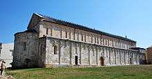
- The 11th-century Basilica of San Gavino, built using only hardstones like marble, porphyry and granite, is the largest Romanesque church in Sardinia. Instead of the usual western facade and eastern apse, the cathedral sports two apses. The crypt holds several Roman sarcophagi.
- Neolithic necropolis of Su Crucifissu Mannu and Li Lioni.
- Nuraghe of la Camusina, Li Pedriazzi, Margone and Minciaredda.
- Remains of the Roman bridge, the largest in Sardinia with its arches and a span of 160 to 170 metres (520 to 560 ft) on the Rio Mannu
- Palazzo Re Barbaro
- Catacombs of Tanca Borgona and piazzale Amsicora.
- Aragonese Towers of the port and of Abbacurrente.
Transportation and industry
The port is connected by ferries with Genoa, Marseille, Toulon, Barcelona, Civitavecchia. Highway SS131/E25 to Sassari and Cagliari, and a national road to Santa Teresa Gallura (SS200). A railway operated by Trenitalia connects the town with Sassari, and the rest of the island.
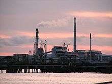
Chemical industries support the modern economy of Porto Torres. Fiume Santo, a 1,040 MW power station owned by E.ON, is 5 to 10 kilometres (3 to 6 mi) west from the port, in the municipality of Sassari.[6]
Plans related to industrial conversion are in progress in Porto Torres, where seven research centres are developing the transformation from traditional fossil fuel related industry to an integrated production chain from vegetable oil using oleaginous seeds to bio-plastics.[7][8]
References
- ↑ All demographics and other statistics: Italian statistical institute Istat.
- ↑

- ↑ Smith 1857, p. 1241 Cites: Plin. iii. 12. s. 17.
- ↑ Smith 1857, p. 1241 Cites: Ptol. iii. 3. § 5; Itin. Ant. p. 83.
- ↑ Smith 1857, p. 1241 Cites: De la Marmora, Voy. en Sardaigne, vol. ii. pp. 363,468-72; Smyth's Sardinia, pp. 263-66.
- ↑ "Fiume Santo Power Station (Thermoelectric Power Plant), Italy". Retrieved 28 January 2011.
- ↑ matrica: green chemicals
- ↑ A new age for the Italian chemical industry
Sources
| Wikimedia Commons has media related to Porto Torres. |

| Authority control |
|---|