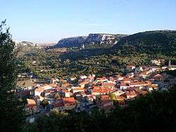
Cargeghe
| Cargeghe Carzèghe | ||
|---|---|---|
| Comune | ||
| Comune di Cargeghe | ||
 | ||
| ||
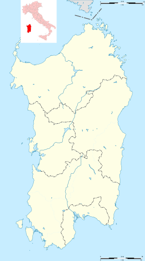 Cargeghe Location of Cargeghe in Sardinia | ||
| Coordinates: 40°40′N 8°37′E / 40.667°N 8.617°E | ||
| Country | Italy | |
| Region | Sardinia | |
| Province | Sassari (SS) | |
| Government | ||
| • Mayor | Franco Spada | |
| Area | ||
| • Total | 12.05 km2 (4.65 sq mi) | |
| Elevation | 333 m (1,093 ft) | |
| Population (31 May 2017[1]) | ||
| • Total | 714 | |
| • Density | 59/km2 (150/sq mi) | |
| Demonym(s) | Cargeghesi | |
| Time zone | UTC+1 (CET) | |
| • Summer (DST) | UTC+2 (CEST) | |
| Postal code | 07030 | |
| Dialing code | 079 | |
| Website | Official website | |
Cargeghe (Sardinian: Carzèghe) is a comune (municipality) in the Province of Sassari in the Italian region Sardinia, located about 170 kilometres (110 mi) north of Cagliari and about 9 kilometres (6 mi) southeast of Sassari.
Cargeghe borders the following municipalities: Codrongianos, Florinas, Muros, Osilo, Ossi.
Sights include the necropolis of S'Elighe Entosu, including a series of domus de janas (Neolithic tombs), the parish church (15th-16th centuries) and the countryside Romanesque church of Santa Maria 'e Contra (12th century).
References
| Wikimedia Commons has media related to Cargeghe. |


This article is issued from
Wikipedia.
The text is licensed under Creative Commons - Attribution - Sharealike.
Additional terms may apply for the media files.