San Teodoro, Sardinia
| San Teodoro Santu Diadoru | |
|---|---|
| Comune | |
| Comune di San Teodoro | |
 San Teodoro Location of San Teodoro in Sardinia | |
| Coordinates: 40°46′N 9°40′E / 40.767°N 9.667°ECoordinates: 40°46′N 9°40′E / 40.767°N 9.667°E | |
| Country | Italy |
| Region | Sardinia |
| Province | Sassari (SS) |
| Frazioni | La Suarédda, Monti Pitrosu, Stràula, Budditogliu, La Traversa, Lu Fraili, Lu Sitagliacciu, Lu Lioni, L'Alzoni, Lu Ricciu, Narachéddu, Tiridduli, Schiffoni, Franculacciu, Stazzu Brusgiatu |
| Area | |
| • Total | 104.8 km2 (40.5 sq mi) |
| Population (Dec. 2004) | |
| • Total | 3,565 |
| • Density | 34/km2 (88/sq mi) |
| Demonym(s) | Teodorini |
| Time zone | UTC+1 (CET) |
| • Summer (DST) | UTC+2 (CEST) |
| Postal code | 08020 or 07052 |
| Dialing code | 0784 |
| Website | Official website |
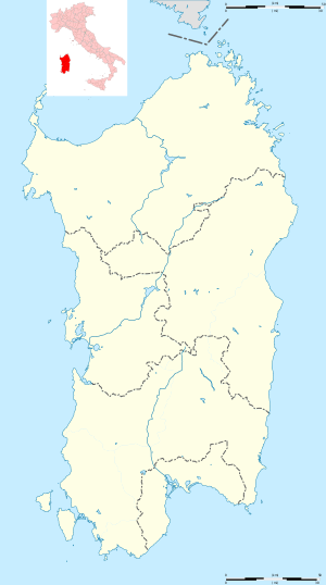
San Teodoro (Gallurese: Santu Diadòru, Sardinian: Santu Tiadòru) is a comune (municipality) in the Province of Sassari in the Italian region Sardinia, located about 180 kilometres (110 mi) northeast of Cagliari and about 20 kilometres (12 mi) southeast of Olbia. As of 31 December 2004, it had a population of 3,565 and an area of 104.8 square kilometres (40.5 sq mi).[1]
The municipality of San Teodoro contains several frazioni (subdivisions, mainly villages and hamlets), among which: La Suarédda, Monti Pitrosu, Straula, Budditogliu, La Traversa, Lu Fraili, and Lu Sitagliacciu.
San Teodoro borders the following municipalities: Budoni, Loiri Porto San Paolo, Padru, Torpè.
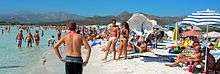
The beach of "La Cinta" was home of the kite boarding festival in September 2010.
The beach of "Lu Impostu" is also known as Little Thaiti due to the beautiful colours of the sea.
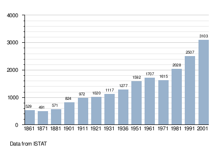
Demographic evolution
References
External links
| Wikimedia Commons has media related to San Teodoro, Sardinia (Italy). |