Port Vincent, South Australia
| Port Vincent South Australia | |||||||||||||||
|---|---|---|---|---|---|---|---|---|---|---|---|---|---|---|---|
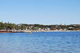 Looking towards the beach at Port Vincent | |||||||||||||||
 Port Vincent | |||||||||||||||
| Coordinates | 34°46′0″S 137°51′0″E / 34.76667°S 137.85000°ECoordinates: 34°46′0″S 137°51′0″E / 34.76667°S 137.85000°E | ||||||||||||||
| Population | 472 (2006 census)[1] | ||||||||||||||
| Established | 1877 | ||||||||||||||
| Postcode(s) | 5581 | ||||||||||||||
| Elevation | 5 m (16 ft) | ||||||||||||||
| Location | 194 km (121 mi) from Adelaide | ||||||||||||||
| LGA(s) | Yorke Peninsula Council | ||||||||||||||
| State electorate(s) | Narungga[2] | ||||||||||||||
| Federal Division(s) | Grey[3] | ||||||||||||||
| |||||||||||||||
| Footnotes | Adjoining localities[4] | ||||||||||||||
Port Vincent is a small town on the east coast of Yorke Peninsula in South Australia, 194 km from Adelaide by road. At the 2006 census, Port Vincent had a population of 472.[1]
History
The Narungga Aborigines inhabited the area prior to white settlement. The town was laid out by Adelaide solicitor L.M. Cullen in 1877, originally known as Surveyor's Point.
In its early days it was a port exporting wheat, barley, wool and mallee stumps (firewood). From the first settlement in 1852 until 1877, coastal trading ketches would beach at high tide, and unload directly to farm wagons at low tide. A jetty was built into the bay in 1877, construction of a wharf began in 1901, and the original jetty was removed in 1918. Port Vincent was the main entry point for people and goods to and from the Yorke Peninsula until a good road was built from Port Wakefield in around 1949. Three major fuel companies had storage and distribution depots in the town, supplied by boat or barge from Port Adelaide.[5]
The town today
A seaside holiday destination for many years, recently it has been the site of a marina development. Port Vincent was named Australia's Tidiest Town in 2004, having won the South Australian award in 2000 and 2003.[6] It has active volunteer organisations including the CFS, Coast Guard, Tidy Towns etc.
In 2003/04 a large marina was constructed in Port Vincent. It is operated by the Cruising Yacht Club of South Australia.[7] Port Vincent can also cater for schools on camp. The town has grown in size over the last few years with the release of land for housing. There is a proposed 'next stage', which will include over 100 domestic building blocks and possibly a retirement village.
2011 saw Port Vincent win the State's Cleanest Beach Award and went on to the National Judging.[8]
VAC swim operates there in the summer holidays.[9]
See also
Notes and references
- 1 2 Australian Bureau of Statistics (25 October 2007). "Port Vincent (L) (Urban Centre/Locality)". 2006 Census QuickStats. Retrieved 23 October 2011.
- ↑ Narungga (Map). Electoral District Boundaries Commission. 2016. Retrieved 1 March 2018.
- ↑ "Federal electoral division of Grey" (PDF). Australian Electoral Commission. Retrieved 24 July 2015.
- ↑ "New Ward Structure 2014". Yorke Peninsula Council. Archived from the original on 15 January 2016. Retrieved 21 October 2015.
- ↑ "Port Vincent". This is Australia. Retrieved 29 September 2014.
- ↑ "Australian Tidy Towns Honour Roll". Keep Australia Beautiful. Retrieved 29 September 2014.
- ↑ "Marina Port Vincent". Cruising Yacht Club of South Australia. Retrieved 8 April 2018.
- ↑ "Australian Clean Beaches Honour Roll". Keep Australia Beautiful. Retrieved 29 September 2014.
- ↑ "Port Vincent Beach". VACSWIM locations. SA WAter VACSWIM. Retrieved 8 April 2018.
External links
| Wikimedia Commons has media related to Port Vincent, South Australia. |
| Major Townships | |||||||
|---|---|---|---|---|---|---|---|
| Minor Townships | |||||||
| Governance |
| ||||||
| Coastal features | |||||||
| Protected areas |
| ||||||
| Adjacent islands | |||||||
| Related and uncategorised | |||||||
| |||||||