Ponta Grossa
| Ponta Grossa, Paraná | |||
|---|---|---|---|
| City | |||
| |||
|
Nickname(s): Princesa dos Campos Capital Cívica do Paraná | |||
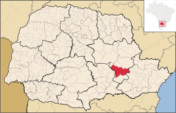 Location of Ponta Grossa | |||
 Ponta Grossa Location in Brazil | |||
| Coordinates: 25°25′S 49°15′W / 25.417°S 49.250°W | |||
| Country |
| ||
| Region | South | ||
| State |
| ||
| Historic countries |
| ||
| Settled (town) | September 15, 1823 | ||
| Incorporated (city) | March 24, 1862 | ||
| Government | |||
| • Type | City hall | ||
| • Mayor | Marcelo Rangel (PSDB) | ||
| • Council | Ponta Grossa City Council | ||
| Area | |||
| • City | 2,067.6 km2 (798.65 sq mi) | ||
| • Urban | 172.41 km2 (6,658,72 sq mi) | ||
| Elevation | 975 m (3,199 ft) | ||
| Population (2010)[1] | |||
| • City | 311,611 | ||
| • Estimate (2018)[2] | 348,043 | ||
| • Rank |
77th, Brazil 4th, Paraná | ||
| • Density | 150.55/km2 (388/sq mi) | ||
| • Urban | 304,733[3] | ||
| • Metro | 430,075[4] | ||
| population of the Microregion of Ponta Grossa which covers four towns | |||
| Demonym(s) |
pontagrossense princesino | ||
| GDP | |||
| • Year | 2015 estimate | ||
| • Total | R$11,805,538.69 thousands (7th, Paraná) | ||
| • Per capita | R$34,941.59 (63rd, Paraná) | ||
| HDI | |||
| • Year | 2010 | ||
| • Category | 0.763 very high (19th), Paraná) | ||
| Time zone | UTC-3 (BRT) | ||
| • Summer (DST) | UTC-2 (BRST) | ||
| Postalcode (CEP) | 84010-000 | ||
| Area codes | +55 42 | ||
| State Highways | PR-151 and PR-513 | ||
| Federal Highway | BR-376 | ||
| Municipality Code | 4119905 | ||
| Website |
pontagrossa.pr.gov.br (in Portuguese) | ||


Ponta Grossa (Portuguese pronunciation: [po'tɐ ˈɡɾo.sɐ]) is a municipality in the state of Paraná, southern Brazil. The estimated population for 2018 is 348,043, according to official data from the institute in charge in the country[2], it is the 4th most populous city in Paraná (77th in the Brazil). It is too the largest city in the state around Greater Curitiba, within a radius of 186 miles (300 km). It is known as Princesa dos Campos (in English: Princess of the Fields) and Capital Cívica do Paraná (in English: Civic Capital of Paraná) . Its settlement is connected to the Caminho das Tropas (in English: Path of the Troops), being one of the points of landing of tropeiros in the middle of a high hill inside a grassy vegetation.[5] The city is considered of average size appearing of a central hill[6], its most accelerated growth occurred in the second half of the twentieth century with the weakening of the primary economy.[7]
Ponta Grossa has one of the largest tourist destinations in the state especially in the area of natural beauty, Vila Velha State Park is located within the limits of the municipality.[8] The cup of Vila Velha refers to its location in the collective imagination.[9] Other important activities are the important agricultural sector as the basis for the supply of commodities for local agroindustry. München Fest, party dedicated to German culture, also known as the Festa Nacional do Chopp Escuro (in English: Dark Chopp National Party), is the biggest event in Paraná that usually lasts a week between November and December.[10]
In this city, the industrial sector is fundamental. It is the largest industrial pole in the interior of Paraná, aided by the recent intense industrialization (since 2013 the minimum was 40 new industries). The agroindustry, the lumber and metalworking sector are the main types of factories found.[11] The result is reflected in GDP, in the interior being below only Foz do Iguaçu, for which it can still be exceeded. [12]
Etymology
The place where it is located has a toponymia related to a hill seen long distance during trips to the Campos Gerais.[13] The name would have originated a high hill that stood out before the whole pastures landscape by its prominent height and the capo of bush that covers it. The tropeiros to refer to its located said that they were near Ponta Grossa. But other stories have the same idea, like that of the foreman when he tells the farmer the place chosen to establish his farm, "there at Ponta Grossa". Or even that the name had seen later when the owner ceded the lands for settlement.[5]
Ponta Grossa would have been built on the farm of Miguel da Rocha Ferreira Carvalhaes who chose it as favorable agricultural land. The farm still exists towards Castro. [13] In 1871 the city came to be called Pitangui, but the following year it resumed its original nomenclature. Sometimes it is the target of malicious humor due to what its name can send in Portuguese.[14] One way or another describes the characteristics of the vegetation and the regional topography.[15]
History
The history usually accepted according to the historian Paulo Eduardo Dias de Mello are of the tropeiros who passed with their muares towards the fair of Sorocaba. Ponta Grossa served as a resting point since 1703 of the long voyages that left Rio Grande do Sul. Along the way was commercialized the charque, where the meat was preserved only with salt. Unlike other settlements, Ponta Grossa was not inhabited, indigenous groups occupied places to the north, with expansion, conflicts later came with European settlers, such as that of the city of Reserva, but outside the urban space of the city in question. Another version, but not necessarily contradictory, states that the farmers of the area would launch a couple of pigeons and where these birds would land would mark the beginning of the Freguesia with the construction of the chapel Mrs. Saint Anne.[16]
Colonial Expeditions
Ponta Grossa had its territory traversed from the XVI century, when the Campos Gerais were crossed by Spanish expeditions that demanded of the Santa Catarina coast until Asunción, in Paraguay. Later it was successively moved on account of the seiscentistas bandeirantes, notably for capture of the natives.[17] Portuguese bandeirantes like Aleixo Garcia passed in 1525, five years later Peró Lobo and Francisco Chaves. In 1541 passed the Spaniard Álvar Nuñez Cabeza de Vaca who had some conflicts of tribes not too distant. Also it is reported the passage of a non-Iberian: Ulrich Schmidel that during the course brought 20 Paraguayan natives and four German soldiers from the current paulista coast.[18]
Tropeiros, troop drivers (usually mules and donkeys) carrying goods used the region as a route[19], the landscape in the form of a field became welcome to pass with mules and in the future cattle ranching. The fixation in the form of farms by the tropeiros came beyond the rest, like treatment and fattening of the animals or they were located there because occasional events of flood of the next rivers.[20] Preferably, the tropeiros chose to settle near the banks of the Verde and Pitangui River.[18] In order to meet these people, trade began to emerge, unleashing the forms of villages and freguesias, as in the case of Ponta Grossa and other cities in the region.[20] But the actual possession of the land, for purposes of occupation and colonization, which resulted in the founding of the city of Ponta Grossa, took place from 1800, when the Campos Gerais were under the jurisdiction of Vila Nova de Castro.[17]
The first settlers who settled here were farmers from the state of São Paulo, especially due to the abundance of natural pastures and the beauty of the Campos Gerais. They settled in the environs of the rivers Verde and Pitangui, throwing the seeds of settlement of the place. Shortly after Benedictines of the Monastery of the Saints obtained grant of these fields, that called Santa Bárbara Farm. However, in 1813, the interim governor of the Province of São Paulo, D. Matheus Abreu Pereira, donated these same lands to the lieutenant Atanagildo Pinto Martins, a bandeirante from Paraná who perlustrated the way of the Fields of Palms. The Benedictines protested, claiming acquired rights, presenting the Term of Concession, but nothing of value was worth the appeals, finishing the immense areain possession of bandeirante Atanagildo.[17]
Fixed Settlements
It was not long before, and he was lord of the Campos Gerais, the Captain-General José Góes e Moraes. Along with Pedro Taques de Almeida (besides others of noble lineage) that required territories between the left bank of the Itarare River and the headwaters of the Tibagi River[20], they donated part of his lands to the Jesuits who in the vicinity of São Miguel Riverside, a tributary of the Pitangui River, erected the Santa Bárbara do Pitangui Chapel. where they established the Curato of the Company of Jesus that in no time knew extraordinary progress.[17] But the route of the main road was diverted, causing a stagnation of the growth of the city where the first built chapel[18]. At the same time, the fields were systematically occupied, with the emergence of large cattle ranches. In this period stands out the Bom Sucesso Farm, the sergeant-major Miguel da Rocha Ferreira Carvalhães, whose limit covered area that today constitutes the urban perimeter of Ponta Grossa.[17] Until 1750 before the Treaty of Madrid was signed, Ponta Grossa belonged to the Spanish Empire.[21] The Santa Bárbara chapel, constructed by Jesuit reductions to the control of the Spanish government was used by oratory by the tropeiros and travelers of Campos Gerais from 1727 by donation of sesmaria of Itaiacoca or the Pitangui. With the abolition of slavery, what did not continue with the catechization and slavery, even with religious groups that came later. Not far from the farm, in the 1970s human bones were found possibly from the slaves of the time.[22]
Where today is the Metropolitan Cathedral, there was a ranch of inn, erected by tropeiros, next to a centenary fig tree, under which they planted a cross. It was there the point of stop of troops and travelers. Another point of reference at this time was the Casa de Telhas (in English: House of Tiles), constructed by the Jesuits for relate with people of the region. In this house were celebrated the offices of the sacrament and religious festivals. In a short time, around the Casa de Telhas appeared the first huts.[17] In addition to serving as Church to hold celebrations was a place of rest. It is believed that the construction of the same was an attempt to press the elevation of Ponta Grossa, until then a neighborhood of Castro to a freguesia. A cemetery and a chapel had also been built. It is he historic moment than the version of the pigeons appears for the choice of place due to divergence between the farmers[18], described in the sequence.
Farmer Miguel da Rocha Ferreira Carvalhães, anticipating the future of the place, sought to encourage his progress. Domingos Teixeira Lobo, Antonio da Rocha Carvalhães and Benedito Mariano Fernandes Ribas, and the need to establish a settlement, since they would solve the difficulties of ecclesiastical matters and civil litigation, since they were jurisdiction to Vila Nova de Castro. It is reported that Carvalhães would have ordered his foreman, Francisco Mulato, to look for a suitable place in the Boa Vista winter estate to start a new settlement. The place chosen would have been the current suburb of Boa Vista. When fulfilling the mission Francisco Mulato would have said "Sinhô knows well because it is leaning in that capon that has the thick tip".[17]
Having approved the name but not the location, the group of farmers decided that the place of the future settlement would be where a white pigeon with a red ribbon bow on the neck, loose in the prairies, would stay overnight. After many flocks, the bird landed exactly on the cross of the ranch of the tropeiros , under the centenary fig tree. existing there, having been interpreted as a good omen and predestination, for the effective settlement of Ponta Grossa.[17] A chapel was built with the help of the inhabitants there, being here the central focus of growth of the old village. Being presented as one of the versions of history, historians do not have proof that this was exactly the origin of the settlement. Even so, the dove is used as a symbol by the municipal government appearing in the anthem, the flag, the coat of arms and the march.[13] Some sources give the name Estrela, as primitive denomination of Ponta Grossa, "because it could be seen of some leagues of distance, situated in the middle of the fields, on an eminence as the present city is still" (Land of the Future - Nestor Victor).[17]
Consolidation
Ponta Grossa seen as a city and with predominantly urban features appeared after 1800. Period that served as a zone of attraction, political discussions begin to arise and even new farms. Until then it was an entirely agrarian environment, where self-sufficiency prevailed through cultivars. Regulatory measures and organs of justice are put into operation as a control of civility. Criatório (where the cattle are handled) and invernagem (rest period of animals) stimulated trade. So that the farmer "returns" to becomes tropeiro again. Through the agriculture do not effective and as consequence the urbanization process is slow.[20]
From then the town progressed extraordinarily. On September 15, 1823, through the Imperial license, the Freguesia of Estrela was created, being first vicar of the locality the father Joaquim Pereira da Fonseca. In 1840 the patrimony was increased, by area denominated Rincão of the Round and donated by Domingos Ferreira Pinto. By the Provincial Law nº 34, of April 7, 1855, was created the municipality of Ponta Grossa, with territory dismembered of the municipality of Castro, being duly installed on December 6 of the same year. The Provincial Law nº 82, of March 24, 1862, elevated the town to the category of city. On April 15, 1871, through Law 281, was renamed Pitangui, but was renamed Ponta Grossa from April 5, 1872, by Provincial Law 409. Ponta Grossa passed the seat of Comarca on April 18, 1876, by Law No. 469, and was installed on December 16 of it, assuming on this date as the first Judge Conrado Ericksen.[17]
In 1878, at the initiative of Augusto Ribas, the Russian-German colonization began in the municipality[23], two years after the visit of the Emperor Dom Pedro II, main incentive of the immigrations, when he stayed in the residence of Major Domingos Pereira Pinto to whom granted the title of Baron of Guaraúna.[24] The state government also encouraged through the figure of Lamenha Lins. By the middle of the nineteenth century, altogether 2,300 Russians-Germans arrived in the region at a time when the city underwent an economic improvement due to the railroad which by the end leveraged the arrival of Slavs, Italians and some people of the Middle East received by the emperor Dom Pedro II.[18]
The city experienced great progress from March 2, 1894, when the Curitiba-Ponta Grossa Railroad was inaugurated[25] (the road facilitated the connection between cities and offered work opportunities[18]), and two years later the construction of the São Paulo-Rio Grande do Sul Railway began. their situation, here have been installed for a long time, the offices and workshops of the railways. Where train maintenance of train. Although some authors consider as something also idealized, the construction of the railroad was important, being Ponta Grossa an entrocamento region. Viewed as city-crossroads due to the construction of highways and roads that gave this geostrategic favoring. The railroad was important for the modernization of the city as well as its growth in the 20th century.[26] From this century onwards with the institution of Brazil Republic, the farmers began to suffer the scarcity of labor, so the main economic source became the yerba mate and wood.[18] In 1904, when Ernesto Guimarães Villela was mayor, the electric lighting system provided by Guimarães' own company Ericksen & Filho was inaugurated and the water and sewage system designed and supervised by engineers Alvaro Souza Martins and Jacob Schamber has implemented it only concluded with funding from the state government by Mayor Teodoro Batista Rosas. The centennial of the foundation was celebrated in the administration of the mayor Brasílio Ribas.[17]
On October 17, 1930, Getúlio Vargas and his troops arrived at the train station, which would remain in the republic for fifteen years.[27] On this occasion Getúlio walked through the city streets alongside Lieutenant-Colonel Galdino Luís Esteves and Aristides Krauser do Canto, being cheered by the popular who waved red handkerchiefs and flags, symbol of the revolution.[17] Until the 1950s, Ponta Grossa was the main city in the interior of the state of Paraná, due to the railways, factories processing the yerba mate, leather and wood processing as well as ceramics workshops, among which the production of bricks. This changed when cities were emerging in the north of the state (for example: Londrina and Maringá) attracted by the coffee economy. Even with the prominence that the cities of the north had been obtaining and other cities that appreciated the construction of highways, the axis Ponta Grossa-Curitiba would have been important in the dynamics of the coffee flow. In addition to banking, administrative and commercialization of manufacturing and primary resources. Although it is also affected when there were economic problems in the cultivation of coffee.[26]
The 1970s marked the beginning of Ponta Grossa the industrial phase linked to the food sector and grain benefiting. In 1990, it expanded its tertiary sector, in addition to receiving logistic and production companies due to its geographic role.[28] Ponta Grossa was the birthplace of great names of Paraná politics, being known as "Civic Capital of Paraná" (in English: Civic Capital of Paraná).[17]
Administrative division
On December 5, 1931 acquires the old municipality of Conchas that happens to be district (Decree nº 2,439). In letters from 1936 and the following year, Itaiacoca appears as another district that on March 31, 1938 was renamed Cerrado (State Decree-Law No. 6,667), returning to the old name on October 20 of the same year (State Decree- Law No. 5773). On December 30, 1943, Conchas became known as Uvaia (State Decree-Law No. 199). On September 11, 1957, the district of Guaragi, an extinct municipality named Entre Rios (State Law No. 3,315), being was incorporated of Palmeira. Piriquitos was the last district to be declared. Created on March 13, 1962 (State Law No. 4,556), leaving it to be a district in the 21st century. Today, in all, they are the previous four, including the headquarters.[29]
Geography
Ponta Grossa is on the Second Plateau Paranaense (also known as Plateau of Ponta Grossa, limited the east through the Escarpa Devoniana), at a latitude of 25º09'S and longitude of 50º16'W, from the capital of Paraná to downtown is 70,8 miles (114 km). The city has 16 neighbourhoods giving the urban area a sum of 172,41 km².[30] The relief is quite bumpy is found numerous valleys within the urban area. [31] It is considered the main road and rail junction in southern Brazil. It has access to the federal highway BR-376 that connects to the north of the state and gives access to BR-277 that allows access from west to east of the state, including Curitiba and Foz do Iguaçu. The same highway gives access in the south direction to resume the BR-376 allowing to go towards Santa Catarina.[32]
The average salary is 2.7 Brazilian minimum wage, placing it in a satisfactory position in Paraná in relation to other areas. The number of people to be in regular employment is 99,317, almost 1/3 of the population, a little more of this proportion represents the amount of workers who receive half of a minimum wage stipulated for the country. The schooling rate is 98.2%. GDP per capita (2015) is R$ 34,941.59. The HDI is 0.763 for 2010. Infant mortality is 11 occurrences for every thousand births, a high value for state statistics. The treatment of sewage is 81.3% in relation to the pipes connected to the network. It is also characterized by low urban afforestation in relation to most of the paranaenses cities.[2] For a historical and phytogeographic regionalization, the city is located in the Campos Gerais do Paraná (In English: General Fields of the Paraná) the most important of the region.[33] For the IBGE's official regionalization, the city is located in the Central-Eastern region of Paraná. Locating in the meso and microregion homonymous to the name of this urban settlement.[34]
Climate
On the Koppen classification is Cfb, typical of the plateaus of southern Brazil which is usually attributed as subtropical of the highlands with mild or warm summers. Although far from the coast has a strong oceanic influence combined with altitude.[35][36] The average annual temperature is 63.5 °F (17.5 °C). Winters are cold to their latitude, but are generally mild to be considered temperate as the true ocean climates. The average temperature in the winter (july) is from 56.7 °F (13.7 °C) and in the summer (january) is from 70.5 °F (21.4 °C), a high temperature average relatively low for the location.[37] In the plant hardiness of the USDA the city is in zone 9b in almost your totality, in the same zone that the Central Florida[38] by which it allows the growth of the genus Pinus, among other subtropical species.[39] The various valleys are important to create microclimates with different temperatures and humidity. Heat islands can occur in the Downtown and Santa Paula (besides the urban density is associated too with the predominant direction of slopes).[40]

According to data from the National Institute of Meteorology (INMET), brazilian institute, referring to the period from 1961 to 1973 (until February 28), the lowest temperature recorded in Ponta Grossa was 21.7 °F (-5.7 °C) on June 9, 1967[41], and the highest reached 94.5 °F (34.7 °C) on November 3, 1968. The largest accumulated precipitation in 24 hours was 5.1' (130.5 mm) on February 13, 1966.[42] Other large accumulations were 4.4' (110.9 mm) on May 6, 1970 and 3.9' (100 mm) on July 4, 1965.[43] The lowest relative humidity was recorded in the afternoon of June 9, 1967, at 14%.[44] Snow is a rare event and there are no historical records of surface accumulation, even if occasional is marked with some passages over a century, the last occurrence was July 23, 2013 starting with a frozen rain.[45] Other years recorded were 1975[46] and 1981[47]. Usually can stay up to 20 years without the occurrence, other times the interval may be 2 years.[48] Frosts are the most common winter event, about 5 annual freezes.[36]
August and July are the driest months due to the cold and dry polar air mass advance. January and February are the most humid due to the humidity that advances from the tropical Atlantic, in addition to the evaporation itself in hot periods generating the short and fast convective rains. However, on average the relative humidity of the air is always high. The number of hours of sunshine does not change much during seasons.[49][31] Tornados and cyclones are rare and there is no history of at least great damage since the beginning of occupation, fortunately. Although there are amateur videos that detected the presence of tornado on December 19, 2010.[50] The fog is a common winter event, which can contribute to the cause of accidents and delayed flights.[51][52][53][54][55]
| Climate data for Ponta Grossa (South of Downtown), elevation: 868.5 m or 2849.4 ft, 1961–1990 normals[lower-alpha 1], extremes for 1961-1973 | |||||||||||||
|---|---|---|---|---|---|---|---|---|---|---|---|---|---|
| Month | Jan | Feb | Mar | Apr | May | Jun | Jul | Aug | Sep | Oct | Nov | Dec | Year |
| Record high °C (°F) | 34.2 (93.6) |
34 (93) |
33.7 (92.7) |
30.6 (87.1) |
30 (86) |
28 (82) |
28.6 (83.5) |
31.4 (88.5) |
32.8 (91) |
33.5 (92.3) |
34.5 (94.1) |
33.9 (93) |
34.5 (94.1) |
| Average high °C (°F) | 28.1 (82.6) |
28.1 (82.6) |
27.2 (81) |
24.5 (76.1) |
22.4 (72.3) |
20.8 (69.4) |
20.8 (69.4) |
22.7 (72.9) |
24.1 (75.4) |
24.6 (76.3) |
26.6 (79.9) |
27.2 (81) |
24.8 (76.6) |
| Daily mean °C (°F) | 21.5 (70.7) |
21.5 (70.7) |
20.5 (68.9) |
17.5 (63.5) |
15 (59) |
13.7 (56.7) |
13.4 (56.1) |
15.1 (59.2) |
17 (63) |
17.9 (64.2) |
19.6 (67.3) |
20.5 (68.9) |
17.8 (64) |
| Average low °C (°F) | 17 (63) |
17.3 (63.1) |
16.1 (61) |
12.9 (55.2) |
9.9 (49.8) |
8.9 (48) |
8.4 (47.1) |
9.8 (49.6) |
12 (54) |
13.4 (56.1) |
14.6 (58.3) |
15.8 (60.4) |
13 (55) |
| Record low °C (°F) | 10.4 (50.7) |
9.2 (48.6) |
6.8 (44.2) |
0.1 (32.2) |
−2.8 (27) |
−5.7 (21.7) |
−4.2 (24.4) |
−3.7 (25.3) |
−1.3 (29.7) |
3.4 (38.1) |
4.6 (40.3) |
6.3 (43.3) |
−5.7 (21.7) |
| Average precipitation mm (inches) | 181.7 (7.154) |
185.2 (7.291) |
148.4 (5.843) |
99.4 (3.913) |
75.9 (2.988) |
124.6 (4.906) |
77.1 (3.035) |
62.8 (2.472) |
123.9 (4.878) |
154.5 (6.083) |
118.5 (4.665) |
164.7 (6.484) |
1,517.1 (59.728) |
| Average precipitation days (≥ 1.0 mm (0.04 in)) | 13 | 12 | 11 | 7 | 5 | 7 | 5 | 6 | 9 | 11 | 9 | 12 | 107 |
| Average snowy days (≥ 0.25 cm (0.1 in)) | 0 | 0 | 0 | 0 | 0 | 0 | 0.1 | 0 | 0 | 0 | 0 | 0 | 0.1 |
| Average relative humidity (%) | 77.3 | 79.7 | 79 | 78.5 | 78.6 | 79.7 | 76.4 | 72.8 | 73.6 | 76.2 | 73 | 75.9 | 76.7 |
| Mean monthly sunshine hours | 197.1 | 171.7 | 183.6 | 190.4 | 200.5 | 170.5 | 196 | 198.1 | 157.7 | 167.4 | 191.9 | 192.7 | 2,217.6 |
| Source #1: INMET (temperature, precipitation, relative humidity and sunshine hours)[49] | |||||||||||||
| Source #2: Carvalho Junior (snowy days)[48] | |||||||||||||
| Climate data for Ponta Grossa (Vila Velha State Park), 880 m or 2887.14 ft, 1954-2001 normals[lower-alpha 2], extremes for 1954-2001 | |||||||||||||
|---|---|---|---|---|---|---|---|---|---|---|---|---|---|
| Month | Jan | Feb | Mar | Apr | May | Jun | Jul | Aug | Sep | Oct | Nov | Dec | Year |
| Record high °C (°F) | 36.2 (97.2) |
33.6 (92.5) |
32.6 (90.7) |
31.1 (88) |
29.6 (85.3) |
28 (82) |
29.8 (85.6) |
31.9 (89.4) |
33.2 (91.8) |
33.2 (91.8) |
35.8 (96.4) |
34.4 (93.9) |
36.2 (97.2) |
| Average high °C (°F) | 27.6 (81.7) |
27.4 (81.3) |
26.4 (79.5) |
24.2 (75.6) |
21.5 (70.7) |
20 (68) |
20.2 (68.4) |
21.8 (71.2) |
22.6 (72.7) |
24.3 (75.7) |
26.1 (79) |
27 (81) |
24.1 (75.4) |
| Daily mean °C (°F) | 21.4 (70.5) |
21.4 (70.5) |
20.3 (68.5) |
18 (64) |
15.1 (59.2) |
13.9 (57) |
13.8 (56.8) |
15.2 (59.4) |
16.4 (61.5) |
18 (64) |
19.5 (67.1) |
20.8 (69.4) |
17.8 (64) |
| Average low °C (°F) | 17.2 (63) |
17.4 (63.3) |
16.2 (61.2) |
13.8 (56.8) |
10.5 (50.9) |
9.2 (48.6) |
9.1 (48.4) |
10.2 (50.4) |
11.8 (53.2) |
13.5 (56.3) |
14.8 (58.6) |
16.3 (61.3) |
13.3 (55.9) |
| Record low °C (°F) | 9 (48) |
9.4 (48.9) |
4.1 (39.4) |
0 (32) |
−3.4 (25.9) |
−4 (25) |
−6 (21) |
−5.8 (21.6) |
−1.0 (30.2) |
1.8 (35.2) |
2.7 (36.9) |
5 (41) |
−6 (21) |
| Average precipitation mm (inches) | 186.5 (7.343) |
161.0 (6.339) |
137.8 (5.425) |
101.3 (3.988) |
116.3 (4.579) |
117.7 (4.634) |
95.8 (3.772) |
78.9 (3.106) |
135.5 (5.335) |
152.7 (6.012) |
119.2 (4.693) |
151 (5.94) |
1,554 (61.18) |
| Average precipitation days (≥ 1.0 mm (0.04 in)) | 15 | 14 | 13 | 8 | 8 | 8 | 7 | 7 | 10 | 11 | 10 | 13 | 126 |
| Average relative humidity (%) | 78 | 79 | 80 | 79 | 80 | 79 | 77 | 75 | 75 | 76 | 73 | 75 | 77.2 |
| Mean monthly sunshine hours | 178.1 | 163.5 | 175.5 | 177 | 179.9 | 165.5 | 191.1 | 190.8 | 152.8 | 173.8 | 190.9 | 176.4 | 2,115 |
| Source: IAPAR[56] | |||||||||||||
Ecology
In ecological terms it is diversified. The composition and species varies according to climatic, pedological and rock formation. The biota differs from region to region. One of the ecosystems found are of field vegetation similar to North American prairies. Tree vegetation is rare, usually dominated by grasses and herbaceous. Sometimes it is interspersed with shrubs. Covering an area of 22,800 ha in 1996.[31] The origin goes back to the own sandstone units found in the urban and rural environment.[57] The trampling of the herds is responsible for the modification of the location and quantity of species that live in these fields. The renovation of the pasture is done by the slash-and-burn, a technique used a long time ago. Other paradigms for the original conservation of the vegetation is the inclusion of some species with seeds, decharacterizing the original phytogeographic region. The backing for affirmative is also indicated for the presence of agroindustries. Part of the lack of conservation is to for consider the fields as a monotonous vegetation without diversity.[58] It usually appears in regions of smaller altimetric oscillations (for example: Furnas Formation in Itaiacoca or in the elevated portions of Uvaia with the Itararé Formation).[31] Or also on poorer soils that do not have a long depth and is sandy, as seen near the Escarpa Devoniana towards the east of the municipality.[57] There are two main types of photole vegetation: dry fields, formed in relatively flat places, usually in lithosols and poor cambisols. Among them are the Colchão Glass and the Forquilha Glass. It usually exists where there is no grazing, like east of the host district. The other subcategory, the dirty fields, has a few shrubs dominated by vassouras and maria-moles (and/or assa-peixes). There is the wet version with species adapted to humidity that arise in depressions.[31]
Native vegetation of Araucaria moist forests is also found, in total there are 23,500 ha[31], being therefore the largest natural ecosystem found in the area. Until the Pleistocene was dominated a drier climate that assists the presence of fields, however, as the climate began to become wetter at the end of the geological period and so it was advanced appearing mainly near ciliary or gallery forests (such as those found near the Cara-Cará River or Olarias Arroyo[57] and in municipal conservation units such as Boca da Ronda and Chácara Dantas[59]) and around springs and slopes of the escarpment.[60] One of the largest areas of forest is located in the District of Guaragi.[31]It could have expanded more, but delayed by the fires (in some situations generating the tiguera, then capoeira and in its last stage the campo sujo, in English: dirty field, subtype of undergrowth) which was replaced by other phases of fields.[60] Despite the predominance of Araucaria angustifolia, other species of arboreal species are found. However, the symbolic species of Paraná is the one that reached its climax.[31] Among the other species found are imbuia, types of cinnamon, monjoleiro, cedar, guabiroba and bravo pine. Tapexengui, fumo bravo, red scarlet and pau cigarra are found below the canopy. Wildwood was drastically reduced by deforestation as well as by the use of wood until around the 1950s. Such use was replaced by exotic species such as Pinus elliottii. Over time, there was a feedback policy on the amount spent for replanting forests.[58] Although araucarias often appear in the gallery forests in extremely humid areas the tree does not develop, and then emerges xaxins and samambais as found in the Serra do Mar among other species. In the district of Itaiacoca there is an influence of the Atlantic Forest, reducing the amount of native conifer in opposition to the increase of sapopema and imbuia, more similar to that found in the vicinity of the capital of Paraná.[31]
Geology and geomorphology
The city has a rich geological heritage. It is located on the Paraná Sedimentary Basin (morphostructural unit[61]) of Paleozoic age on the Crystalline Basement presenting metamorphic and igneous rocks. Pre-Cambrian igneous rocks of the Cunhaporanga granitic complex are the exception because do not belong of the sedimentary basin covering a large part of the state.[62] Within the larger structure that models the relief is the morphosculptural unit represented by the Second Planalto modeled by climatic influence to millions of years of similar origins and modeling.[63] The relief is gently undulating (though rugged) exhibiting prominent hills and points. Furnas and ruiniform reliefs are present within its political limit. Rivers like the Tibagi accompany the slope, as posteriorly prescribed, while others, like the Pitangui, cross deep valleys between the steep relief towards the 2nd plateau. To the northeast the altitudes can exceed 1800 meters, places where it finds the greater slopes. Larger elevations are explained due to the passage of the topographic step known as Devonian Escarpament to the east and northeast of Ponta Grossa. Devonian sandstone rocks are the basis of the geological substrate: Furnas and Ponta Grossa, above are carboniferous sandstones of the Itararé Group. Each unit is intercepted by dikes and mesozoic sills[64] as a consequence of the separation grooves of the South American and African plate, where the breakage began.[65]
The sandstones of the Ponta Grossa and Furnas Formation are in the form of shales (when they touch disintegrate on leaf or layer forms) of siltstone or clay structure. It deposited as a result of the basalts of the Serra Geral Formation. The rivers and sediments flowing downstream from the mineral compound are responsible for Cenozoic deposition.[66]

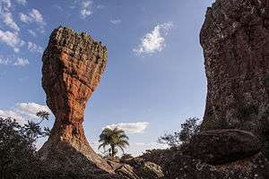
It is famous the sandstone of the Vila Velha Park, an example of ruiniform relief. In geological terms the forms visualized are recent, originated during the gondwana megacontinente, where South America was linked to Africa, Oceania, Antarctica and India. In which the ruins lie in the Carboniferous period was a more southern latitude covered by glaciers. The landscape itself was formed after several burials and erosive processes. Different shapes can be found: flutes, dissolution cones, pointed tops, towers and pillars. Although the popular saying has long ago explained that Vila Velha was originated by the action of the wind, geological research however has been stating that it is the fruit of rainwater, action of the solar energy, changes in temperature and activity of living beings on the rock (in discontinuities and shear zone).[67]
Graben
Graben of Ponta Grossa is a tectonic fossa with blocks slaughtered of the NE-SW direction (average values: 3 km wide and 10 km long), where the city is located in the greater part of the urban perimeter. Caused by the displacement of rocks, so that the whole block can descend. The spaces in vain are occupied by rocks of the fault, allowing that rocks of the Itararé Group and of the Ponta Grossa Formation, therefore of rocks of very different ages are at the same statigraphic level. The geological unit of Furnas has a fractured and karstic aquifer where it has been receiving innumerable grants in the last decades for the installation of tubular wells due to water quality. The Itararé Group also has aquifer, although the lower quality is used because it is outcrop, since the Furnas normally be lower. The Ponta Grossa Formation has a good form of water storage but difficult to flow and is usually associated with another two in well records. Being in an urban environment is susceptible of contamination. Other cares refer to the karst relief in Furnas that can cause landslides.[68][69][70][71]
Arch of the Ponta Grossa
It is a rise of the earth's crust on the eastern limit of the Paraná Basin, where Ponta Grossa is located, and therefore receives the name of the city. It arose about 130 million years ago when the South American and African continents were separating. It has an NW-SE direction with NW trim, diabase dikes appear in subparallel bundles near the arch, these same fractures are responsible for the third plateau basalt effluent. In the second plateau but mainly in horizontal fracturing. The topographical degrams are consequence of the arching as well as the older rocks exposed at the edges of the sedimentary basin.[72] There are several parallel faults, aquifers and magnetic alignments that follow the direction of the Arch of the Ponta Grossa.[73] It is believed that the number of resulting dikes does not occur simultaneously, but in a period of 100 years. And not necessarily all if situation to the northwest.[74] The drainage of some rivers that pass through the city and in the region of Campos Gerais is accompanied by canyons, rocky walls and waterfalls as found in the municipality in the São Jorge River, which demonstrates a morfoestrutural control.[75]
Hydrography
The main drainage basin that covers Ponta Grossa is the Tibagi River (original indigenous denotation "Tibaji"), tributary of the Paranapanema River[31] in a hierarchy with the Paraná River. Tibagi covers 6.5% of the entire area of the municipality[76], its tributaries are the Pitangui River which in its margin is subdivided into: Verde, Cará-Cará and Botuquara known in the city. [77]There are no major watercourses on the left bank.[78] The municipality also has the source of the Ribeira River within the Campos Gerais Park in a depression with altitude much smaller than the urban area and it is found in the 1st Planalto (Plateau of Curitiba).[77][79]
The area is considered well irrigated even if it has relatively small basins outside the Tibagi River that covers the whole region. With the retention of moisture has its rapid displacement to the main water flows.[31] Some of the region's rivers are affected by structural controls. Many times it accompanies faults, fractures and dikes in the direction of the Arch of Ponta Grossa (NW-SE). In addition the route of these rivers accompanies a high altimetric gradient that favors the construction of hydroelectric power plants, so much that some barrages are in functioning as in the Pitangui River.[80] The drainage pattern normally found is radial.[81]
Pitangui River, one of the most important rivers of the municipality was dammed in 1939 originating the Dam of the Alagados. The same is responsible for the water supply in the city, also by the direct capture of the river. There are, however, problems associated with aggradation and eutrophication.[82] The presence of agriculture, industrial effluents and vehicular traffic instead of the riparian forest affects the chemistry of water with levels of chlorides, phosphors and alkaline.[83]
In all there are 12 drainage basins in the municipality. They are: Ronda, Olarias, Pilão de Pedra, Lajeado Grande, Santa Tereza, Cará-Cará, Francelina, Santa Monica, Grande Arroyo, Taquari, Colônia Adelaide and Gertudes.[77] Of these, there are four streams that are born in the urban perimeter, they were buried and channeled for greater integration of the city. In the past they will have historical importance, but today some watercourses are treated as "sewage" by the local population. Others like arroyo de Madureira had bathing status.[84] With rapid urbanization and without efficient public policies, several arroyos, especially in the 1980s, were occupied by irregular housing. By that it aggravated the quality of the municipal air, a singular characteristic before other cities of Paraná.[85]
Limits
It borders seven municipalities as a whole, although their downtown may be more than 56 miles (90 km) in some cases. To the north are the towns of Castro and Carambeí and Tibagi, to the south are the towns of Palmeira and Teixeira Soares, to the east is the city of Campo Largo, and to the west are is Ipiranga.[31]
 |
Tibagi (73.2 km or 45.5 mi) | Carambeí (inside) | Carambeí (22.5 km or 14 mi) |
| |||
| Ipiranga (57.7 km or 35.9 mi) | Campo Largo (inside) | ||||||
| Teixeira Soares (56.4 km or 35 mi) | Palmeira (46.3 km or 28.8 mi) | Campo Largo (87.9 km or 54.6 mi) |
Demographics
| Historical population | ||
|---|---|---|
| Year | Pop. | ±% |
| 1824 | 1,330 | — |
| 1835 | 2,250 | +69.2% |
| 1842 | 3,200 | +42.2% |
| 1870 | 6,490 | +102.8% |
| 1890 | 4,774 | −26.4% |
| 1900 | 8,335 | +74.6% |
| 1920 | 20,171 | +142.0% |
| 1940 | 29,360 | +45.6% |
| 1950 | 42,875 | +46.0% |
| 1960 | 77,803 | +81.5% |
| 1970 | 112,253 | +44.3% |
| 1980 | 171,818 | +53.1% |
| 1990 | 246,738 | +43.6% |
| 2000 | 266,552 | +8.0% |
| 2010 | 311,611 | +16.9% |
| 2018* | 348,043 | +11.7% |
| *population estimate. [2] Source: | ||
For the data collected by the census the population in 2010 was 311,611 inhabitants with a density of 150.72 inhabitants/km², for an estimate of 2018 the value is 348,043 inhabitants of Paraná.[2] For IPARDES the estimate for 2030 is 381,051 inhabitants, a burden of 109.48%, but for this simulation, São José dos Pinhais would surpass Ponta Grossa in population, which would lower the second to the fifth place in the state.[88] Historically its geographical condition was important for the population increase, from the breeding and wintering to the yerba mate and wood and finally the services sector.[89]
Ponta Grossa grew faster in the late 17th century, though Jesuits had settled a century earlier. Used as a breeding ground for the troops of Viamão due to natural pasture, in the freguesia in 1853 there were 3,033 people (1652 men and 1381 women). In 1877 by order of the Empire, this city as well as other of the south of Brazil received immigrants such as: Poles, Germans, Ukrainians, Russians and Italians, generating a cultural broth and increasing population. Demographic growth continued at the end of the same century with the railway under construction. Finalized, it allowed greater interconnection between other regions. In 1890 there were 4,774 inhabitants. Being the population concentrated in rail districts in Uvaranas and Oficinas, accompanying of basic services that were coming up successively. Ponta Grossa lives in a historical context of urbanization seen in the south and southeast of the country.[86] The construction of the railroad was translated in decadence of the tropeirismo. Several people from other municipalities came to work in Ponta Grossa for the maintenance of the lines. It also marks an advance in the level of schooling, with elite members holding an undergraduate degree in other Brazilian states.[90] It is in 1940 that it becomes the second largest population contingent of Paraná and consequently reference to the interior of the lost state in the following decade. Guaragi, reincorporated in 1957 (annexed by Palmeira in 1940) brought a new demographic balance.[86]
In 1969 with fiscal incentives in the government of Cyro Martins was installed of new industries, which generated a "bomm" of factories. In the 1980s there was an expansion of the urban network, while the railroad is now located in Uvaranas, accompanied by a better infrastructure and then the growth of the urban network and peripheral neighborhoods. In the later decade there were improvements in other sectors. Other districts have predominantly agrarian characteristics, although Guaragi is closer to an urbanized environment. [86] Ponta Grossa became predominantly urban in the 1970s, in which 52.9% of people lived in urbanized areas. A period that also declines in the rural population that went from 28.2% to 20.2% between the 1980s and 1990s, explained by the mechanization of agriculture, where the labor force migrated to the city (until the 1960s it was only increasing). "Princess of fields" reached a rate of urbanization of 97.5% in the start 2000s. Among the controversial aspects is the intense slump that followed in the last decades of the twentieth century, markedly since 1989 due to rapid urbanization and real estate speculation that generated the "lack" of land (20% were idle). In all, there were 58,730 people living in precarious conditions in 2004. Often residing near urban arroyos sand with buildings in places that should be areas of preservation and inefficient policies for transfer or denial of relocation.[91][92]
Race and Color
| Racial composition | 2010[93] | 2000[94] | 1991[lower-alpha 3][96] |
|---|---|---|---|
| White | 78.66% | 85.16% | 81.28% |
| Negro | 19.7% | 14.08% | 18.21% |
| —Brown (mixed race) | 18% | 11.57% | 16.57% |
| —Afro-Brazilian | 2.7% | 2.51% | 1.64% |
| Asian Brazilian | 0.48% | 0.2% | 0.37% |
| Indigenous | 0.17% | 0.23% | 0.07% |
| Not declared | n/a[lower-alpha 4] | 0.31% | 0.08% |
According to the archives of the region (now state) of São Paulo in 1824 there were 75.1% of whites, together with a small share of pardos (4.8%) and free Afro-Brazilians (0.1%), reaching 80%. Historical data of the Sant'Ann Parish exposes 92.52% whites, with only 6.66% of pardos and 0.82% of Afro-Brazilians. The number of natives was not evaluated. For the same year, 76.52% of Afro-Brazilians and 23.48% of pardos were among slaves. But due to the purchase and sale it is possible to change the values. It is from 1832 that in the maps the natives begin to appear, oscillating to less than 1%.[98] Due to the history of European colonization and slavery not so present as in other regions, even in Paraná, the population is predominantly white. The black population declared is smaller than cities with lower population size such as Cascavel, Foz do Iguaçu and São José dos Pinhais. At the same time the number of whites is lower in these cities, but in relation to "Princess of the Fields" is proportional to their fourth place by total number of people. The indigenous population is larger than Maringá, which has a larger population, and Ponta Grossa is behind only the two largest cities in the state. The yellow population is the smallest in proportion to the number of inhabitants in front of the five largest cities of Paraná, with values closer to cities between 100 thousand and 200 thousand inhabitants, being surpassed by some cities of Paraná, especially in the north of the state.[99] The self-reported white population is higher in the center (91.3%) and the lowest in the south of the city: Cará-Cará (72.6%).[97] The black population has greater expression in Santa Cruz and Sutil, between the limits of Ponta Grossa and Palmeira where they are quilombola refugees, coming from the coast and first plateau.[100][101]
Internal Migration
The migration by internal population contingents follows a geographical logic of proximity and flows. The population also underwent changes due to the limit of the municipality that normally went until the Santa Catarina border to the south, since the registries was by the area covered by the parish. It is noticed that between 1823 and 1879 of the residents of Ponta Grossa who live in the same country or had origin in some city of Paraná (305 people or 8,9%) or of São Paulo, in a greater number: 462 people (13.5%) Among the Paraná cities that contributed most to the population increase were Castro (for historical and economic reasons), followed by Campo Largo, Palmeira, Lapa, São José dos Pinhais, Curitiba, Itapetininga, Itapeva and Sorocaba. But it was not just the two states that made up the population of the city. Rio Grande do Sul had its participation in consequence of the tropeirismo, mainly with the cities of the north of the state: Passo Fundo, Vacaria and Cruz Alta. Other cities that have emerged along the Way of Viamão as well as Ponta Grossa also appear in the origin of the resident princesinos like Lages in Santa Catarina (6 men and 4 women).[102] In recent history Ponta Grossa has received interstate migrants between 1990 and 2010, as a consequence of the dynamics of flows to the mesoregion centers, as has also been occurring in other attractive urban areas of the state.[103]
Immigration
Russians-Germans, Poles and Austrians form the largest group of immigrants of the nineteenth and twentieth centuries. By the civil registry in the Sant'Ana Registry, one of the principal of the city, the largest registry of grooms between 1889 and 1920 are from the previous three, which proves the affirmative. They are 257 Poles, 102 Germans and 64 Austrians, with booms in different decades according to the biggest waves of immigrants.[104] Since 1870, Empire politicians have encouraged European immigration to the country, considering their advanced agricultural techniques and seeking to fill areas. Although inhabited, were often surrounded by forests and depopulated regions such as the case of Paraná. Other reasons were the lack of the basic foodstuffs.[105][106] Most of the population was focused on yerba mate production and there were no more slaves for free labor.[21] Immigrants were brought in with the ideal of being French-style "progress" for the city, based on other large urban centers.[90] Russian-Germans of the banks of the Volga River were added in 1878, 2831 settlers that lived in Octavio Colony, the first in the city (divided locally in 17 nuclei), that moved towards the richer grounds due to the failed harvest, as an alternative the labor was sought in the production of coal by pine knot, this time occupied by Europeans of the center-south of the continent: Germans, Italians and Poles. The most famous Teuta-Brazilian was Henrique Thielen, reimmigrated back to Brazil and who was the director of the Antartica Brewery. Or the Italian Eugenio Bocchi, a businessman from a soap factory from Curitiba who lived in the city. During the same period Dom Pedro II was in the city and heard the complaints, especially on the ground poor between the east and northeast of the municipality. Taquari and Moema had the best conditions. And the Adelaide Colony stood out for the transport of mate taken by wagons to Curitiba.[105][106] Colonies of Guarauna, Guarauninha, Taquary, Rio Verde, Eurydice, Trindade, Dona Adelaide, Botuquara, Tavares Bastos, Floresta, Itaiacoca, Moema and Tibagi together with the Octavio Colony, 975 people are added to the balance of municipality and adjacencies.[21]
Between 1885 and 1886 an immigration society was created in Ponta Grossa. It was the responsibility of the federal government to create propaganda to "force" the migrations, and also the construction of the railroad. Still on the railroad was important for the solidification of the city and especially the commerce. In the last decade of century XIX marks the arrival of the Syrians. They provided workers to the road and were known for the production of farm and haberdashery. Neighborhood such as Uvaranas, Dona Luiza and Ronda were formed by immigrants. Usually associated with some specific technical work or service, thus forming the local workforce.[105][106] Jews and Greeks as too Syrians-Lebaneses were important to local commerce. [107] Other ethnic groups include arabs that reflect in the gastronomy.[108] Independently of the origin, a large part of the immigrants had importance for the economic base of Ponta Grossa, several commercial establishments and services were created, from tailoring to butchers and same industrial activities. Emerging, therefore, as social actors of the city. In coexistence with different social classes and ethnicities.[90]
Germans
The choice of Ponta Grossa, among other South-Brazilian cities was due to bioclimatic conditions more similar to the Low Volga, not far from the Caspian Sea. When they got the settlements, they established a long street (Strassendorf) occupied on both banks.[109] Among the German immigrants, some re-emigrated from the Dona Francisca Colony (from 1875 in the present city of Joinville[110]). Jens Jansen came riding from Curitiba to Ponta Grossa establishing in the farm of Jose Miró, in 1877 he lived in Colônia Moema, time that came a leads directly to the city. Many families were adapting to different places, like some that came from Santa Catarina. But the settlement itself was between 1877 and 1879 mainly. Some colonies were separated due to the religious aspect, Tavares Bastos, for example was Catholic different from other groups of Lutheran tradition. It is believed that the cost of housing an immigrant was 60 milreis.[111] The assistance of Alfredo Heinsler to the Volga Germans is remarkable. In 1927 he and the immigrants celebrate the centennial of immigration. Besides the Otavio Colony, the oldest settlement of the Volga Germans, there were other immigrant villages such as the Euridice Colony in the Chapada Neighborhood where there is the house of August Jansen, one of these immigrants from the period with his name indicated in his house.[112] Among other colonies were formed, subdivided of the oldest colony such as: Moema, Tavares Bastos, Conchas/Uvaia and Dona Luiza. Guarauna was one of the largest with 322 settlements, followed by Adelaide (142) and Tavares Bastos (112).[113] Family farming and livestock were base. This as well as other colonies did not obtain success with the planting of wheat that had been replaced by other cereals.[112] Trade was also practiced, usually located in areas that were not typically agrarian, but in transition to urban. Many of them moved to the city end of the same century. The ability of woodworking by these immigrants is recognized.[90] Due to failure, there were only 323 families left in Brazil Republic, out of 615. They were usually seen as persistent because they tried to get their crops to succeed. Dom Pedro II was during the repercussion on the poor soils of the Campos Gerais.[114] Volga Germans were encouraged not to lose their customs of their ethnic origin by which they were replicated in written publications.[115] In 1917 were registered in Ponta Grossa 84 Germans, is the second largest German community, being behind only of Curitiba. In the following year it is surpassed by Guarapuava, remaining in the third place with 29 new registered immigrants, adding between 1917 and 1918 to the whole 9.7% of the police record of Paraná.[116]
Poles
The Poles settled in 1878 in the settlement called Colony Moema abandoned by the Germans who complained of the dry fields due to their low fertility. With about 26 families (84 people) coming from Tarnnow, southern Poland who were waiting somewhere in the metropolitan area of Curitiba, being the first of the ethnic group. In January 1891, a new group of Poles arrived, distributed in more colonies and, consequently, in a larger number of people: Colony of Taquari (125), Guarauna (140), Rio Verde (78), Butuquara (73), Itaiacoca (46) and Euridice (23), in the municipality of Ponta Grossa. In Conchas, today annexed to the municipality went to Adelaide (99) and Floresta (29). At 6.2 miles (10 km) from the Center, the Guaraúna and Taquari Colonies are the largest immigrants in quantity. Some colonies had no planning and were built of wattle and daub, covered with straw and wood, in the condition of poverty they tried to go until the "ranchões" (place that the immigrants are situated to wait their constructed houses).[107] As the heritage of the Poles there is the Sacred Heart Church of Jesus, the lambrequins seen near the rooftops and the Polish Renaissance Society (a dance club built in 1934).[117] The club served for many years as a meeting place for descendants of Poles, to build it there was a need for many people.[118] Gary Dvoreck, the then president of the Polish Society, was against the tipping of the Renaissance Club in 2012.[119] He believes that after being overthrown it would not be possible to make reforms. In 2017 Polish club was at risk of demolition (by which it was denied) and thus came the disclosure of reforms.[118][120] The Campos Gerais Museum exhibited in 2012 the traditions, the dances folklores, the elements of the first immigrants as well as the Polish architecture.[121] Also the typical costumes pisanki, wycinanki and lepianka, there were a version of Matryoshka, the Christmas wafer: oplatek and Christmas tree, one of the first versions of the ornament.[122] Periods were a form of socialization of the Polish community in Brazil. In Ponta Grossa there was the Sowirzdrzal w Paranie ("The pesky ones in Paraná").[123]
Population pyramid
| Population pyramid 2010[124] | ||||
| % | Males | Age | Females | % |
| 0.1 | 85+ | 0.4 | ||
| 0.3 | 80–84 | 0.5 | ||
| 0.5 | 75–79 | 0.8 | ||
| 0.8 | 70–74 | 1.1 | ||
| 1.1 | 65–69 | 1.4 | ||
| 1.6 | 60–64 | 1.9 | ||
| 2.1 | 55–59 | 2.4 | ||
| 2.6 | 50–54 | 2.9 | ||
| 3.0 | 45–49 | 3.4 | ||
| 3.3 | 40–44 | 3.6 | ||
| 3.6 | 35–39 | 3.8 | ||
| 4.0 | 30–34 | 4.2 | ||
| 4.2 | 25–29 | 4.2 | ||
| 4.4 | 20–24 | 4.3 | ||
| 4.6 | 15–19 | 4.5 | ||
| 4.6 | 10–14 | 4.5 | ||
| 4.0 | 5–9 | 4.0 | ||
| 3.8 | 0–4 | 3.7 | ||
Ponta Grossa, as well as the southern half of Brazil, live a demographic transition period, where the largest population is no longer in the children's zone, but has not yet reached the highest peaks in adulthood, a trend of the future. The number of elderly people has been increasing, although in larger proportion in the female sex. The population over 65 years of age reaches 21416 (2010, 6.87% of aging index). Currently, considering the 2010 census, the largest age group is between 15 and 24 years old, therefore a predominance among adolescents and young people, making the population pyramid with a "leaf" shape rather instead triangular aspect in in comparison to the previous two decades. There are other phases of higher growth in relation to age bands before or after them, such as 5-9 years (before) and 10-14 years (after). However, the number of inhabitants 80 and older is not so different as the number of 1-year-olds (4109 vs 4376). Over 30 years old there is predominance of female gender, an opposite situation in the infantile-juvenile phase, where the male sex loses only at the age of 7 years. In a total balance, women predominate (51.43%) with 160249 residents of the sex, a proportion similar to 1991. Men corresponded to a figure of 9,000 below the total number of women, altogether 151362 (48.57%). In the last decade the ratio of adolescents' dependence on the financial issue has reduced to less than half, in 1991 it was 60%.[125][126]
Religion
As the main colonizers were Iberians and descendants of other regions of Brazil during the first settlements and emergence of farms, the main religion is the Roman Catholic Church. In turn it reflects even in the mode of establishment of the city (settlement linked to the location of the parish and patrons of Catholicism). And it interrelated with the history of the "Princess of the Fields", as the Santa Barbara Chapel founded by Spanish Jesuits is the oldest of the Campos Gerais, founded in the eighteenth century. Even the decree was in devotion to St. Anne. Known as the grandmother of Jesus in the Catholic tradition the same is the patroness of Ponta Grossa and by the strong influence of religion on July 26 is municipal holiday. The construction of the chapel was in 1823 in a former shelter of tropeiros that marks the beginning of the village. Other buildings that are also part of the religious patrimony are the Immaculate Conception Church ("the little church of Uvaranas") and the Sacred Heart of Jesus Church ("the church of the Poles"). Religious festivals take place annually as Feast of the Divine Holy Spirit and of the Lady Saint Anne. The city houses the Resurrection Monastery and a monument dedicated to the bible. [127] On December 16, 1929 the Diocese of Ponta Grossa was created, Cardinal Henrique Gasparri took on in February 23, 1930. Bishop Antônio Mazzarotto built spaces that provided for the formation of religious as seminaries and congregations of religious sisters.[128] Since September 5, 2003, bishop Sergio Arthur Braschi is the bishop of the Diocese of Ponta Grossa.[129]
For the 2010 census, 209,678 people identify themselves as Roman Catholics (67.29%). The second largest in number is the Evangelical Church in general with 74842 followers (24.02%). Among the religious minorities with more than 1,000 believers are Spiritism (2.35%), Church of Jesus Christ of Latter-day Saints (0.89%), Jehovah's Witnesses (0.48%) and other Christian religions summed up (0.47%). Hundreds of people follow Buddhism (0.10%), Umbanda (0.04%), Esotericism (0.06%), Catholic Churches that do not obey the papal hierarchy (0.14%) and new Eastern religions as a whole (0.04%). Other religious groups are usually isolated in proportional numbers of families as if they were from the same kinship or few expressive in percentage terms. The number of people without religion is greater than the number of believers of the major non-Christian religions in the municipality. They are 11422 who declare that they have no affiliation with an institution of any creed (3.67%), although only slightly more than a tenth identify themselves as either an atheist (0.29%) or an agnostic (0.06%). People like more than one religion reach 0.32% and do not know 0.04%. Religions that are generally classified as Christian add up to 286,414 people or 91.91% of the city's population. Adding a value of 4.41% for other religions.[130]
There have been events to bring Christian religions closer together like the Semana de Oração pela Unidade Cristã (in English: Week of Prayer for Christian Unity). A project of ecumenical reconciliation, involving biblical symbols between institutions.[131] The diocese of the municipality studies reactivating the hermitage, seen prominently for people who pass through the BR-376 and see the Vila Velha Park and see the structure in the shape of an elongated cone. It became a shrine on July 25, 1983 designed by Bishop Geraldo Pellanda. The same falls within a religious tourism project. Periodic celebrations should be held as well as gatherings, retreats and events. However, it was passed to the technical analysis of the responsible environmental agency in the state.[132] During the first week of October 2018, it was authorized the reform of the hermitage with a budget of 300 thousand reais (77800 dollars[lower-alpha 5]) and it is very likely to reopen in 2019 for religious tourism with the support of the local tourism foundation. The sanctuary emerged in the late 1970s.[134]
Tourism
There are many tourist attractions in Ponta Grossa, many of them unaccessible by public transport.
Attractions
- Vila Velha State Park (in Portuguese: Parque Estadual de Vila Velha), a park made up of rocky formations formed over millions of years. Each rock formation has its own name, depending on which object or animal they look like.
- Priest's Hole (in Portuguese: Buraco do Padre) and Mariquinha Fall (in Portuguese: Cachoeira da Mariquinha), both private properties.
For nautical sports, tourists and ponta-grossenses have Alagados, 7.5 miles from downtown. Access to it is by paved and unpaved roads. The most common adventure sport in the region is climbing, in the countryside of Ponta Grossa.
The city is home to historic architecture. Examples include Vila Hilda Mansion, the former train station Paraná (in Portuguese: Estação Paraná—Casa da Memória), Art Station, Longing Station, the Campos Gerais Museum, the Epoch Museum, the Opera Theatre, Planalto Palace Hotel, and more.
Some of the religious attractions are the Resurrection Monastery, Rosario Church, Santa Barbara Chapel, Santana Cathedral, and São José Graveyard.
There are annual events, such as the National Stout Festival, called Münchenfest, with typical German dances and concerts featuring national and international artists. Other events include the Grape Festival, Rodeo of Rodeos, and the Campos Gerais Farming and Cattle Raising Fair.
Education
The city has two public colleges:
- Ponta Grossa State University (UEPG) (Pt: Universidade Estadual de Ponta Grossa)
- Parana Federal Technological University (UTFPR) (Pt:Universidade Tecnológica Federal do Paraná)
Both institutions attract undergraduate and graduate students from many regions, mostly from the south of Brazil. The city also has private colleges as Faculdades Uniao, Faculdades Santa Amelia (Secal) e Sant'Ana, Centro de Ensino Superior dos Campos Gerais (Cescage) and a campus of Centro Universitário Campos de Andrade (Uniandrade).
Culture
Ponta Grossa has three theaters, movie theaters, art galleries and spaces for visual arts and music expositions and events. Ponta Grossa State University (UEPG) offers majors in Visual Arts and Music. The city also has its own orchestra, the Ponta Grossa Symphony Orchestra, and the Paulimo Martins Music School.
Museum
- Campos Gerais Museum
- Epoch Museum
- Egyptian Museum
- Casa da Memória Paraná
Theaters
- Opera Theater
- Marista Theater
- Pax Theater
Cinema
- Multiplex Palladium
- Cinema Lumière
Art Galleries
- Culture Center City of Ponta Grossa
- Pinacotheca Cidade de Ponta Grossa
Public administration
The municipal government is composed of an executive, headed by the Mayor and his Secretariat, and a legislative branch, represented by the City Council. The sitting mayor is Marcelo Rangel.[135] The Municipality of Ponta Grossa is composed of 14 aldermen (or is it 15) elected to four-year terms.
Notable residents
Economy
The economy of Ponta Grossa had three great drives during the twentieth century. The first in mid-1900 with the installation of the railway, the second in the 1970s with the installation of large industrial area of food and milling, and the third in the second half of the 1990s with the establishment of large national companies in the logistics sector and production and investment of large networks of the service sector.
The city is close to major consumer markets of Brazil in São Paulo and Curitiba, and is a conduit for the export of goods through the port of Paranaguá and the Hall of Mercosur, the highway that connects the south of Brazil with Mercosur countries. It is the fourth largest city in Paraná by exports and the tenth in the South.
Industries
About ten miles from the center of Ponta Grossa is the Industrial District Ciro Martins. The complex, located next to the Gothic region Sesa, is the largest in the state, behind Curitiba and its metropolitan area. The city has industries in the following areas: the extraction of talc, livestock, agro-industry (particularly soybeans, which gives the town the title Soybean Capital of the World), timber, metals, metals, food, textiles.
Some industrial plants installed in Ponta Grossa are Monofil, LP Masisa, Makita, Femsa Brewery, Continental, Tetra Pak, Beaulieu of Brazil, Louis Dreyfus, Cargill, Bunge, Batavia, Sadia, among others especially the food-milling industry. In the Industrial District is also installed is the granary of CONAB (National Supply Company), the largest store of grain in Brazil, with load capacity to 420 tons. In August 2011, Paccar announced it selected a 200 hectare industrial site, to build a 4 hectare facility to build DAF trucks. The facility will employ about 500 workers directly.[136]
The industrialization process took place in the city during the period between 1975 and 2005 driven by strong transportation infrastructure and cheap skilled labor, with the presence of Universidade Estadual de Ponta Grossa (UEPG), and since 1991, Federal Technological University of Paraná (UTFPR).
Services
Because of its grand trunk road, Ponta Grossa is known as the capital of the truck. The sector that operates in this area is largely developed and diverse, attracting fleet owners and truck drivers of all parents to make repairs on their vehicles, this sector is concentrated in regions of Av Souza Naves, Av Pres. Kennedy and PR 151.
In the service sector, the city has large supermarket chains, shopping malls, popular fast-food, as well as large national stores and regional department, electronics and retail.
The city has one of the highest GDPs in the state of Paraná and, paradoxically, has pronounced deficits in infrastructure. Evidence of this are the numbers of IPARDES 2007, indicating that Maringá has a similar population, but with more water supply and sewerage, increased paved area and a smaller number of people in poverty.
According to research conducted by Revista Você S/A, Ponta Grossa is the 84th best city to make a career in Brazil.
The city is served by Ponta Grossa Airport.
Notes
- ↑ Mean monthly maxima and minima (i.e. the expected highest and lowest temperature readings at any point during the year or given month) calculated based on data at said location from 1961 to 1990.
- ↑ Mean monthly maxima and minima (i.e. the expected highest and lowest temperature readings at any point during the year or given month) calculated based on data at said location from 1954 to 2001. Therefore, completely covering the series from 1960-1990, plus an earlier and later period.
- ↑ The 1990 census was postponed to the following year, the IBGE affirms the lack of employees and the conditions for the realization seemed incomplete (according to news announced by Jornal do Brasil).[95]
- ↑ There is only one person stated which makes it meaningless in percentage terms.[97]
- ↑ The exchange rate and conversion of Brazilian Reais (BRL) to US dollars (USD) is valid for October 6, 2018. Being 1 BRL equivalent to 0.259333 USD.[133]
References
- ↑ "IBGE" (in Portuguese). Instituto Brasileiro de Geografia e Estatística. Retrieved April 26, 2018.
- 1 2 3 4 5 6 "Ponta Grossa - Overview". cidades.ibge.gov.br. Retrieved 2018-08-30.
- ↑ "IBGE" (in Portuguese). Instituto Brasileiro de Geografia e Estatística. Retrieved August 30, 2018.
- ↑ "Microregion of Ponta Grossa". www.cidade-brasil.com.br. Retrieved August 30, 2018.
- 1 2 "Ponta Grossa, a princesa dos Campos Gerais, comemora 193 anos na quinta". Campos Gerais e Sul (in Portuguese). 2016-09-12. Retrieved 2018-08-30.
- ↑ Sérgio De Melo, Mário; Valéria Medeiros, Carla; César, Paulo; Giannini, Paulo; Garcia, Maria; Carlos, Luiz; Pessenda, Luiz (2003-01-01). "Sedimentação quaternária no espaço urbano de Ponta Grossa, Pr". Geociências. 22.
- ↑ Nascimento, Ederson; Matias, Lindon Fonseca (2011-11-03). "EXPANSÃO URBANA E DESIGUALDADE SOCIOESPACIAL: UMA ANÁLISE DA CIDADE DE PONTA GROSSA (PR)". Raega - O Espaço Geográfico em Análise (in Portuguese). 23 (0). doi:10.5380/raega.v23i0.24833. ISSN 2177-2738.
- ↑ Pavan, Ludmilla (2017-08-23). "Unforgettable places to visit in Paraná". Bonde.
- ↑ "Ponta Grossa e sua natureza caprichosa | Arquivo Tribuna, Viagem e Turismo | Tribuna PR - Paraná Online". Tribuna PR - Paraná Online (in Portuguese). 2006-03-29. Retrieved 2018-08-30.
- ↑ "Campos Gerais Path". Jornal da Manhã: 130. 2017.
- ↑ "Ponta Grossa é indústria". Revista Ideias (in Portuguese). 2017-09-04. Retrieved 2018-08-30.
- ↑ "PG tem o 2º maior PIB industrial do interior do PR". A Rede (in Portuguese). 2017-02-17. Retrieved 2018-08-30.
- 1 2 3 imprensa. "Origem do Nome". www.pontagrossa.pr.gov.br. Retrieved 2018-08-30.
- ↑ "Por que a cidade de Ponta Grossa tem esse nome? | Blog do Curioso, por Marcelo Duarte". guiadoscuriosos.uol.com.br (in Portuguese). Retrieved 2018-08-30.
- ↑ "Tourism Booklet" (PDF). Ponta Grossa City Hall (in Portuguese). Coordination of the Professional Qualification Program for the Tourism Sector of Ponta Grossa. Retrieved September 4, 2018.
- ↑ "Historiador conta sobre a origem de Ponta Grossa". A Rede (in Portuguese). 2017-09-15. Retrieved 2018-09-02.
- 1 2 3 4 5 6 7 8 9 10 11 12 13 FERREIRA, João Carlos Vicente (1996). O Paraná e seus municípios. Maringá: Memória Brasileira Publish Company. 535 pages
- 1 2 3 4 5 6 7 "História de Ponta Grossa | The Cities". www.thecities.com.br (in Portuguese). Retrieved 2018-09-03.
- ↑ "Você sabe o que são tropeiros e a sua importância? | Conceito Sertanejo". 2018-09-03. Retrieved 2018-09-03.
- 1 2 3 4 imprensa. "História da Cidade". www.pontagrossa.pr.gov.br. Retrieved 2018-09-03.
- 1 2 3 Kohlrausch, Arlindo Jonas Fagundes (2007-03-22). Introdução à história da arquitetura de Ponta Grossa / PR: as casas de madeira - 1920 a 1950 (Thesis) (in Portuguese). Universidade de Sao Paulo Sistema Integrado de Bibliotecas - SIBiUSP. doi:10.11606/D.16.2007.tde-19052010-102628.
- ↑ "MEMÓRIA E HISTÓRIA: CAPELA SANTA BÁRBARA DO PITANGUI". www.histedbr.fe.unicamp.br. Retrieved 2018-09-11.
- ↑ "Foreigners in the Settlement". Diocese of Ponta Grossa. 2017-09-03. Archived from the original on September 3, 2017. Retrieved 2018-09-02.
- ↑ "SIGEP - Sitio 029 - VILA VELHA" (in Portuguese). Geological and Palaeontological Sites of Brazil. 2012-06-20. Archived from the original on June 20, 2012. Retrieved 2018-09-02.
- ↑ "PROFESSIONAL RAILWAY SCHOOL CEL. TIBÚRCIO CAVALCANTI DE PONTA GROSSA (1940 - 1973) A MODEL OF EDUCATION PROFESSIONAL" (PDF). Histedr Unicamp. Campinas State University. 2016-03-12. Archived from the original (PDF) on March 12, 2016. Retrieved 2018-09-02.
- 1 2 "Ponta Grossa: History and Historiography in the construction of the City Crossroads". International Congress of History UEPG-UNICENTRO. Archived from the original (PDF) on September 10, 2018. Retrieved September 3, 2018.
- ↑ "Paraná on the route of the revolutionaries". Gazeta do Povo (in Portuguese). Retrieved 2018-09-02.
- ↑ "Ponta Grossa, a "Princesa dos Campos" - Notícias - Fiep - Nosso Sistema". www.fiepr.org.br. Retrieved 2018-09-04.
- ↑ "History of Ponta Grossa". cidades.ibge.gov.br. Brazilian Institute of Geography and Statistics. Retrieved 2018-09-03.
- ↑ Queiroz, Dulcina; Eurich, Zíngara Rocio Santos; Carvalho, Silvia Méri (2016-05-14). "ESPAÇOS LIVRES EM PONTA GROSSA-PR: MAPEAMENTO E QUANTIFICAÇÃO". Boletim de Geografia (in Portuguese). 33 (0): 1–12. doi:10.4025/bolgeogr.v33i0.31917. ISSN 2176-4786.
- 1 2 3 4 5 6 7 8 9 10 11 12 "Environmental Aspects" (PDF). City Hall of Ponta Grossa.
- ↑ imprensa. "Localização". www.pontagrossa.pr.gov.br. Retrieved 2018-08-30.
- ↑ "Você conhece a história da região dos Campos Gerais?". www.diariodoscampos.com.br (in Portuguese). Retrieved 2018-09-01.
- ↑ "Regional Readings: Geographical Meso-Regions of Paraná" (PDF). IPARDES. IPARDES/Government of Paraná. Retrieved September 1, 2018.
- ↑ CELEPAR. "class_clim - Instituto Agronômico do Paraná - IAPAR". www.iapar.br (in Portuguese). Retrieved 2018-08-30.
- 1 2 CELEPAR. "Classclim_apresentacao - Instituto Agronômico do Paraná - IAPAR". www.iapar.br (in Portuguese). Retrieved 2018-08-30.
- ↑ "Clima: Ponta Grossa: Climograma, Temperatura e Tabela climática Ponta Grossa - Climate-Data.org". pt.climate-data.org. Retrieved 2018-08-31.
- ↑ "Plant Hardness - South America".
- ↑ "MAPEAMENTO DOS PLANTIOS FLORESTAIS DO ESTADO DO PARANÁ - PINUS E EUCALYPTUS" (PDF).
- ↑ Cruz, Gilson Campos Ferreira da (2009-11-26). Clima urbano em Ponta Grossa - PR: uma abordagem da dinâmica climática em cidade média subtropical brasileira (Thesis) (in Portuguese). Universidade de Sao Paulo Sistema Integrado de Bibliotecas - SIBiUSP. doi:10.11606/T.8.2009.tde-05022010-141629.
- ↑ "Historic Serie of the Ponta Grossa (minimum temperaure)". INMET (in Portuguese). Retrieved August 30, 2018.
- ↑ "Historic Serie (maximum temperature)". INMET (in Portuguese).
- ↑ "Serie Historic - Precipitation (mm)". INMET (in Portuguese). Retrieved August 30, 2018.
- ↑ "Serie Historic - Humidity". INMET (in Portuguese). Retrieved August 30, 2018.
- ↑ O dia começou com neve em Ponta Grossa - G1 Paraná - Paraná TV 1ª Edição - Vídeos - Catálogo de Vídeos, retrieved 2018-08-31
- ↑ "Snow of 1975: a pleasant surprise". Bem Paraná (in Portuguese). Retrieved August 30, 2018.
- ↑ "Onda de frio de Julho/1981". meteobrasil.forumeiros.com (in Portuguese). Retrieved 2018-08-31.
- 1 2 "A neve em Palmas/PR: da reconstituição histórica à abordagem dinâmica" (in Spanish). Zavattini, João Afonso [UNESP], Universidade Estadual Paulista (UNESP). 2004.
- 1 2 "NORMAIS CLIMATOLÓGICAS DO BRASIL 1961-1990" (in Portuguese). Instituto Nacional de Meteorologia. Retrieved 4 July 2015.
- ↑ "Tornado atinge Ponta Grossa (PR)". Bom Dia Brasil (in Portuguese). 2010-12-20. Retrieved 2018-09-25.
- ↑ "Ponta Grossa amanhece com neblina intensa". A Rede (in Portuguese). 2015-06-02. Retrieved 2018-09-25.
- ↑ "Neblina pode ter sido causa de acidente na Souza Naves". www.diariodoscampos.com.br (in Portuguese). Retrieved 2018-09-25.
- ↑ "Nevoeiro impediu que Alok pousasse para fazer show". A Rede (in Portuguese). 2018-03-11. Retrieved 2018-09-25.
- ↑ "Neblina provoca engavetamento e mortes no Paraná - Brasil - Estadão". Estadão (in Portuguese). Retrieved 2018-09-25.
- ↑ "Nevoeiro desfalca XXXPERIENCE e TribalTech; entenda o caso". www.phouse.com.br (in Portuguese). Retrieved 2018-09-25.
- ↑ "IAPAR weather station (02550024), 1954-2001" (in Portuguese). Instituto Nacional de Meteorologia. Retrieved 11 September 2018.
- 1 2 3 "Characterization of the natural heritage of the Campos Gerais of Paraná" (PDF). UEPG. Retrieved September 4, 2018.
- 1 2 Meneguzzo, Isonel Sandino; Albuquerque, Edu Silvestre (2009-10-03). "A política ambiental para a região dos Campos Gerais do Paraná". Raega - O Espaço Geográfico em Análise (in Portuguese). 18 (0). doi:10.5380/raega.v18i0.13360. ISSN 2177-2738.
- ↑ Takeda, Adalberto Koodi; Takeda, Inês Janete Mattozo; Farago, Paulo Vitor (2001). "UNIDADES DE CONSERVAÇÃO DA REGIÃO DOS CAMPOS GERAIS, PARANÁ (CONSERVATION UNITS OF THE CAMPOS GERAIS REGION, PARANÁ)". Publicatio UEPG: Ciências Biológicas e da Saúde (in Portuguese). 7 (1). doi:10.5212/publicatio%20uepg.v7i1.267. ISSN 1809-0273.
- 1 2 Martorano, Lucieta (2004-01-01), Solos, Clima e Vegetação da Região de Campos Gerais, ISBN 885864133 Check
|isbn=value: length (help), retrieved 2018-09-04 - ↑ "Atlas Geomorfológico do Paraná" (PDF). Archived from the original (PDF) on
|archive-url=requires|archive-date=(help). - ↑ "GEODIVERSITY OF PONTA GROSSA - BASE FOR TOURISM AND EDUCATION". Geocultura. Archived from the original (PDF) on
|archive-url=requires|archive-date=(help). Retrieved September 2, 2018. - ↑ Barreto, Karla Thais; Pinto, Maria Ligia Cassol (2017-09-01). "CARACTERIZAÇÃO DOS INDICADORES GEOMORFOLÓGICOS NA BACIA HIDROGRÁFICA DO RIO VERDE, PONTA GROSSA – PR". Geografia Ensino & Pesquisa (in Portuguese). 21 (2): 164–173. doi:10.5902/2236499424088. ISSN 2236-4994. Archived from the original on
|archive-url=requires|archive-date=(help). - ↑ CELEPAR. "Folha de Ponta Grossa - Diretoria de Geologia (Mineropar) - Instituto de Terras, Cartografia e Geologia do Paraná-ITCG" (PDF). www.mineropar.pr.gov.br (in Portuguese). Archived from the original on
|archive-url=requires|archive-date=(help). Retrieved 2018-09-02. - ↑ "STRUCTURAL ANALYSIS OF MACHINE DAMES EOCRETACEOS OF SOUTH-SOUTH BRAZIL" (PDF). Teses USP. University of Sao Paulo. Archived from the original (PDF) on
|archive-url=requires|archive-date=(help). Retrieved September 2, 2018. - ↑ Volkmer, Susana; Camolezi, Bruno Aurélio; Ribeiro, Matheus Aparecido Godoy (2010-12-23). "Geomorfologia da quadrícula de Ponta Grossa, PR – uma ênfase aos recursos geotecnológicos utilizados - doi: 10.4025/bolgeogr.v28i2.10614". Boletim de Geografia (in Portuguese). 28 (2): 29–40. ISSN 2176-4786. Archived from the original on
|archive-url=requires|archive-date=(help). - ↑ CELEPAR. "Parque Estadual Vila Velha - Diretoria de Geologia (Mineropar) - Instituto de Terras, Cartografia e Geologia do Paraná-ITCG". www.mineropar.pr.gov.br (in Portuguese). Retrieved 2018-09-02.
- ↑ Sérgio de Melo, Mário; César Fonseca Giannini, Paulo (2007). "Sandstone dissolution landforms in the Furnas Formation, southern Brazil". Earth Surface Processes and Landforms. 32 (14): 2149–2164. doi:10.1002/esp.1520. ISSN 0197-9337. Archived from the original on
|archive-url=requires|archive-date=(help). - ↑ Melo, Mario Sérgio De; Gomes, Ricardo Marins; Pereira, Gabriela Kostrzewycz (2015-10-13). "ÁGUA SUBTERRÂNEA NO GRÁBEN DE PONTA GROSSA, PR". Boletim Paranaense de Geociências (in Portuguese). 72 (0). doi:10.5380/geo.v72i0.35937. ISSN 0067-964X.
- ↑ "HYDROGEOLOGICAL CHARACTERISTICS OF PONTA GROSSA, PR" (PDF). UEPG (in Portuguese). UEPG Geography Week.
- ↑ "QUALITY OF UNDERGROUND WATER IN THE PONTA GROSSA (PR) GRABEN REGION" (PDF). UEPG (in Portuguese). UEPG Geography Week. Retrieved September 7, 2018.
- ↑ "Dicionário Histórico e Geográfico dos Campos Gerais: Arco de Ponta Grossa". www.uepg.br. Retrieved 2018-10-07.
- ↑ Michael, Strugale, (2002). "Arcabouço e evolução estrutural do arco de Ponta Grossa no grupo Sao Bento (mesozóico) : implicações na hidrodinâmica do sistema aqüífero guarani e na migração de hidrocarbonetos na Bacia do Paraná".
- ↑ Raposo, Maria Irene Bartolomeu (2017-08-03). "EPISÓDIOS INTRUSIVOS NO ARCO DE PONTA GROSSA, DETERMINADOS ATRAVÉS DE UM ESTUDO PALEOMAGNÉTICO". Revista Brasileira de Geociências. 25 (1): 3–19. ISSN 0375-7536.
- ↑ "LINEAMENTOS ESTRUTURAIS DA BORDA ORIENTAL DA BACIA SEDIMENTAR DO PARANÁ: UM ESTUDO ENTRE CARAMBEÍ E PONTA GROSSA, NOS CAMPOS GERAIS DO PARANÁ". www.periodicos.ufam.edu.br (in Portuguese). Retrieved 2018-10-07.
- ↑ "Drainage basin of the Paraná" (PDF) (in Portuguese). Retrieved August 31, 2018.
- 1 2 3 "Águas de Ponta Grossa | The Cities". www.thecities.com.br (in Portuguese). Retrieved 2018-08-31.
- ↑ "Environmental Aspects" (PDF). City Hall of Ponta Grossa. Master Plan of Ponta Grossa. Retrieved August 31, 2018.
- ↑ Almanaque Brasil Socioambiental (in Portuguese). Instituto Socioambiental. 2008. ISBN 9788585994457.
- ↑ de, Melo, Mário Sérgio; Burigo, Guimarães, Gilson; de, Ramos, Alexandro Ferreira; Corrêa, Prieto, Carla (2007). "Relevo e hidrografia dos Campos Gerais" (in other).
- ↑ Rogalski, Sérgio Ricardo; Carvalho, Silvia Méri (2010-12-15). "Análise do programa de despoluição ambiental da bacia hidrográfica do Arroio Olarias do município de Ponta Grossa - PR". GEOGRAFIA (Londrina) (in Portuguese). 19 (3): 25–35. doi:10.5433/2447-1747.2010v19n3p25. ISSN 2447-1747.
- ↑ Rafaelli Schantz Anhaia, Talia; Marli Ewerling Luiz, Angela; Leitão, Khetlen; Moro, Rosemeri (2012-03-28). "A PAISAGEM DO RIO PITANGUI EM SEU CURSO SUPERIOR, NO PRIMEIRO PLANALTO PARANAENSE". Raega - O Espaço Geográfico em Análise. 24. doi:10.5380/raega.v24i0.26212.
- ↑ "Assessment of the quality of supply water in the Pitangui, Paraná" (PDF). Brazilian Society of Chemistry (in Portuguese). Department of Chemistry, State University of Ponta Grossa. Retrieved August 31, 2018.
- ↑ Terezinha, Mazur, Eli (2010-06-17). "Políticas públicas e arroios urbanos em Ponta Grossa/Paraná uma análise a partir dos planos diretores".
- ↑ Bonatelli, Lucas; Rocha, Rodrigo (2018-09-02). "A OCUPAÇÃO IRREGULAR DA BACIA DO ARROIO DA RONDA, EM PONTA GROSSA – PR, COMO FATOR DE INFLUÊNCIA NAS SUAS CARACTERÍSTICAS AMBIENTAIS".
- 1 2 3 4 "Demographic growth and living conditions in the city of Ponta Grossa (PR): aspects of unequal urbanization" (PDF). Livros Grátis (in Portuguese). Postgraduate Program in Applied Social Sciences UEPG.
- ↑ "Paraná 1990- Projeção da População" (PDF).
- ↑ "PROJECTION OF THE TOTAL POPULATION OF THE MUNICIPALITIES OF PARANÁ FOR THE PERIOD 2016-2030 - SOME RESULTS" (PDF). IPARDES. Retrieved September 5, 2018.
- ↑ Alves, Pinto, Elisabete (2012-08-28). "A populaçao de Ponta Grossa a partir do Registro Civil - 1889-1920".
- 1 2 3 4 Sopelsa, Renata (2011). "DE COLONOS DESEJADOS A MORADORES INDESEJADOS: UM ESTUDO SOBRE A IDENTIDADE E SOCIABILIDADE ENTRE IMIGRANTES (PONTA GROSSA-PR, FINAL DO SÉCULO XIX)". História: Questões & Debates. 54 (1). ISSN 2447-8261.
- ↑ Nascimento, Ederson; Matias, Lindon (2006-08-01). "O PROCESSO DE FAVELIZAÇÃO NA CIDADE DE PONTA GROSSA (PR): NOTAS SOBRE A DINÂMICA RECENTE (1989-2004)".
- ↑ "THE IRREGULAR OCCUPATION OF THE RONDA LITTLE STREAM BASIN, IN PONTA GROSSA - PR, AS FACTOR OF INFLUENCE IN ITS AMBIENT CHARACTERISTICS" (PDF). FCT UNESP. II International Symposium on Agrarian Geography - Jornada Ariovaldo Umbelino de Oliveira. Retrieved September 5, 2018.
- ↑ "Tabela 2094: População residente por cor ou raça e religião". sidra.ibge.gov.br. Retrieved 2018-09-24.
- ↑ "Tabela 2094: População residente por cor ou raça e religião". sidra.ibge.gov.br. Retrieved 2018-09-24.
- ↑ Shades of Citizenship: Race and the Census in Modern Politics, Melissa Nobles.
- ↑ "Tabela 136: População residente, por cor ou raça". sidra.ibge.gov.br. Retrieved 2018-09-25.
- 1 2 "Dados do IBGE indicam: Quantos e como somos?". www.diariodoscampos.com.br (in Portuguese). Retrieved 2018-09-24.
- ↑ Alves Pinto, Elisabete (1983). Ponta Grossa: um século de vida. Ponta Grossa: Kugler Artes Gráficas. pp. 76 and 77.
- ↑ "População residente por cor ou raça - As 20 maiores do Paraná" (PDF). Ministério Público do Paraná.
- ↑ "População negra e quilombola do Paraná" (PDF). Instituto de Terras, Cartografia e Geociências do Paraná.
- ↑ CELEPAR. "Sutil e Santa Cruz - Quilombolas Paraná". www.afrodescendentesdalapa.pr.gov.br (in Portuguese). Retrieved 2018-09-24.
- ↑ Alves Pinto, Elisabete (1983). Ponta Grossa: um século de vida. Ponta Grossa: Kugler Artes Gráficas. pp. 89 and 90.
- ↑ Costa, Fábio Rodrigues da; Rocha, Márcio Mendes (2013-02-15). "A MOBILIDADE DA POPULAÇÃO PARANAENSE A PARTIR DA REESTRUTURAÇÃO PRODUTIVA (1970 a 2010)". GEOGRAFIA (Londrina) (in Portuguese). 21 (1): 125–139. doi:10.5433/2447-1747.2012v21n1p125. ISSN 2447-1747.
- ↑ Alves Pinto, Elisabete (1983). Ponta Grossa: um século de vida (in Portuguese). Ponta Grossa: Kugler Artes Gráficas. p. 92.
- 1 2 3 "Imigração em Ponta Grossa | The Cities". www.thecities.com.br (in Portuguese). Retrieved 2018-09-11.
- 1 2 3 Eidam, Rodrigo. "O processo pedagógico e a formação do imigrante alemão nas colônias de Bom Jardim do Sul e Witmarsum (Paraná)". www.dominiopublico.gov.br. UEPG. Retrieved 2018-09-11.
- 1 2 Portugalski, Czytelnia jezyk (2010-09-13). "CZYTELNIA. Jezyk portugalski.: Imigrantes polonesês em Ponta Grossa. F. Kuiut". CZYTELNIA. Jezyk portugalski. Retrieved 2018-09-11.
- ↑ "A IMIGRAÇÃO ÁRABE EM FOZ DO IGUAÇU: CONSERVANDO SUA CULTURA ATRAVÉS DE SUAS INSTITUIÇÕES REPRESENTATIVAS" (PDF).
- ↑ "Russos-alemães do Volga". www.uepg.br. Dicionário Histórico e Geográfico dos Campos Gerais. Retrieved 2018-09-14.
- ↑ "CONSTITUIÇÃO E INSTALAÇÃO DA COLÔNIA TERRA NOVA: EDUCAÇÃO DO IMIGRANTE ALEMÃO" (PDF).
- ↑ 1882-1954., Fugmann, Wilhelm, (2008). Os alemães no Paraná : livro do centenário. Ponta Grossa, Paraná: Editora UEPG. ISBN 9788586941894. OCLC 778633944.
- 1 2 "MEMÓRIA DA COLONIZAÇÃO DE IMIGRANTES ALEMÃES EM PONTA GROSSA: Colônia Eurídice – Chapada" (PDF).
- ↑ "Migration | Volga German Institute". vgi.fairfield.edu. Retrieved 2018-09-14.
- ↑ "A presença do Imperador e o fracassso da colonização". www.diariodoscampos.com.br (in Portuguese). Retrieved 2018-09-14.
- ↑ www.sapienciati.com.br, Sapiência Tecnologia -. "Estudo científico sobre Imigração Alemã - por Rodrigo Eidam * | Brasil Alemanha". www.brasilalemanha.com.br. Retrieved 2018-09-14.
- ↑ "O censo dos alemães do Paraná em 1917" (PDF).
- ↑ "Imigração polonesa tem exposição dia 19". www.diariodoscampos.com.br (in Portuguese). Retrieved 2018-09-11.
- 1 2 "Antigo clube polonês de PG passará por obras de restauração". www.diariodoscampos.com.br (in Portuguese). Retrieved 2018-09-29.
- ↑ Silvestre, Nicoly França Fotos: Larissa. "Sociedade Polonesa tenta impugnar tombamento do Clube Renascença". www.portalcomunitario.jor.br (in Portuguese). Retrieved 2018-09-29.
- ↑ "Clube polonês corre risco de demolição?". Haus (in Portuguese). 2017-09-20. Retrieved 2018-09-29.
- ↑ "Boletim". boletim.museus.gov.br. Retrieved 2018-09-29.
- ↑ "Imigração polonesa tem exposição dia 19". www.diariodoscampos.com.br (in Portuguese). Retrieved 2018-09-29.
- ↑ Trindade, Rhuan Targino Zaleski (2016-12-31). "Os periódicos polono-brasileiros: historiografia, fontes e temas de pesquisa". História Unicap (in Portuguese). 3 (6): 280–293. doi:10.25247/hu.2016.v3n6.p280-293. ISSN 2359-2370.
- ↑ Distribuição da população por sexo, segundo os grupos de idade Ponta Grossa (PR). IBGE. Retrieved in September 20, 2018.
- ↑ "Caderno Estatístico - Município de Ponta Grossa". IPARDES. Retrieved 2018-09-20.
- ↑ "Ponta Grossa, PR - Demografia". Atlas de Desenvolvimento Humano do Brasil.
- ↑ "Religião em Ponta Grossa | The Cities". www.thecities.com.br (in Portuguese). Retrieved 2018-10-06.
- ↑ dh.cottar@gmail.com, Dhiogo |. "História |Diocese Ponta Grossa". Diocese Ponta Grossa (in Portuguese). Retrieved 2018-10-06.
- ↑ "Dom Sergio". diocesepontagrossa.org.br. Retrieved 2018-10-06.
- ↑ "Amostra - Religião". cidades.ibge.gov.br. Retrieved 2018-10-06.
- ↑ "Semana de Oração une cristãos de diferentes religiões". www.diariodoscampos.com.br (in Portuguese). Retrieved 2018-10-06.
- ↑ "Diocese de Ponta Grossa estuda reativar ermida de Vila Velha". Central Cultura. Retrieved 2018-10-06.
- ↑ 300000 BRL for USD, Conversor de Moedas. Retrieved October 6, 2018.
- ↑ "IAP autoriza obras de restauro em santuário". www.diariodoscampos.com.br (in Portuguese). Retrieved 2018-10-06.
- ↑ "https://cidades.ibge.gov.br/brasil/pr/ponta-grossa/panorama". cidades.ibge.gov.br. Retrieved 2018-04-26. External link in
|title=(help) - ↑ http://www.businesswire.com/news/home/20110831006696/en/PACCAR-Selects-DAF-Brasil-Factory-Site
External links
| Wikimedia Commons has media related to Ponta Grossa. |

Coordinates: 25°05′58″S 50°09′30″W / 25.09944°S 50.15833°W