Cascavel
| Cascavel | |||
|---|---|---|---|
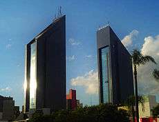
 Downtown Cascavel | |||
| |||
| Motto(s): The Capital of the West | |||
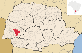 Municipal location | |||
 Cascavel Location in Brazil | |||
| Coordinates: 24°57′20″S 53°27′19″W / 24.95556°S 53.45528°WCoordinates: 24°57′20″S 53°27′19″W / 24.95556°S 53.45528°W | |||
| Country |
| ||
| Region | South | ||
| State | Paraná | ||
| Founded | 1952 | ||
| Government | |||
| • Mayor | Leonaldo Paranhos | ||
| Area | |||
| • Total | 2,100.105 km2 (810.855 sq mi) | ||
| Elevation | 781 m (2,562 ft) | ||
| Population (2016) | |||
| • Total | 316 226 | ||
| Time zone | UTC-3 (UTC-3) | ||
| • Summer (DST) | UTC-2 (UTC-2) | ||
| Postal code | 85816-000 | ||
| Area code(s) | (+55) 45 | ||
| Website | Cascavel | ||

Cascavel is a municipality located in the western region of the state of Paraná, Brazil. It is the 5th most populous city in Paraná with a population of 316,226 inhabitants according to an estimate from IBGE in August 2016. The distance (by freeway) to Curitiba, the state capital, is 491 kilometers.[1]
Relatively new and with a privileged topography, Cascavel's development was planned, which gives it wide streets and well distributed neighborhoods. With an area of 2,100,831 km², it is considered a strategic hub of Mercosul.
The city is on a plateau 781 meters above sea level. It is 504 km west of the state capital of Curitiba and 605 km west of the sea port of Paranaguá, 140 km from the 3 borders (Paraguay, Argentina and Brazil) at 24° 58' South, 53° 26' West.
Toponymy
The name of the city means rattlesnake in Portuguese; it arises from a variation of the classical Latin "caccabus", meaning "bubbling water boiling". According to legend, a group of settlers camped one night in the region and they were woken by the sound of a rattle; later they realized they set up the camp next to a rattlesnake.
History
Cycle of erva mate
The Caingangue natives inhabited western Paraná, which was occupied by the Spaniards in 1557 when they founded the Ciudad del Real Guayrá in current town of Guaíra.
A new occupation started in 1730 with troops ("troperismo" in Portuguese), but the settlement of the current city began in the late 1910s by settlers of mixed racial ethnicity ("caboclos" – people of indigenous and European descent) and descendants of Slavic immigrants, at the peak of the cycle of erva mate.
The village began to form on March 28, 1928, when José Silverio de Oliveira, the "Nho Jeca", leased the land from the settler Jose Antonio Elias, in the historical area of Encruzilhada dos Gomes, and which is currently the Cascavel Velho neighborhood. It was at a junction of several trails open by ervateiros (cultivators of erva mate), drovers and military, where de Oliveira set up his warehouse. His entrepreneurial spirit was key to the arrival of new people, who brought ideas and investments.
From the 1930s and 1940s, thousands of southern settlers, mostly descendants of Poles, Germans, Italians, Ukrainians and caboclos migrating from coffee regions, began logging, farming and raising pigs in the village, which became a district in 1938.
Notably, the locality was already included in military maps from 1924, and the village was made official by the town hall of Iguaçu Falls in 1936, with the name of Cascavel. The bishop of that city, Monsignor William Maria Thiletzek, renamed it as "Aparecida dos Portos", a name that did not work amongst the inhabitants.
Cycle of wood
In the 1930s, with the cycle of erva mate at a close, the surrounding area entered into the so-called "cycle of wood", which attracted a large number of families from Santa Catarina and Rio Grande do Sul. In particular, there were many Polish, German and Italian settlers, who formed the basis of the municipal population.
As the native forests were depleted, the land became available to agriculture sector, which underpins the present-day economy.
In 1938, Cascavel became an administrative district.
Emancipation
The municipality of Cascavel was emancipated on November 14, 1951, by state law n° 790, separating it from Iguaçu Falls.[2] For decades there was a discussion about whether this would be the proper date, as the installation of the first municipal government occurred only on December 14, 1952. However, in 2010, with the law n° 5.689, the discussion was put to rest.[3]
Development
As the cycle of timber closed in the late 1970s, industrialization began along with increased agricultural activity and a rising service industry. In less than six decades, Cascavel went from a rest stop for travelers and trappers, to the largest municipality in western Paraná and one of the largest economic centers in southern Brazil.
List of Mayors
| Name | Terms |
|---|---|
| José Neves Formighieri | December 14, 1952 to December 14, 1956 |
| Helberto Edwino Schwarz | December 14, 1956 to December 14, 1960 |
| Octacílio Mion | December 14, 1960 to December 14, 1964 |
| Odilon Correia Reinhardt | December 14, 1964 to January 31, 1969 |
| Octacílio Mion | January 31, 1969 to January 31, 1973 |
| Pedro Muffato | January 31, 1973 to January 31, 1977 |
| Jacy Miguel Scanagatta | February 1, 1977 to January 31, 1983 |
| Fidelcino Tolentino | February 1, 1983 to December 31, 1988 |
| Salazar Barreiros | January 1, 1989 to December 31, 1992 |
| Fidelcino Tolentino | January 1, 1993 to December 31, 1996 |
| Salazar Barreiros | January 1, 1997 to December 31, 2000 |
| Edgar Bueno | January 1, 2001 to December 31, 2004 |
| Lísias Tomé | January 1, 2005 to December 31, 2008 |
| Edgar Bueno | January 1, 2009 to December 31, 2012 |
| Edgar Bueno | January 1, 2013 to December 31, 2016 |
| Leonaldo Paranhos | January 1, 2017 to December 31, 2020 |
Source: Jornal Hoje[4]
Geography
Climate
Cascavel is located on the Third Plateau ("Terceiro Planalto") in the Western region of the state, with an altitude around 815 meters above sea level and an area of 2,091 km². The weather is sub-tropical, superhumid mesothermal with an average annual temperature around 19 °C. The average maximum temperature in January is 28.6 °C, and in July the average minimum is 11.2 °C, when frost may occur. There are several documented occurrences of snow, from the foundation of the city in 1951 as well as in the years 1957, 1960, 1964, 1975, 1979, 1982, 1984, 1992, 2000, 2006 and 2013. According to the climatic classification of Köppen, Cascavel is located in the Cfb climate region, featuring a mild climate. Within the Cfb climate category, the average temperature in the coldest month should stay below 19 °C (mesothermal), the summers should be fresh (average temperatures in the warmest month must be below 26 °C), and there should not be a dry season. Cascavel is an exception in the Third Plateau because most municipalities in the western region have Cfa climate. This is due to its relatively higher altitude which approaches altitudes of municipalities of the First and Second Plateaus. For example, the elevation of Foz do Iguaçu is just under 200 meters and Curitiba is around 950 meters. The lowest recorded high temperature was on July 17, 1975 when the maximum temperature reached 1.4 °C. The coldest recorded temperature was −6.2 °C on July 18, 1975. The maximum temperature recorded was 35.6 °C on March 12, 2005. Annual average precipitation is 1965 mm (77.362 inches).[5]
Demographics
According to the IBGE, the population of Cascavel is formed of the following ethnicities[6]
| Ethnicity | Percentage |
|---|---|
| White | 70,15% |
| Black | 2,59% |
| Brown | 26,25% |
| Yellow | 0,88% |
| Indigenous | 0,27% |
Evolution of the Population
The County has experienced significant population growth since its foundation, especially during the first decades. On the other hand, several municipalities were ultimately removed from Cascavel, which slightly reduced its demographic expansion.
| Year | Population | Percent Change |
|---|---|---|
| 1950 | 404 inhabitants | |
| 1960 | 39,598 inhabitants | 9.701% |
| 1970 | 89,921 inhabitants | 127,08% |
| 1980 | 163,459 inhabitants | 81,78% |
| 1991 | 192,990 inhabitants | 18,07% |
| 2000 | 245,369 inhabitants | 27,14% |
| 2010 | 286,172 inhabitants | 16,63% |
| 2013 | 305,615 inhabitants | 6,79% * |
- * Variation in the last 3 years according to IBGE estimates.
Economy
Cascavel is responsible for 26% of the total production of cereals in the state of Paraná. The main crops are soybeans, wheat, corn, rice, cotton, and beans. It is also a big producer of poultry, swine, and beef cattle.
Participation in the municipal GDP: Livestock raising: 5.95% Industry: 16.63% Services: 77.42%
The main industries are food processing, chemicals, metallurgy, and beverages.
It is the terminus of a metre-gauge railway line that goes to the port of Paranaguá.
Transportation
The city is served by Adalberto Mendes da Silva Airport.
Universities
Cascavel is also a very important college center. Besides a state university, in recent years the city became an important student hub centre, with an increasing number of private universities starting their activities in the city.[7]
List of universities
- Universidade Estadual do Oeste do Paraná – UNIOESTE
- União Educacional de Cascavel – UNIVEL
- Universidade Paranaense – UNIPAR
- Faculdade Assis Gurgacz – FAG
- Faculdade Missioneira do Paraná – FAMIPAR
- Instituto Tecnológico e Educacional – FACULDADE ITECNE
- Faculdade Anhanguera de Cascavel - ANHANGUERA DE CASCAVEL
References
- ↑ "Indicadores do Portal do Município de Cascavel". 2013. Retrieved May 12, 2013.
- ↑ http://www.legislacao.pr.gov.br/legislacao/pesquisarAto.do?action=exibir&codAto=16495&indice=1&totalRegistros=1
- ↑ Cascavel News
- ↑ Jornal Hoje – Especial Cascavel 55 anos
- ↑ More information about Cascavel's weather in Simepar.
- ↑ IBGE Cidades - Cascavel
- ↑ "Universitários ganham novo espaço para eventos". Portal do Município de Cascavel. Retrieved 7 June 2018.
External links
- Cascavel official website
- Tourist points of Cascavel (in Portuguese)