Pleasant Hill/Contra Costa Centre station
Pleasant Hill / Contra Costa Centre | |||||||||||
|---|---|---|---|---|---|---|---|---|---|---|---|
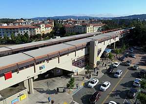 The station viewed from the parking garage in 2018 | |||||||||||
| Location |
1365 Treat Boulevard Walnut Creek, California | ||||||||||
| Coordinates | 37°55′42″N 122°03′22″W / 37.928399°N 122.055992°WCoordinates: 37°55′42″N 122°03′22″W / 37.928399°N 122.055992°W | ||||||||||
| Line(s) | BART C-Line | ||||||||||
| Platforms | 2 side platforms | ||||||||||
| Connections |
| ||||||||||
| Construction | |||||||||||
| Parking | 3011 spaces | ||||||||||
| Bicycle facilities | 90 lockers | ||||||||||
| Disabled access | Yes | ||||||||||
| History | |||||||||||
| Opened | May 21, 1973[1] | ||||||||||
| Traffic | |||||||||||
| Passengers (FY 2016) | 7,433 exits/day[2] | ||||||||||
| Services | |||||||||||
| |||||||||||
Pleasant Hill/Contra Costa Centre is a Bay Area Rapid Transit station serving the Contra Costa Centre Transit Village in Contra Costa Centre, California, just north of Walnut Creek and just east of Pleasant Hill.
History
Service at Pleasant Hill station began on May 21, 1973.[1]
A second parking garage opened at the station on June 30, 2008.[3] The former surface parking lot was converted into the Contra Costa Centre transit village. On September 23, 2010, the BART Board voted to change the station name to Pleasant Hill/Contra Costa Centre.[4] The name change was supposed by the transit village developer and the Contra Costa County Redevelopment Agency, but opposed by the city of Pleasant Hill.[5][6] The Contra Costa County Redevelopment Agency and the developer paid the $413,800 cost of changing station signage and system maps.[6]
An improved access path to the station better connecting it with the Iron Horse Regional Trail was proposed before the Walnut Creek city council on July 15, 2008.[7] The proposal gained support from BART and the local cycling organization.[7] A bridge over Treat Boulevard carrying the Iron Horse Regional Trail was completed on October 2, 2010.[8] The bridge cost $12 million.[9]
Bus connections
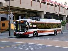
Pleasant Hill/Contra Costa Centre is a transfer point for a number of County Connection local routes:
- Weekday: 7, 9, 11, 14, 15, 18
- Weekend: 311, 316
- Special school route: 619
The station is also served by several longer-distance routes: two Solano Express routes - FAST Blue Line and SolTrans Yellow Line - plus WHEELS route 70X.
All buses stop on a two-way busway on the southwest side of the station.[10]
References
- 1 2 "BART Chronology January 1947 – March 2009" (PDF). San Francisco Bay Area Rapid Transit District. March 2009. Archived from the original (PDF) on October 13, 2013.
- ↑ Bay Area Rapid Transit District. "Monthly Ridership Reports". Retrieved 6 February 2017.
- ↑ "New Garage at Pleasant Hill Station" (Press release). San Francisco Bay Area Rapid Transit District. June 20, 2008.
- ↑ "Board of Directors: Minutes of the 1,608th Meeting: September 23, 2010" (PDF). San Francisco Bay Area Rapid Transit District. September 23, 2010. p. 3.
- ↑ "A Resolution of the City Council of Pleasant Hill Opposing Contra Costa County's Proposal to Rename the Pleasant Hill BART Station". City of Pleasant Hill. October 4, 2010.
- 1 2 White, Lisa P. (September 22, 2010). "Pleasant Hill BART station now 'Pleasant Hill/Contra Costa Centre". East Bay Times.
- 1 2 Pleasant Hill BART Station bike/pedestrian shortcut considered, BART News, July 8, 2008, accessed August 18, 2008
- ↑ East Bay Bicycle Coalition (25 September 2010). "Time to Celebrate! Bike/Ped Bridge over Treat Blvd Opens October 2". East Bay Bicycle Coalition. Retrieved 8 July 2013.
- ↑ Hambrick, Ken (Guest Commentary) (21 August 2010). "Your Turn: Treat Boulevard bridge to nowhere exposes what is wrong with redevelopment". Contra Costa Times. Retrieved 8 July 2013.
- ↑ "Transit Stops: Pleasant Hill Station Area" (PDF). Metropolitan Transportation Commission. June 27, 2018.
External links
| Wikimedia Commons has media related to Pleasant Hill/Contra Costa Centre station. |
| Current lines |
| ||||||||||||
|---|---|---|---|---|---|---|---|---|---|---|---|---|---|
| Stations |
| ||||||||||||
| Infrastructure | |||||||||||||
| History | |||||||||||||
| General Managers |
| ||||||||||||
| Connecting services |
| ||||||||||||
| Other | |||||||||||||