Philippi, Cape Town
| Philippi | |
|---|---|
 Philippi Township | |
 Philippi | |
|
Location within Cape Town  Philippi  Philippi Philippi (South Africa)  Philippi Philippi (Africa) | |
| Coordinates: 34°1′S 18°33′E / 34.017°S 18.550°ECoordinates: 34°1′S 18°33′E / 34.017°S 18.550°E | |
| Country | South Africa |
| Province | Western Cape |
| Municipality | City of Cape Town |
| Area[1] | |
| • Total | 34.21 km2 (13.21 sq mi) |
| Population (2011)[1] | |
| • Total | 6,618 |
| • Density | 190/km2 (500/sq mi) |
| Time zone | UTC+2 (SAST) |
| Postal code (street) | 7750 |
| PO box | 7781 |
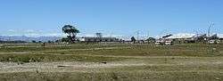
Philippi is one of the larger townships in Cape Town, South Africa. It is sparsely populated compared to the surrounding city and contains many farms.
Philippi is seen by government and businesses as ideal for certain business related developments. Although it is also known to grow about 80% of Cape Town's vegetables in the farmland just outside the township, this area of Philippi is slated for a number of large developments including the 'Philippi Mini-City'.[2][3]
History
The nomadic Khoi and San once used the land for grazing their animals and hunting for food.[4]
The first community of local residents was recorded in 1833 during which time it was known as "Die Duine" (The Dunes).[5]
The Philippi Germans arrived in Cape Town in three groups between 1860 and 1883, and became known for their ability to grow vegetables in the sandy soils of the Cape Flats.[6]
Until the 1970s the area was mainly used for grazing with a few farms located in the area. Rapid residential growth began in the late 1970s and early 1980s as apartheid policies as economic migrants from the former Ciskei and Transkei homelands in the Eastern Cape settled in nearby Nyanga, Langa, Gugulethu, Crossroads, Browns Farm and Samora Machel. As resistance to apartheid grew in the 1980s Philippi increasingly became a place of refuge from the political unrest in the former homelands. Additional residents came to live in Philippi when farms in Mitchell's Plain were eliminated due to urban sprawl.[5]
At least half of Cape Town's vegetables are grown here, despite being surrounded by residential suburbs which include townships, informal settlements and century-old neighourhoods.The ability to grow produce is greatly aided by the fact that the area sits on top of a large aquifer. The Germans developed farming methods over three generations to adapt to the extreme weather conditions and sandy soil. One of these practices was no-till farming. Its use is being reintroduced and encouraged today. [4]
In the Apartheid era it was designated for Coloureds who represent 70.5% with the remainder consisting of Black Africans and whites .
References
- 1 2 "Sub Place Philippi". Census 2011.
- ↑ "The Germans of Philippi". Archived from the original on 2009-10-25.
- ↑ "Cape Town Grows Dynamically".
- 1 2 Sullivan, Helen (2016). "The urban farms that grow half of the vegetables eaten in Cape Town". Retrieved February 12, 2017.
- 1 2 Anderson, Valerie; Azari,Sepideh; van Wyk, Anya (2009). "Philippi Community Profile" (PDF). SAEP. Retrieved January 17, 2013.
- ↑ Annas, Rolf (2014). "Being German in South Africa:Three life stories from the late 19th and early 20th century (citing Lizette Rabe in "Bete und Arbeite", 2010)". Retrieved February 12, 2017.
.svg.png)