Vredehoek
| Vredehoek | |
|---|---|
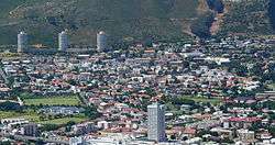 Vredehoek seen from Signal Hill | |
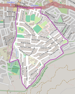 Street map of Vredehoek | |
 Vredehoek | |
|
Location within Cape Town  Vredehoek  Vredehoek Vredehoek (South Africa)  Vredehoek Vredehoek (Africa) | |
| Coordinates: 33°56′15″S 18°25′30″E / 33.93750°S 18.42500°ECoordinates: 33°56′15″S 18°25′30″E / 33.93750°S 18.42500°E | |
| Country | South Africa |
| Province | Western Cape |
| Municipality | City of Cape Town |
| Main Place | Cape Town |
| Area[1] | |
| • Total | 0.94 km2 (0.36 sq mi) |
| Population (2011)[1] | |
| • Total | 3,556 |
| • Density | 3,800/km2 (9,800/sq mi) |
| Racial makeup (2011)[1] | |
| • Black African | 8.8% |
| • Coloured | 5.6% |
| • Indian/Asian | 2.0% |
| • White | 80.4% |
| • Other | 3.2% |
| First languages (2011)[1] | |
| • English | 71.1% |
| • Afrikaans | 18.3% |
| • Other | 10.6% |
| Time zone | UTC+2 (SAST) |
| Postal code (street) | 8001 |
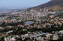
The City Bowl with the suburbs of Devil's Peak Estate, Vredehoek (and the three Disa Park towers in the background), Oranjezicht and The Gardens, with Molteno Dam in the foreground.
Vredehoek (Afrikaans: "corner of peace" or "peace corner"[2]) is a suburb of Cape Town, South Africa located in the City Bowl, on the slopes of Table Mountain, between Devil's Peak Estate and Oranjezicht. The suburb was proclaimed after the first world war and expatriates from many European countries settled here after peace was declared. It is popular among dual income households, yet to have children[2] and the suburb has been going through an urban revival as older blocks of flats are being replaced with high-quality apartments.[2]
External links
References
- 1 2 3 4 "Sub Place Vredehoek". Census 2011.
- 1 2 3 http://www.sa-venues.com/attractionswc/vredehoek.php
.svg.png)
| Wikimedia Commons has media related to Vredehoek. |
This article is issued from
Wikipedia.
The text is licensed under Creative Commons - Attribution - Sharealike.
Additional terms may apply for the media files.