Bonteheuwel
| Bonteheuwel | |
|---|---|
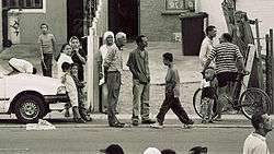 Street scene in Bonteheuwel | |
 Bonteheuwel | |
|
Location within Cape Town  Bonteheuwel  Bonteheuwel Bonteheuwel (South Africa)  Bonteheuwel Bonteheuwel (Africa) | |
| Coordinates: 33°57′04″S 18°33′14″E / 33.951°S 18.554°ECoordinates: 33°57′04″S 18°33′14″E / 33.951°S 18.554°E | |
| Country | South Africa |
| Province | Western Cape |
| Municipality | City of Cape Town |
| Main Place | Athlone |
| Area[1] | |
| • Total | 3.55 km2 (1.37 sq mi) |
| Population (2011)[1] | |
| • Total | 45,967 |
| • Density | 13,000/km2 (34,000/sq mi) |
| Racial makeup (2011)[1] | |
| • Black African | 3.1% |
| • Coloured | 95.3% |
| • Indian/Asian | 0.4% |
| • White | 0.1% |
| • Other | 1.1% |
| First languages (2011)[1] | |
| • Afrikaans | 67.0% |
| • English | 31.4% |
| • Other | 1.6% |
| Time zone | UTC+2 (SAST) |
| PO box | 8925 |
| Area code | 7764 |
Bonteheuwel is a former Coloured township in Cape Town in the Western Cape province of South Africa.
References
- 1 2 3 4 "Sub Place Bonteheuwel". Census 2011.
.svg.png)
This article is issued from
Wikipedia.
The text is licensed under Creative Commons - Attribution - Sharealike.
Additional terms may apply for the media files.