Higgovale, Cape Town
| Higgovale | |
|---|---|
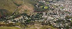 Higgovale as seen from the summit of Table Mountain. | |
 Higgovale | |
|
Location within Cape Town  Higgovale  Higgovale Higgovale (South Africa)  Higgovale Higgovale (Africa) | |
| Coordinates: 33°56′22″S 18°24′09″E / 33.93944°S 18.40250°ECoordinates: 33°56′22″S 18°24′09″E / 33.93944°S 18.40250°E | |
| Country | South Africa |
| Province | Western Cape |
| Municipality | City of Cape Town |
| Time zone | UTC+2 (SAST) |
| Postal code (street) | 8001 |
Higgovale is a small, wealthy community in City Bowl of Cape Town, South Africa.
Geography
Higgovale is situated to the south of Camps Bay Drive and is bordered by the suburb of Camps Bay to the west and Oranjezicht to the east with Lions Head to its immediate north west.
.svg.png)
This article is issued from
Wikipedia.
The text is licensed under Creative Commons - Attribution - Sharealike.
Additional terms may apply for the media files.