Dorian Bay
| Bahia Dorian Refuge | |
|---|---|
| Refuge | |
 Bahia Dorian Refuge | |
 Bahia Dorian Refuge Location of Dorian Bay in Antarctic Peninsula | |
| Coordinates: 64°49′04″S 63°30′15″W / 64.817648°S 63.504133°W | |
| Country |
|
| Location in Antarctica |
Dorian Bay Wiencke Island Antarctica |
| Administered by | Argentine Antarctica |
| Established | 1957 |
| Type | Seasonal |
| Status | Operational |
Dorian Bay (64°49′S 63°30′W / 64.817°S 63.500°WCoordinates: 64°49′S 63°30′W / 64.817°S 63.500°W) is a cove on the northwest side of Wiencke Island, 0.5 nautical miles (1 km) east-northeast of Damoy Point, in the Palmer Archipelago of Antarctica. It was discovered by the French Antarctic Expedition, 1903–05, under Jean-Baptiste Charcot, and named by him after Monsieur Dorian, a member of the French Chamber of Deputies.[1]
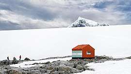
Bahia Dorian Refuge
Two structures were erected on the shores of Dorian Bay; the Argentine Refugio Bahia Dorian in 1957, and a larger building known as the Damoy Hut in 1975, where it served flights to and from a summer-use ice-strip for aircraft used before the sea-ice cleared near Rothera Base. The Damoy hut and ice-strip were closed in 1995: the building is now listed as an Historic Site and Monument and is maintained and administered by the United Kingdom Antarctic Heritage Trust.
See also
References
- ↑ "Dorian Bay". Geographic Names Information System. United States Geological Survey. Retrieved 2012-01-26.
![]()
_Wiencke_Island.jpg)
| General |
| .svg.png) |
|---|---|---|
| Geographic regions | ||
| Waterways | ||
| Famous explorers | ||