Peachtree City, Georgia
| Peachtree City, Georgia | ||
|---|---|---|
 Centennial clubhouse in Peachtree City | ||
| ||
| Nickname(s): The Bubble, PTC | ||
| Motto(s): "Plan to Stay" | ||
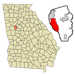 Location in Fayette County and the state of Georgia | ||
 Peachtree City, Georgia Location in the United States | ||
| Coordinates: 33°23′56.37″N 84°34′14.24″W / 33.3989917°N 84.5706222°WCoordinates: 33°23′56.37″N 84°34′14.24″W / 33.3989917°N 84.5706222°W | ||
| Country | United States | |
| State | Georgia | |
| County | Fayette | |
| Government | ||
| • Mayor | Vanessa Fleisch | |
| Area | ||
| • Total | 25.4 sq mi (65.9 km2) | |
| • Land | 24.6 sq mi (63.6 km2) | |
| • Water | 0.9 sq mi (2.4 km2) | |
| Elevation | 899 ft (274 m) | |
| Population (2010) | ||
| • Total | 34,364 | |
| • Estimate (2016)[1] | 35,186 | |
| • Density | 1,400/sq mi (540.7/km2) | |
| Time zone | UTC-5 (Eastern (EST)) | |
| • Summer (DST) | UTC-4 (EDT) | |
| ZIP code | 30269 | |
| Area code(s) | 678, 770, 404 | |
| FIPS code | 13-59724[2] | |
| GNIS feature ID | 0320310[3] | |
| Website |
www | |
Peachtree City is the largest city in Fayette County, Georgia, United States. As of the 2016 United States Census it had a population of 35,186.[4] Peachtree City is located in South Metro Atlanta.
Geography
Peachtree City is located in western Fayette County in the southern Atlanta metro area. It is bordered to the west by Coweta County and to the north by the city of Tyrone. It is crossed by Georgia State Route 74, Georgia State Route 34, and Georgia State Route 54. SR 54 leads east 10 miles (16 km) to Fayetteville, the county seat, and southwest 17 miles (27 km) to Luthersville. Newnan is 12 miles (19 km) to the west via SR 54 and SR 34. SR 74, the Joel Cowan Parkway, runs through the west side of Peachtree City, leading north 6 miles (10 km) to Tyrone and 11 miles (18 km) to Interstate 85 near Fairburn. Downtown Atlanta is 31 miles (50 km) to the north via SR 74 and I-85.
According to the U.S. Census Bureau, Peachtree City has a total area of 25.4 square miles (65.9 km2), of which 24.6 square miles (63.6 km2) is land and 0.93 square miles (2.4 km2), or 3.57%, is water.[2] The city is in the watershed of Line Creek, which forms the western city boundary and county line, and is a south-flowing tributary of the Flint River.
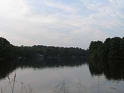
Peachtree City has three lakes. Lake Kedron to the north is a reservoir that supplies Lake Peachtree to the south via Flat Creek. Lake Kedron is owned by the Fayette County Authority, and is managed so as to keep Lake Peachtree full whenever there is a lack of rain and still allow for recreational use of the lake during droughts. Lake Kedron is not afforded any recreational use except for fishing. Lake McIntosh, the newest lake, close to Planterra, has now reached full pool.[5]
Shakerag Hill, with an elevation of 980 feet (300 m), is the highest point in the city and sits on the eastern border at the intersection of GA Hwy 54 and Robinson Road.
Peachtree City has a system of golf cart paths which spider across the town and provide a secondary means of access to almost any destination within city limits. These multi-use paths stretch for more than 90 miles (140 km) throughout the city. Many places of business have specially designated golf cart parking spaces. The Peachtree City Police Department has several golf carts used to patrol along these paths.[6]
Over 9,000 households own a golf cart, and use them as an extra vehicle for local transportation. Children aged twelve or over may operate a cart on Peachtree City cart paths with a parent, grandparent or guardian in the front seat. Unaccompanied fifteen-year-olds with valid Georgia learner's permits are allowed to operate golf carts alone. Students at McIntosh High School are encouraged to drive family golf carts to school because of limited car parking. In 2015, Starr's Mill High School opened a golf-cart specific lot. The golf cart paths are used also by cyclists, joggers, and pedestrians as a safer alternative to the side of the road. In February 2003, Golf Digest magazine discussed the traffic congestion caused by use of golf carts in the city.[7]
Airports
Atlanta Regional Airport, also known as Falcon Field, is a general aviation airport that provides chartered air service. Since 1987, it has grown from having about 60 aircraft based at the airport to about 165. The runway is 5,220 feet (1,590 m) long and holds up to 60,000 pounds (27,000 kg) of aircraft. It mainly serves Peachtree City's business residents, but also serves as a place of entertainment for people interested. There is a viewing area provided for the public to watch aircraft take-off and land. The airport hosts many events throughout the year, including the Great Georgia Air Show. The airport is the location of a National Weather Service radar station, Southeast River Forecast Center,[8] and Weather Forecast Office,[9] which serves 96 counties in northern and central Georgia.
Hartsfield-Jackson Atlanta International Airport provides commercial service and is located 25 miles (40 km) northeast of Peachtree City via Georgia State Route 74 and Interstate 85.
Peachtree City was designated a foreign-trade zone by the U.S. Customs Service. In the U.S., a foreign-trade zone is a site in or near a U.S. Customs port of entry (in this case Hartsfield–Jackson Atlanta International Airport), designated free of customs entry procedures.
History
Timeline:
- In 1957, Flat Creek was dammed to create Lake Peachtree.[10]
- In 1965, the Peachtree City volunteer fire department was created. The one-car Peachtree City police department was created as well.
- In 1968, Falcon Field airport was founded by Joel Cowan as Peachtree City-Falcon Field. Peachtree City Elementary School opened as well.
- In 1972, Peachtree City was granted its own ZIP code (30269).
- In 1974, the Peachtree City Public Library opened. The Georgia state legislature passed legislation permitting golf carts to be operated on city streets.
- In 1975, Peachtree City was named "one of America's best suburbs" by Ladies' Home Journal magazine.
- In 1976, Peachtree City got its own telephone exchange (487). Residents then had to dial "8" to reach Atlanta, which remained the case until digital equipment was installed in 1988.
- In 1976, Frederick Brown Jr. Amphitheater (then known as the Peachtree City Amphitheater) was built as a Bicentennial project and opened to the public with the production "The MacIntosh Trail", which told the story of Creek Chief William McIntosh and the Trail of Tears. (It was intended as a tourist attraction similar to the Cherokee, North Carolina, production of Unto These Hills.) When further funding was not forthcoming the project went into foreclosure. Peachtree City purchased the amphitheater at the courthouse steps in 1977.
- In 1979, the first traffic light within city limits was installed at the intersection of Georgia State Route 54 and Georgia State Route 74.
- In 1981, McIntosh High School opened.
- In 1983, Peachtree City held a free music festival to celebrate the opening of several new shops and stores, including the Galaxy Games arcade. Several local bands played at the free event, including "Alliance".
- In 1984, Hoshizaki America, Inc. builds corporate headquarters, warehousing and manufacturing facility in Peachtree City
- In 1992, Peachtree City altered the length of the mayoral and council members' terms of office from two to four years. Term limits were enacted to restrict both mayor and council members to a maximum of two four-year terms.
- In 1994, the first Summer Concert Series premiered at Frederick Brown, Jr. Amphitheater on June 17, 1994, to a sold-out audience. The first concert featured Three Dog Night.
- In 1994, the National Weather Service central office relocated from Hartsfield–Jackson Atlanta International Airport.
- In 1994, Fuller Life Chiropractic Center opened its initial office.
- In 1996, the Olympic flame passed through on its way to Atlanta.
- In 2001, the city was designated a "Tree City USA" by the Arbor Day Foundation.[11]
- In 2002, Peachtree City (specifically Starr's Mill) was a filming location for the movie Sweet Home Alabama.
- In 2007, the city announced a plan to formally annex an unincorporated area between Georgia State Route 74 and the border with Coweta County that is commonly referred to as "The West Village", or "Wilksmoor Village".
- In 2013, the 650-acre Lake McIntosh opened for public use
Rankings
In July 2005, CNN/Money and Money magazine ranked Peachtree City eighth on its list of the "100 Best Places to Live in the United States".[12] In July 2007, in the same award, the city was ranked 64th.[13] In July 2009, Peachtree City was ranked eighth on the list.[14] In August 2011, Peachtree City ranked 91st on the list.[15]
In 2011, the city was ranked in the top 25 cities to relocate to by Relocate America.
Peachtree City was ranked number one for "Best Places to Raise Kids" in the state of Georgia, according to Bloomberg Business Week (December 2012).[16]
In 2017, Peachtree City was ranked as the safest city in Georgia, among the top 5th percentile safest cities in America, based on the FBI crime data.<https://www.safehome.org/safest-cities/ga/>
Economy
- Eaton Corp - Lighting Division formerly Cooper Industriesis headquartered in Peachtree City.
- Hoshizaki America, Inc. has its corporate headquarters and a warehousing and manufacturing facility in Peachtree City and employs over 700 people throughout the United States. It is a major supplier of Ice Machines /icemakers, Refrigerated Display Cases, Dispensers, Prep Tables, Commercial Refrigerators and Freezer for foodservice, hotels, restaurants, hospitals & nursing homes, schools and convenience stores.[17]
- Panasonic Automotive Systems Company of America (PASA) has its main operations based in Peachtree City and is the largest employer in the city. It is a major supplier of automotive audio, video and navigation systems for Honda (including its Acura luxury division), Ford (Sync 3), Nissan, General Motors, Toyota and Subaru.
Other large employers in Peachtree City's industrial park include:[18]
- Sany, a Chinese multinational heavy machinery manufacturer[19]
- TDK Corporation, a media storage device manufacturer[20]
- Avery Dennison, a paper product company that manufactures decals and other adhesives
- NCR Corporation, formerly National Cash Register, a company that manufactures ATMs (ABM, computers and software
In addition to working within the city, many Peachtree Citians commute to Atlanta. Airlines, such as Delta, United, and Southwest, are major employers.
Peachtree City is the city of license for WRDG (96.7 FM), an alternative rock radio station.
Government
As of January 2014, the mayor of Peachtree City is Vanessa Fleisch. Council members include Kim Learnard, Eric Imker, Terry Ernst, and Mike King.
Fleisch is the first female mayor in the city's history.
Climate
| Climate data for Peachtree City, Georgia | |||||||||||||
|---|---|---|---|---|---|---|---|---|---|---|---|---|---|
| Month | Jan | Feb | Mar | Apr | May | Jun | Jul | Aug | Sep | Oct | Nov | Dec | Year |
| Record high °F (°C) | 80 (27) |
82 (28) |
87 (31) |
92 (33) |
97 (36) |
101 (38) |
104 (40) |
102 (39) |
99 (37) |
97 (36) |
88 (31) |
79 (26) |
104 (40) |
| Average high °F (°C) | 55 (13) |
59 (15) |
67 (19) |
75 (24) |
81 (27) |
88 (31) |
90 (32) |
89 (32) |
84 (29) |
75 (24) |
66 (19) |
57 (14) |
74 (23) |
| Average low °F (°C) | 30 (−1) |
33 (1) |
39 (4) |
46 (8) |
55 (13) |
64 (18) |
68 (20) |
67 (19) |
60 (16) |
49 (9) |
40 (4) |
32 (0) |
49 (9) |
| Record low °F (°C) | −8 (−22) |
4 (−16) |
11 (−12) |
24 (−4) |
35 (2) |
41 (5) |
50 (10) |
51 (11) |
32 (0) |
25 (−4) |
4 (−16) |
−2 (−19) |
−8 (−22) |
| Average precipitation inches (mm) | 4.58 (116.3) |
5.07 (128.8) |
5.09 (129.3) |
3.83 (97.3) |
3.92 (99.6) |
3.80 (96.5) |
4.95 (125.7) |
4.46 (113.3) |
3.76 (95.5) |
3.25 (82.6) |
4.15 (105.4) |
4.21 (106.9) |
51.07 (1,297.2) |
| Source: [21] | |||||||||||||
Demography
| Historical population | |||
|---|---|---|---|
| Census | Pop. | %± | |
| 1970 | 793 | — | |
| 1980 | 6,429 | 710.7% | |
| 1990 | 19,027 | 196.0% | |
| 2000 | 31,580 | 66.0% | |
| 2010 | 34,364 | 8.8% | |
| Est. 2016 | 35,186 | [1] | 2.4% |
| U.S. Decennial Census[22] | |||
As of the 2000 census,[23] there were 31,580 people, 10,876 households, and 8,874 families residing in the city. The population density was 1,321.3 inhabitants per square mile (510.2/km2). There were 11,313 housing units at an average density of 486.1 per square mile (187.7/km2). The racial makeup of the city was 89.66% White, 4.11% African American, 0.16% Native American, 3.70% Asian, 0.03% Pacific Islander, 0.92% from other races, and 1.43% from two or more races. Hispanic or Latino of any race were 3.75% of the population.
There were 10,876 households out of which 47.1% had children under the age of 18 living with them, 70.8% were married couples living together, 8.4% had a female householder with no husband present, and 18.4% were non-families. 16.0% of all households were made up of individuals and 5.7% had someone living alone who was 65 years of age or older. The average household size was 2.89 and the average family size was 3.25.
In the city, the population was spread out with 31.6% under the age of 18, 5.8% from 18 to 24, 28.5% from 25 to 44, 26.2% from 45 to 64, and 8.0% who were 65 years of age or older. The median age was 38 years. For every 100 females, there were 95.2 males. For every 100 females age 18 and over, there were 90.7 males.
According to a 2007 estimate, the median income for a household in the city was $84,339, and the median income for a family was $96,880.[24]
Education
Primary and secondary schools
Peachtree City is served by the Fayette County School System.
Elementary schools that serve the city include:
- Peeples Elementary School (Unincorporated Fayette County)
- Braelinn Elementary School (Peachtree City)
- Huddleston Elementary School (Peachtree City)
- Kedron Elementary School (Peachtree City)
- Oak Grove Elementary School (Peachtree City)
- Peachtree City Elementary School (Peachtree City)
- Crabapple Lane Elementary School (Peachtree City)
Middle schools that serve the city include:
- J.C. Booth Middle School (Peachtree City) - serves central and northern Peachtree City
- Rising Starr Middle School (Unincorporated Fayette County) - serves southern Peachtree City
High schools that serve the city include:
- McIntosh High School (Peachtree City) - serves central and northern Peachtree City
- Starr's Mill High School (Unincorporated Fayette County) - serves southern Peachtree City
- Whitewater High School - serves some of southeastern Peachtree City)
Private and non-traditional schools include:
- Our Lady of Victory Catholic School (Grades K-8) - elementary and middle school located in Tyrone
- Our Lady of Mercy Catholic High School - located in Fayetteville
- The Campus (Grades 1-12)
- Trinity Christian School (grades 1-12) - grades 1-8 are at the main campus; high school is at the old Crossroads Church
- Landmark Christian School (Grades 1-5) - this is an elementary campus; main campus is located in Fairburn, serving grades K4-12
- St. Paul Lutheran School (grades pre-K-8) - elementary and middle school, located inside Peachtree City at the intersection of Georgia Highway 74 and Ardenlee Drive
Colleges and universities
Universities that serve the city include:
- Clayton State University - This facility is at the north end of Peachtree Pkwy in Peachtree City. It offers dual-credit enrollment program for high school students. Fayette has an instructional site with undergraduate degrees in business, psychology, integrative studies, administrative management, and technology management, and an MBA program with a concentration in logistics and supply chain management.
- Point University (Former Atlanta Christian College) - This campus offers the Access program for adult learners and the dual-credit enrollment program for high school students.
Film and television
Lifetime's Drop Dead Diva was filmed in Peachtree City and surrounding areas of Fayette and Coweta County.[26] With Raleigh Studios in nearby Senoia, Peachtree City has often been the backdrop for episodes of other series, such as The Walking Dead.[27] Scenes from the film Joyful Noise were shot there as well.[28]
Recreation
Peachtree City has several golf and country clubs.
Flat Creek Country Club offers 27 holes of golf. Designed by Joe Lee and opened in 1968, the course features three diverse nines, a variety of elevation changes, and views of the Flat Creek, which meanders throughout the course. Flat Creek also has a pool and tennis facility. The clubhouse offers both indoor and outdoor dining options including three separate dining rooms that can be combined, and a bar area with flat-screen TVs.
Braelinn Golf Club is a collaboration by architects Joe Lee and Rocky Roquemore, and opened in 1988. The 18-hole layout includes a mix of holes with tree-lined fairways, challenging water features and numerous bunkers. Members also enjoy swimming, tennis and dining facilities on site. The elegant clubhouse includes a pro shop, locker rooms and a grill-style restaurant overlooking the driving range.
Planterra Ridge Golf Club is a popular Jeff Burton and Rocky Roquemore design that was opened in 1994. Players of all ages and expertise enjoy 18 holes of greens and tree-lined fairways. Tennis, swimming and a variety of events enhance life at the club. The clubhouse sits above the course, with views of the finishing holes and practice green, a pro shop, locker rooms and a dining venue that offers both walk-up and sit-down service.
All three are owned by Clubcorp, which owns or operates an exclusive private club portfolio of more than 200 golf and country clubs, business clubs, sports clubs and alumni clubs in 26 states, the District of Columbia and two foreign countries. These clubs were formerly owned by Sequoia Golf, before Clubcorp purchased Sequoia in 2014.
Sports
Soccer
On January 8, 2016, the Premier Development League awarded a soccer franchise to Peachtree City. The Peachtree City MOBA football club's inaugural season was the 2016 season. The team is owned by Volker Harms, the owner of the state-of-the-art MOBA Soccer Academy in Peachtree City, and managed by former professional footballer Omar Jarun. The club plays out of MOBA Soccer Stadium at MOBA Soccer Academy.[29]
Notable People
- Reed Sorenson, NASCAR driver
- Kelley O'Hara, USWNT player
References
- 1 2 "Population and Housing Unit Estimates". Retrieved June 9, 2017.
- 1 2 "Geographic Identifiers: 2010 Census Summary File 1 (G001), Peachtree City city, Georgia". American FactFinder. U.S. Census Bureau. Retrieved April 27, 2016.
- ↑ "US Board on Geographic Names". United States Geological Survey. 2007-10-25. Retrieved 2008-01-31.
- ↑ "U.S. Census Bureau QuickFacts: Peachtree City city, Georgia". Census Bureau QuickFacts. Retrieved July 11, 2018.
- ↑ "Archived copy". Archived from the original on February 7, 2013. Retrieved February 17, 2013.
- ↑ "Peachtree City, GA - Official Website - Paths & Golf Carts." Peachtree City, GA - Official Website. Web. 23 Aug. 2010. <http://www.peachtree-city.org/index.aspx?nid=216>.
- ↑ Kapriske, Ron. "Golf Cart Gridlock". Golf Digest (February 2003)
- ↑ "Southeast RFC". Weather.gov. Retrieved July 11, 2018.
- ↑ "Peachtree City, GA". Weather.gov. Retrieved July 11, 2018.
- ↑ "Lake Peachtree". EventSeeker. Retrieved April 2, 2013.
- ↑ Munford, John (March 7, 2001). "PTC ready to celebrate Tree City USA honor". The Citizen (Fayetteville). Citizen Newspapers. Archived from the original on July 16, 2011. Retrieved April 10, 2009.
- ↑ "Best Places To Live - 8. Peachtree City, Ga". Money magazine. Time, Inc. July 2005. Retrieved April 10, 2009{{inconsistent citations}}
- ↑ Ashford, Kate; Bartz, Andrea; Cox, Jeff; Fitch, Asa; Gandel, Stephen; Hyatt, Josh; Kelley, Rob; Knight, Kathleen; Light, Joe (July 2007). "Best Places To Live - 64. Peachtree City, Ga". Money magazine. Time, Inc. Retrieved April 10, 2009{{inconsistent citations}}
- ↑ "Best Places To Live - 8. Peachtree City, Ga". Money magazine. Time, Inc. July 2009. Retrieved July 13, 2009{{inconsistent citations}}
- ↑ "Best Places To Live - 91. Peachtree City, Ga". Money magazine. Time, Inc. July 2011. Retrieved August 15, 2011{{inconsistent citations}}
- ↑ "Best Places to Raise Kids". Bloomberg Businessweek.
- ↑ "Hoshizaki America Inc." Retrieved October 22, 2011.
- ↑ "Peachtree City, GA - Official Website - Relocating to PTC". Peachtree-city.org.
- ↑ "China's Sany: From Hunan Home to Peachtree City". Global Atlanta. Archived from the original on March 31, 2012. Retrieved February 28, 2012.
- ↑ "TDK Companies in the Americas". TDK official website. Retrieved May 2, 2010.
- ↑ "Monthly Averages for Peachtree City, GA (30269)". Weather.com. Retrieved March 19, 2012.
- ↑ "Census of Population and Housing". Census.gov. Archived from the original on May 12, 2015. Retrieved June 4, 2015.
- ↑ "Profile of General Demographic Characteristics: 2000 Census Summary File 1 (SF 1) 100-Percent Data, Peachtree City city, Georgia". American FactFinder. U.S. Census Bureau. Retrieved April 27, 2016.
- ↑ "Fact Sheet - Peachtree City city (sic), Georgia". United States Census Bureau. 2005–2007. Retrieved April 9, 2009{{inconsistent citations}}
- ↑ Home. Phi Mu. Retrieved July 1, 2010. "National Headquarters 400 Westpark Drive Peachtree City, GA 30269."
- ↑ "Drop Dead Diva". Peachtree City. Archived from the original on December 5, 2011. Retrieved August 27, 2012.
- ↑ Boylan, Michael (1 June 2011). "PTC on zombie alert". The Citizen. Retrieved August 27, 2012.
- ↑ "'Joyful Noise' filming comes to Peachtree City" Archived May 18, 2011, at the Wayback Machine., March 15, 2011, Michael Boylan, The Citizen
- ↑
Other sources
- "Welcome to Peachtree City-Falcon Field!" Peachtree City official website, October 11, 2008
- "Peachtree City Falcon Field - Peachtree City, GA" Waymark, October 11, 2008
- Aventure Aviation "Aventure Aviation Named Exporter of the Year" Hardin, April 10, 2009
External links
| Wikimedia Commons has media related to Peachtree City, Georgia. |
- Peachtree City official website
- Peachtree City Fire Department
- National Weather Service Forecast Office, Peachtree City, Georgia
- Fayette County Development Authority
- [http://www.peachtree-city.org/index.asp?nid=434 West Village annexation announcement]
- Peachtree City citizen forum
- Holly Grove African Methodist Episcopal Church historical marker
Municipalities and communities of Fayette County, Georgia, United States | ||
|---|---|---|
| Cities | 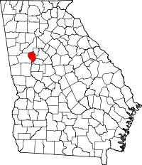 | |
| Towns | ||
| Unincorporated community | ||
|  | |||||
|
| ||||||
| ||||||