Fairburn, Georgia
| Fairburn, Georgia | |
|---|---|
| City | |
 Downtown Fairburn | |
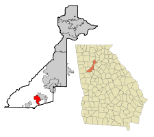 Location in Fulton County and the state of Georgia | |
 Fairburn Location in Fulton County and the state of Georgia | |
| Coordinates: 33°33′45″N 84°34′53″W / 33.56250°N 84.58139°WCoordinates: 33°33′45″N 84°34′53″W / 33.56250°N 84.58139°W | |
| Country | United States |
| State | Georgia |
| County | Fulton |
| Government | |
| • Type | Mayor–council government |
| • Mayor | Elizabeth Carr-Hurst[1] |
| • City Administrator | Tom Barber |
| Area | |
| • Total | 17.1 sq mi (44.2 km2) |
| • Land | 16.9 sq mi (43.6 km2) |
| • Water | 0.2 sq mi (0.5 km2) |
| Elevation | 1,027 ft (313 m) |
| Population (2010) | |
| • Total | 12,950 |
| • Estimate (2016)[2] | 14,182 |
| • Density | 760/sq mi (290/km2) |
| • Demonym | Firburnite |
| Time zone | UTC-5 (Eastern (EST)) |
| • Summer (DST) | UTC-4 (EDT) |
| ZIP code | 30213 |
| Area code(s) | 770 |
| FIPS code | 13-28380[3] |
| GNIS feature ID | 0314030[4] |
| Website | Fairburn, GA |
Fairburn is a city and former county seat in Fulton County, Georgia, United States. The population was 12,950 at the 2010 census.[5]
History
Fairburn is located along a railroad line and was the county seat of Campbell County starting in 1871. It was chosen as county seat in a referendum in 1871 that was spurred by the original seat of Campbellton refusing to allow the Atlanta & West Point Railroad line through on account of the anticipated noise in the 1850s. The railroad instead passed through Fairburn. Campbellton then faded away as Fairburn grew. The government of Campbell County went bankrupt in 1931 during the Great Depression and, along with Milton County to the north, was absorbed into Fulton County when 1932 began.
Geography
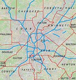
Fairburn is located at 33°33′45″N 84°34′53″W / 33.56250°N 84.58139°W (33.562411, -84.581443).[7] Fairburn is located along Interstate 85, which leads northeast 20 miles (32 km) to downtown Atlanta and southwest 142 miles (229 km) to Montgomery, Alabama. Georgia State Route 74 also runs through the city, leading south 13 miles (21 km) to Peachtree City.
According to the 2010 census, the city has a total area of 17.1 square miles (44.3 km2), of which 16.9 square miles (43.8 km2) is land and 0.2 square miles (0.5 km2), or 1.24%, is water.[8]
Demographics
| Historical population | |||
|---|---|---|---|
| Census | Pop. | %± | |
| 1860 | 298 | — | |
| 1870 | 305 | 2.3% | |
| 1880 | 563 | 84.6% | |
| 1890 | 695 | 23.4% | |
| 1900 | 761 | 9.5% | |
| 1910 | 1,395 | 83.3% | |
| 1920 | 1,600 | 14.7% | |
| 1930 | 1,372 | −14.2% | |
| 1940 | 1,502 | 9.5% | |
| 1950 | 1,889 | 25.8% | |
| 1960 | 2,470 | 30.8% | |
| 1970 | 3,143 | 27.2% | |
| 1980 | 3,466 | 10.3% | |
| 1990 | 4,013 | 15.8% | |
| 2000 | 5,464 | 36.2% | |
| 2010 | 12,950 | 137.0% | |
| Est. 2016 | 14,182 | [2] | 9.5% |
| U.S. Decennial Census[9] | |||
As of the census[3] of 2000, there were 5,464 people, 1,879 households, and 1,416 families residing in the city. The population density was 750.9 people per square mile (289.8/km²). There were 2,005 housing units at an average density of 275.5 per square mile (106.3/km²). The racial makeup of the city was 47.64% African American, 43.08% White, 0.29% Native American, 0.71% Asian, 6.46% from other races, and 1.81% from two or more races. Hispanic or Latino of any race were 13.01% of the population.
There were 1,879 households out of which 37.1% had children under the age of 18 living with them, 51.0% were married couples living together, 18.4% had a female householder with no husband present, and 24.6% were non-families. 19.7% of all households were made up of individuals and 7.0% had someone living alone who was 65 years of age or older. The average household size was 2.85 and the average family size was 3.26.
In the city, the population was spread out with 27.3% under the age of 18, 10.1% from 18 to 24, 30.7% from 25 to 44, 20.6% from 45 to 64, and 11.5% who were 65 years of age or older. The median age was 33 years. For every 100 females, there were 94.8 males. For every 100 females age 18 and over, there were 92.0 males.
The median income for a household in the city was $39,679, and the median income for a family was $42,219. Males had a median income of $32,708 versus $28,940 for females. The per capita income for the city was $18,898. About 6.1% of families and 7.7% of the population were below the poverty line, including 11.9% of those under age 18 and 2.8% of those age 65 or over.
Education
- Fulton County Schools serves Fairburn.
- Arlington Christian School is a private school in Fairburn.
- Atlanta-Fulton Public Library System operates the Fairburn Branch.[10]
- Landmark Christian School is a private school in Fairburn.
- The Bedford School is a private school in Fairburn.
- Georgia Military College has a campus located in Fairburn, offering associate degrees.
- Brenau University has a satellite campus in Fairburn.
- The University of Georgia at Fairburn is home to the Pandas.
Culture
Fairburn is home to the Georgia Renaissance Festival, in operation during the springtime.
| Wikimedia Commons has media related to Fairburn, Georgia. |
References
- ↑ Fairburn official web site. Retrieved September 29, 2018.
- 1 2 "Population and Housing Unit Estimates". Retrieved June 9, 2017.
- 1 2 "American FactFinder". United States Census Bureau. Retrieved 2008-01-31.
- ↑ "US Board on Geographic Names". United States Geological Survey. 2007-10-25. Retrieved 2008-01-31.
- ↑ "Race, Hispanic or Latino, Age, and Housing Occupancy: 2010 Census Redistricting Data (Public Law 94-171) Summary File (QT-PL), Fairburn city, Georgia". U.S. Census Bureau, American FactFinder 2. Archived from the original on September 11, 2013. Retrieved October 28, 2011.
- ↑ Krakow, Kenneth K. (1975). Georgia Place-Names: Their History and Origins (PDF). Macon, GA: Winship Press. p. 76. ISBN 0-915430-00-2.
- ↑ "US Gazetteer files: 2010, 2000, and 1990". United States Census Bureau. 2011-02-12. Retrieved 2011-04-23.
- ↑ "Geographic Identifiers: 2010 Demographic Profile Data (G001), Fairburn city, Georgia". U.S. Census Bureau, American FactFinder 2. Archived from the original on September 11, 2013. Retrieved October 28, 2011.
- ↑ "Census of Population and Housing". Census.gov. Archived from the original on May 12, 2015. Retrieved June 4, 2015.
- ↑ "Fairburn Branch." Atlanta-Fulton Public Library System. Retrieved on February 24, 2010.
Municipalities and communities of Fulton County, Georgia, United States | ||
|---|---|---|
| Cities | 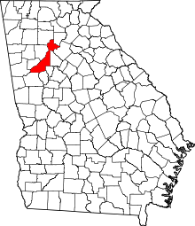 | |
| Unincorporated communities | ||
| Footnotes | ‡This populated place also has portions in an adjacent county or counties | |
|  | |||||
|
| ||||||
| ||||||