Tarrafal de Monte Trigo
| Tarrafal de Monte Trigo | |
|---|---|
 | |
 | |
| Coordinates: 16°57′32″N 25°18′36″W / 16.959°N 25.310°WCoordinates: 16°57′32″N 25°18′36″W / 16.959°N 25.310°W | |
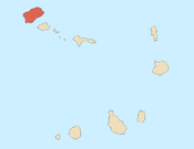
| Country | Cape Verde |
| Island | Santo Antão |
| Municipality | Porto Novo |
| Civil parish | São João Baptista |
| Population (2010)[1] | |
| • Total | 841 |
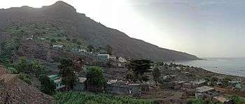
Tarrafal de Monte Trigo is a settlement in the southwestern part of the island of Santo Antão, Cape Verde. In 2010 its population was 841. It is situated on the coast, 27 km west of the island capital Porto Novo. The settlement was mentioned as Terrafal in the 1747 map by Jacques-Nicolas Bellin.[2]
.JPG)
The dirt road connecting Tarrafal with Porto Novo
See also
References
- ↑ "2010 Census results". Instituto Nacional de Estatística Cabo Verde (in Portuguese). 24 November 2016.
- ↑ Jacques-Nicolas Bellin (1747). "Carte des Isles du Cap Verd = Kaart van de Eilanden van Kabo Verde" (in French).
External links
Subdivisions of the island of Santo Antão | |||||||||
|---|---|---|---|---|---|---|---|---|---|
| Paul |
|  | |||||||
| Porto Novo |
| ||||||||
| Ribeira Grande |
| ||||||||
This article is issued from
Wikipedia.
The text is licensed under Creative Commons - Attribution - Sharealike.
Additional terms may apply for the media files.