Panasesa Island
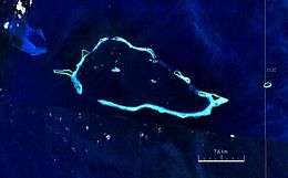 Satellite image of Conflict Group atoll. | |
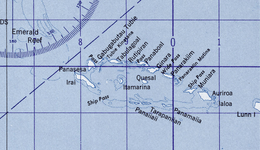 Panasesa Island on Conflict Group atoll map. | |
 Panasesa Island Location of the Panasesa Island | |
| Geography | |
|---|---|
| Location | Oceania |
| Coordinates | 10°44′22.5″S 151°43′26.8″E / 10.739583°S 151.724111°ECoordinates: 10°44′22.5″S 151°43′26.8″E / 10.739583°S 151.724111°E |
| Archipelago | Louisiade Archipelago |
| Adjacent bodies of water | Solomon Sea |
| Total islands | 1 |
| Area | 0.66 km2 (0.25 sq mi) |
| Length | 1.2 km (0.75 mi) |
| Width | 1 km (0.6 mi) |
| Highest elevation | 8 m (26 ft) |
| Highest point | 18 |
| Administration | |
| Province |
|
| District | Samarai-Murua District |
| LLG | Bwanabwana Rural LLG |
| Island Group | Calvados Chain |
| Largest settlement | Irai (pop. 20) |
| Additional information | |
| Time zone | |
| ISO code | PG-MBA |
| Official website |
www |
Panasesa Island is located in Milne Bay Province, Papua New Guinea, 500 km to the east of Port Moresby, the nation's capital. Panasesa Island has an eco resort with small staff.[1]
Geography
Panasesa Island is part of Conflict Group atoll in Louisiade Archipelago.[2] It is situated just north of larger Irai Island. The land of Island is flat. The highest point on the island is 18 meters above sea level. It covers about 1.2 km from the north to the south and 1.0 km from the east to the west.
Due to island location tropical weather prevails.[3]
References
- ↑ John Huxley What it’s like touring rich-lister Ian Gowrie-Smith’s private paradise, the Conflict Islands in PNG Escape, June 29, 2014
- ↑ Prostar Sailing Directions 2004 New Guinea Enroute, p. 168
- ↑ Panasesa Island, Milne Bay (Papua New Guinea) Norwegian Meteorological Institute and Norwegian Broadcasting Corporation 2007 - 2018
This article is issued from
Wikipedia.
The text is licensed under Creative Commons - Attribution - Sharealike.
Additional terms may apply for the media files.