Tagula Island
| Nickname: Sudest Island / Tagula Island | |
|---|---|
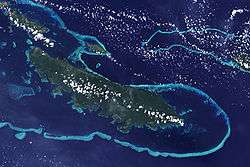 Tagula Island as seen from space. Yeina Island is also visible to the north (top). | |
 Vanatinai Island | |
| Geography | |
| Location | Oceania |
| Coordinates | 11°30′S 153°26′E / 11.500°S 153.433°ECoordinates: 11°30′S 153°26′E / 11.500°S 153.433°E[1] |
| Archipelago | Louisiade Archipelago |
| Adjacent bodies of water | Solomon Sea |
| Total islands | 1 |
| Major islands |
|
| Area | 830 km2 (320 sq mi) |
| Length | 63 km (39.1 mi) |
| Width | 13 km (8.1 mi) |
| Highest elevation | 806 m (2,644 ft) |
| Highest point | Mount Riu |
| Administration | |
| Province |
|
| District | Samarai-Murua District |
| LLG [2] | Yaleyamba Rural Local Level Government Area |
| Island Group | Vanatinai Islands |
| Largest settlement | Rambuso (pop. ~500) |
| Demographics | |
| Population | 3628 (2014) |
| Pop. density | 4.37 /km2 (11.32 /sq mi) |
| Ethnic groups | Papauans, Austronesians, Melanesians. |
| Additional information | |
| Time zone | |
| ISO code | PG-MBA |
| Official website |
www |
Vanatinai Island (also called Tagula and Sudest, for the names of the extreme capes of the island) is a volcanic island in the south-east of the Louisiade Archipelago within Milne Bay Province of Papua New Guinea. The reef fringed island is approximately 360 kilometres (224 miles) south-east of New Guinea and 30 kilometres (19 miles) south of Misima. With an area of 830 square kilometres (320.5 square miles), it is the largest island of the archipelago. Tagula town, the main settlement, is located on the north-west coast. The population was 3628 as of 2014. The principal export is copra.
Geography
The island is 63 kilometres (39 miles) long, stretching from Cape Tagula to Cape Sudest, and up to 13 km (8.1 miles) wide. A wooded mountain range runs through the length of the island, with the summit, Mount Riu (806 metres or 2,644 feet) near the center. The most important peaks of the range are, from west to east:
- Mount Madau (269 metres or 883 feet)
- Mount Gangulua (439 metres or 1,440 feet)
- Mount Riu (formerly called Mount Rattlesnake) (806 metres or 2,644 feet)
- Mount Imau (485 metres or 1,591 feet)
- Mount Arumbi (350 metres or 1,150 feet)
History
The first recorded sighting by Europeans of Vanatinai Island was by the Spanish expedition of Luís Vaez de Torres on 14 July 1606.[3][4][5]
The island was the site of a gold rush that peaked in 1889. Gold was found in nearly all of the island's water courses.[6]
Rambuso Village is located on the north coast of the eastern part of the island, where Rambuso Creek flows into the Pacific Ocean. Entry through the reef to the harbour is deep and easy to see during daylight. Many visiting yachts and local trading boats use this protected anchorage. In 2010 the villagers and several visiting yachties rebuilt the wharf and causeway. The villagers new slogan is "Rambuso Creek the gateway to Sudest". The new wharf helped Rambuso develop and now the busty town has some 500 citizens.
Transportation
The island has an airport, code (IATA-Code „TGL“) for public transport, near Tagula village.
Biodiversity
Several species are endemic to the island, including the aptly named Tagula white-eye, Tagula honeyeater and Tagula butcherbird. Among frogs, Cophixalus tagulensis is only known from Tagula.[7]
References
- ↑ Prostar Sailing Directions 2004 New Guinea Enroute, p. 168
- ↑ LLG map Archived 2010-08-11 at the Wayback Machine.
- ↑ Hilder, Brett The voyage of Torres, Brisbane, 1980, pp.XXIV,24
- ↑ Sharp, Andrew The discovery of the Pacific Islands Oxford, 1960, p.66.
- ↑ Brand, Donald D. The Pacific Basin: A History of its Geographical Explorations The American Geographical Society, New York, 1967, p.137.
- ↑ Pacific Islands Yearbook, 13th ed., Sydney, New York 1972
- ↑ Frost, Darrel R. (2016). "Cophixalus tagulensis Zweifel, 1963". Amphibian Species of the World: an Online Reference. Version 6.0. American Museum of Natural History. Retrieved 11 February 2017.