Conflict Group
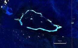 Satellite image | |
 | |
 Conflict Islands Location of the Conflict Islands | |
| Geography | |
|---|---|
| Location | Oceania |
| Coordinates | 10°46′48″S 151°47′32″E / 10.78000°S 151.79222°ECoordinates: 10°46′48″S 151°47′32″E / 10.78000°S 151.79222°E[1] |
| Archipelago | Louisiade Archipelago |
| Adjacent bodies of water | Solomon Sea |
| Total islands | 21 |
| Major islands | |
| Area | 4.55 km2 (1.76 sq mi) |
| Length | 21 km (13 mi) |
| Width | 10 km (6 mi) |
| Administration | |
| Province |
|
| District | Samarai-Murua District |
| LLG[2] | Bwanabwana Rural LLG |
| Island Group | Calvados Chain |
| Largest settlement | Irai (pop. 20) |
| Demographics | |
| Population | 30 (2014) |
| Pop. density | 6.6 /km2 (17.1 /sq mi) |
| Ethnic groups | Papauans, Austronesians, Melanesians. |
| Additional information | |
| Time zone | |
| ISO code | PG-MBA |
| Official website |
www |
The Conflict Group is an atoll in Papua New Guinea. The group was sighted in 1879 by HMS Cormorant, by moonlight; it was named in 1880 by Bower, captain of HMS Conflict.[3] Irai Island is the center of population of the group. The small Panasea Island has an eco resort with a small staff.
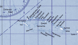
Islands in Conflict Group
The individual islands in a clockwise direction, starting in the west (Kisa and Itamarina in the lagoon):
Differing surface areas, and sometimes divergent names for individual islands can be found in Oceandots : Irai (97 ha), Panasesa (63.5 ha), Auriora (61 ha), Panarakum (38.8 ha), Panibari (24.7 ha ), Tubiniguam (17.8 ha), Moniara (13 ha), Ginouri (11 ha) and Tupit (10 ha). Thereafter, the total land area of the archipelago is 3.75 km² [4]
References
- ↑ Prostar Sailing Directions 2004 New Guinea Enroute, p. 168
- ↑ LLG map
- ↑ Arthur Wichman (Hrsg.): History of New-Guinea (bis 1828). Bd. 1, E. J. Brill, Leiden 1909, S. 271
- ↑ Oceandots.com: Conflict Islands
This article is issued from
Wikipedia.
The text is licensed under Creative Commons - Attribution - Sharealike.
Additional terms may apply for the media files.