Auriroa Island
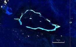 Satellite image | |
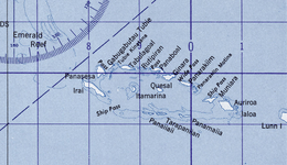 | |
 Auriroa Island Location of the Conflict Islands | |
| Geography | |
|---|---|
| Location | Oceania |
| Coordinates | 10°48′13″S 151°55′8″E / 10.80361°S 151.91889°ECoordinates: 10°48′13″S 151°55′8″E / 10.80361°S 151.91889°E[1] |
| Archipelago | Louisiade Archipelago |
| Adjacent bodies of water | Solomon Sea |
| Total islands | 1 |
| Major islands |
|
| Area | 0.76 km2 (0.29 sq mi) |
| Administration | |
| Province |
|
| District | Samarai-Murua District |
| LLG [2] | Bwanabwana Rural LLG |
| Island Group | Conflict Group |
| Demographics | |
| Population | 0 (2014) |
| Pop. density | 0 /km2 (0 /sq mi) |
| Ethnic groups | Papauans, Austronesians, Melanesians. |
| Additional information | |
| Time zone | |
| ISO code | PG-MBA |
| Official website |
www |
Auriroa Island is an island in Milne Bay Province of Papua New Guinea.[3]
It is in the Conflict Group archipelago, part of the Louisiade Archipelago in the Solomon Sea.
References
- ↑ Prostar Sailing Directions 2004 New Guinea Enroute, p. 168
- ↑ LLG map
- ↑ Auriroa Island: Papua New Guinea National Geospatial-Intelligence Agency, Bethesda, MD, USA
This article is issued from
Wikipedia.
The text is licensed under Creative Commons - Attribution - Sharealike.
Additional terms may apply for the media files.