Lunn Island
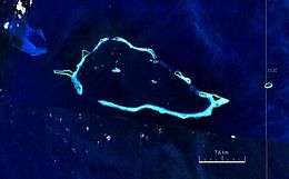 Satellite image | |
 | |
 Lunn Island | |
| Geography | |
|---|---|
| Location | Oceania |
| Coordinates | 10°47′13″S 152°0′8″E / 10.78694°S 152.00222°ECoordinates: 10°47′13″S 152°0′8″E / 10.78694°S 152.00222°E[1] |
| Archipelago | Louisiade Archipelago |
| Adjacent bodies of water | Solomon Sea |
| Total islands | 1 |
| Major islands |
|
| Area | 0.51 km2 (0.20 sq mi) |
| Length | 1.15 km (0.715 mi) |
| Width | 0.55 km (0.342 mi) |
| Administration | |
| Province |
|
| District | Samarai-Murua District |
| LLG [2] | Bwanabwana Rural LLG |
| Ward | Conflict Group |
| Demographics | |
| Population | 0 (2014) |
| Pop. density | 0 /km2 (0 /sq mi) |
| Ethnic groups | Papauans, Austronesians, Melanesians. |
| Additional information | |
| Time zone | |
| ISO code | PG-MBA |
| Official website |
www |
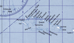
Lunn Island is a solitary island of Papua New Guinea in the Solomon Sea, belonging to the Louisiade Archipelago. It belongs to Milne Bay Province, to the ward of Conflict Group and is located between the Engineer Group, which is 8.3 kilometres (5.2 miles) to the west, and the Torlesse Islands, which are 18.3 kilometres (11.4 miles) to the east. The Deboyne Islands are another 22 kilometres (14 miles) eastward.
Lunn Island is uninhabited, densely wooded and has a land area of 51 hectares (130 acres). It is 1.14 kilometres (1,250 yards) long and up to 550 metres (600 yards) wide.
References
This article is issued from
Wikipedia.
The text is licensed under Creative Commons - Attribution - Sharealike.
Additional terms may apply for the media files.