Baluan Island
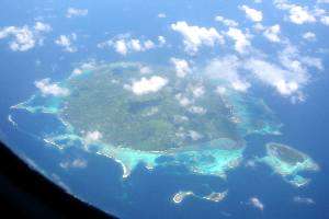 Balaun Island from the air | |
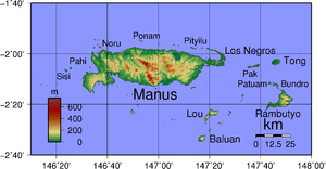 Map of the Admiralty Islands | |
| Geography | |
|---|---|
| Coordinates | 2°33′30″S 147°17′02″E / 2.558265°S 147.283895°ECoordinates: 2°33′30″S 147°17′02″E / 2.558265°S 147.283895°E |
| Administration | |
| Province | Manus Province |
Baluan Island is the southern most island of the Admiralty Islands group which make up the majority of Manus Province in Papua New Guinea. It belongs to the Pam Islands, an island sub group to the south of Lou Island. It is formed from an extinct volcano. The crater of the volcano can be seen from the top of the island.
The main foods on the island are fish and vegetables grown on the perfect growing volcanic soil.
The most famous Baluan person was Sir Paliau Moloat (1893-1991), who was elected as the First National Member of Assembly for Manus Province in 1964. He died in 1991 and is buried on Baluan.
This article is issued from
Wikipedia.
The text is licensed under Creative Commons - Attribution - Sharealike.
Additional terms may apply for the media files.