Hausvik
| Haus Hausvik | |
|---|---|
| Village | |
 Haus Location in Hordaland county  Haus Haus (Norway) | |
| Coordinates: 60°27′11″N 05°29′45″E / 60.45306°N 5.49583°ECoordinates: 60°27′11″N 05°29′45″E / 60.45306°N 5.49583°E | |
| Country | Norway |
| Region | Western Norway |
| County | Hordaland |
| District | Nordhordland |
| Municipality | Osterøy |
| Area[1] | |
| • Total | 0.38 km2 (0.15 sq mi) |
| Elevation[2] | 7 m (23 ft) |
| Population (2013)[1] | |
| • Total | 619 |
| • Density | 1,629/km2 (4,220/sq mi) |
| Time zone | UTC+01:00 (CET) |
| • Summer (DST) | UTC+02:00 (CEST) |
| Post Code | 5286 Haus |
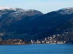
Haus or Hausvik is a village in Osterøy municipality in Hordaland county, Norway. The village is located on the southwestern coast of the island of Osterøy along the Sørfjorden. The village lies across the Sørfjorden from the villages of Ytre Arna and Garnes. The village of Valestrandfossen lies about 7 kilometres (4.3 mi) north along the fjord. The 0.38-square-kilometre (94-acre) village has a population (2013) of 619, giving the village a population density of 1,629 inhabitants per square kilometre (4,220/sq mi).[1]
The Osterøy Bridge is located about 4 kilometres (2.5 mi) south of Hausvik, connecting Osterøy island to the mainland of Bergen. Before the opening of the bridge in 1997, there was a regular ferry route from Hausvik to Garnes. The ferry route was discontinued after the bridge opened.[3]
Haus Church is located in the village, serving the southwestern part of Osterøy. The village of Haus was the administrative centre of the old municipality of Haus that existed from 1838 until 1964.[3]
References
- 1 2 3 Statistisk sentralbyrå (1 January 2013). "Urban settlements. Population and area, by municipality".
- ↑ "Haus, Osterøy" (in Norwegian). yr.no. Retrieved 2014-04-23.
- 1 2 Store norske leksikon. "Hausvik" (in Norwegian). Retrieved 2014-04-23.