Fitjar (village)
| Fitjar | |
|---|---|
| Village | |
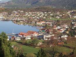 View of the village | |
 Fitjar Location in Hordaland county  Fitjar Fitjar (Norway) | |
| Coordinates: 59°55′04″N 05°19′00″E / 59.91778°N 5.31667°ECoordinates: 59°55′04″N 05°19′00″E / 59.91778°N 5.31667°E | |
| Country | Norway |
| Region | Western Norway |
| County | Hordaland |
| District | Sunnhordland |
| Municipality | Fitjar |
| Area[1] | |
| • Total | 1.33 km2 (0.51 sq mi) |
| Elevation[2] | 4 m (13 ft) |
| Population (2013)[1] | |
| • Total | 1,472 |
| • Density | 1,107/km2 (2,870/sq mi) |
| Time zone | UTC+01:00 (CET) |
| • Summer (DST) | UTC+02:00 (CEST) |
| Post Code | 5419 Fitjar |
![]()
Name
The village (and municipality) is named after the old Fitjar farm, since the first Fitjar Church was built there. The name is the plural form of fit which means "vigorous meadow". Before 1900, the name was spelled "Fitje".[4]
References
- 1 2 3 Statistisk sentralbyrå (1 January 2013). "Urban settlements. Population and area, by municipality".
- ↑ "Fitjar, Fitjar (Hordaland)" (in Norwegian). yr.no. Retrieved 2015-01-26.
- ↑ Store norske leksikon. "Fitjar – tettstaden" (in Norwegian). Retrieved 2015-01-26.
- ↑ Rygh, Oluf (1910). Norske gaardnavne: Søndre Bergenhus amt (in Norwegian) (11 ed.). Kristiania, Norge: W. C. Fabritius & sønners bogtrikkeri. p. 156.