Orontes River
| Orontes | |
| Greek: Ὀρόντης, Arabic: العاصي: ‘Āṣī, Turkish: Asi | |
| River | |
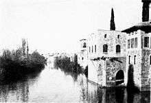
 Orontes River in Hama, Syria | |
| Countries | Lebanon, Syria, Turkey |
|---|---|
| Cities | Homs, Hama, Jisr al-Shughur, Antakya |
| Source | Labweh |
| - location | Beqaa Valley, Lebanon |
| - elevation | 910 m (2,986 ft) |
| - coordinates | 34°11′49″N 36°21′9″E / 34.19694°N 36.35250°E |
| Mouth | Samandağ |
| - location | Hatay Province, Turkey |
| - coordinates | 36°2′43″N 35°57′49″E / 36.04528°N 35.96361°ECoordinates: 36°2′43″N 35°57′49″E / 36.04528°N 35.96361°E |
| Length | 571 km (355 mi) |
| Basin | 24,660[1] km2 (9,521 sq mi) |
| Discharge | |
| - average | 11 m3/s (388 cu ft/s) |
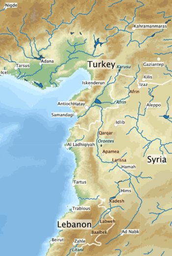
The Orontes (/əˈrɒntiːz/; Ancient Greek: Ὀρόντης) or Asi (Arabic: العاصي, ‘Āṣī; Turkish: Asi) is a northward-flowing river which begins in Lebanon and flows through Syria and Turkey before entering the Mediterranean Sea.[1]
In ancient times, it was the chief river of the Levant region and the site of several major battles. On it was the classical city of Antioch on the Orontes (Syrian Antioch) near modern day Antakya.
Name
In the 9th century BCE, the ancient Assyrians referred to the river as Arantu, and the nearby Egyptians called it Araunti.[2] The etymology of the name is unknown,[2] yet some sources indicate that it might be derived from "Arnt" which means "lioness" in Syriac languages;[note 1] others called it "Alimas", a "water goddess" in Aramaic.[3] However, Arantu gradually became "Orontes" in Greek.
In contrast, Macedonian settlers in Apamea named it the Axius, after a Macedonian river god. The modern name ‘Āṣī (or Asi) is derived from the ancient Axius. The word coincidentally means "rebel" in Arabic, which folk etymology ascribes to the fact that the river flows from the south to the north unlike the rest of the rivers in the region.[4][5]
The Greek geographer Strabo refers to the river in the Geographica (circa 20 CE). According to Strabo, the river was originally named Typhon, because it was said that Zeus had struck the dragon Typhon down from the sky with thunder, and the river had formed where Typhon's body had fallen.[6] He writes that the river was later renamed Orontes when a man named Orontes built a bridge on it.[6]
In the Greek epic poem Dionysiaca (circa 400 CE), the river is named after Orontes, an Indian military leader who killed himself and fell into the river after losing to Dionysus in single combat. [7]
Course
The Orontes rises in the springs near Labweh in Lebanon on the east side of the Beqaa Valley (in the Beqaa Governorate) between Mount Lebanon on the west and the Anti-Lebanon Mountains on the east, very near the source of the southward-flowing Litani, and runs north, falling 600 metres (2,000 ft) through a gorge to leave the valley.[1] The Ain ez Zarqa is one such major spring.[8] Other major springs are Al Ghab, Al Rouj, and Al-Azraq.[1]
Leaving this gorge, it expands into the Lake of Homs in Syria (an artificial lake created by a Roman-era dam, also known as Qattinah lake) and through the city of Homs (or Ḥimṣ). Below is the district of Hamah (Hamaih-Epiphaneia), and the ancient site of Larissa (Shaizar). This is where the river enters the Ghab plain.

Further downstream, on the eastern edge of the Ghab, is located the ancient city of Apamea.[1] To the west is the Coastal Mountain Range. This section ends at the rocky barrier of Jisr al-Hadid, where the river turns west into the plain of Antioch (Amik Valley) in Turkey.[1]
Two major tributaries are the southward flowing Afrin on the west and Karasu on the east join it through the former Lake of Antioch now via an artificial channel (Nahr al-Kowsit). Passing north of the modern Antakya (ancient Antioch) the Orontes dives southwest into a gorge (compared by the ancients to Tempe), and falls 50 metres (160 ft) in 16 kilometres (9.9 mi) to the sea just south of Samandağ (former Suedia, in antiquity Seleucia Pieria), after a total course of 450 kilometres (280 mi).[1]
| Name | Nearest City | Year | Height (m) | Capacity (million m3) | Note |
|---|---|---|---|---|---|
| Al-Rastan | Homs | 1960 | 67 | 228 | |
| Qattinah | Homs | 1976 | 7 | 200 | originally built 284 CE |
| Mouhardeh | Homs | 1960 | 41 | 67 | |
| Zeyzoun | Hamah | 1995 | 43 | 71 | failed 2002 |
| Kastoun | Hamah | 1992 | 20 | 27 |
History
The Orontes is not easily navigable and the valley derives its historical importance as a road for north/south traffic; from Antioch south to Homs and thence to Damascus via Al-Nabek (An-Nabk).[1] On the Orontes was fought the major Battle of Kadesh (circa 1274 BCE) between the Egyptian army of Ramesses II from the south and the Hittite army of Muwatalli II from the north. The river was also the site of the Battle of Qarqar fought in 853 BCE, when the army of Assyria, led by king Shalmaneser III, encountered an allied army of 12 kings led by Hadadezer of Damascus. In 637 CE the Battle of Iron bridge was fought between the forces of the Rashidun Caliphate and the Byzantine Empire near the Iron bridge on the river made by Romans.
The Orontes has long been a boundary marker. For the Egyptians it marked the northern extremity of Amurru, east of Phoenicia. For the Crusaders in the 12th century, the Orontes River became the permanent boundary between the Principality of Antioch and that of Aleppo.
Pliny the Elder mentioned a tributary of the Orontes as Marsyas river (named after Marsyas).[9] The same tributary was drawn by Richard Pococke to the east of the Orontes in the Al-Ghab plain near Apamea.[10] Other derivation of the river's name is Mimas, as known in Homs,[11] named after Deir Mimas in honor of Saint Mamas.[12]
The French writer Maurice Barrès (1862–1923) wrote about the river in his Un Jardin sur l'Oronte.[13]
See also
History and archaeology
- Battle of Kadesh
- Al-Mina - archaeological site at the mouth of the Orontes
- Tell Tayinat and Tell Atchana - archaeological sites near each other in Hatay.
- Qatna - ancient city near Homs.
- Kadesh (Syria) - ancient city, later known as Laodicea ad Libanum.
- Baalbek - a town and archaeological site just to the south of the source of the Orontes.
- Principality of Antioch - a crusader state (1098–1268) centered on the Orontes
- Seleucia ad Belum, Antigonia, Antioch - ancient cities on the Orontes founded during the Seleucid Empire
Dams and water management
Notes
References
- 1 2 3 4 5 6 7 8 9 "Asi-Orontes Basin". Food and Agriculture Organization of the United Names. 2016. Retrieved 18 March 2018.
- 1 2 Gaston Maspero. History of Egypt, Chaldæa, Syria, Babylonia and Assyria (Complete). p. 1348.
- ↑ Ballabio, R.; Comair, F.G.; Scalet, M.; Scoullos, M. (2015). Science diplomacy and transboundary water management: the Orontes River case. UNESCO Publishing. p. 89. ISBN 9789230000172.
- ↑ Fitchett, Joseph; Deford, McAdams (1973). "A River Called Rebel". Aramco World (May/June): 12–21. Retrieved 15 February 2015.
- ↑ Getzel M. Cohen. The Hellenistic Settlements in Syria, the Red Sea Basin, and North Africa. p. 100.
- 1 2 "LacusCurtius • Strabo's Geography — Book XVI Chapter 2". penelope.uchicago.edu. Retrieved 2017-02-03.
- ↑ Nonnos of Panopolis (20 July 2015). Delphi Complete Dionysiaca of Nonnus (Illustrated). Delphi Classics. pp. book 17.
- ↑ Scheffel, Richard L.; Wernet, Susan J., eds. (1980). Natural Wonders of the World. United States of America: Reader's Digest Association, Inc. p. 34. ISBN 0-89577-087-3.
- ↑ "Marsyas". Dictionary of Greek and Roman Geography.
- ↑ Richard Pococke (1743). A description of the East, and some other countries Vol. II. William Bowyer. p. 140.
- ↑ عمر فاروق الطباع (2016). ديوان البحتري 1/2 Diwan of Buhturi (in Arabic). Beirut: دار الارقم بن ابي الارقم. p. 169.
- ↑ مصطفى الصوفي (2017). طقوس احتفالات المواسم والأعياد الربيعية (in Arabic). ktab INC.
- ↑ Barrès, Maurice (1922). Un jardin sur l'Oronte. Paris.

External Sources
Pop-up map of the Orontes River available at: "Trace elements concentration in sediments of Orontes River using PIXE technique". Nuclear Instruments and Methods in Physics Research Section B: Beam Interactions with Materials and Atoms. 269: 1818–1821. doi:10.1016/j.nimb.2011.05.006.
Map of the Orontes River Basin: "Inventory of Shared Water Resources in Western Asia: Orontes Basin" (PDF). United Nations. 2012. Retrieved 21 March 2018.
| History |  | ||||||||
|---|---|---|---|---|---|---|---|---|---|
| Geography |
| ||||||||
| Politics |
| ||||||||
| Economy |
| ||||||||
| Society |
| ||||||||